National Register of Historic Places listings in Panola County, Mississippi
This is a list of the National Register of Historic Places listings in Panola County, Mississippi.
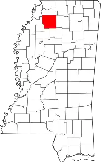
Location of Panola County in Mississippi
This is intended to be a complete list of the properties and districts on the National Register of Historic Places in Panola County, Mississippi, United States. Latitude and longitude coordinates are provided for many National Register properties and districts; these locations may be seen together in a map.[1]
There are 28 properties and districts listed on the National Register in the county.
- This National Park Service list is complete through NPS recent listings posted February 5, 2021.[2]
Current listings
| [3] | Name on the Register[4] | Image | Date listed[5] | Location | City or town | Description |
|---|---|---|---|---|---|---|
| 1 | Ballentine-Bryant House | 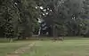 Ballentine-Bryant House |
April 9, 1984 (#84002287) |
506 Butler St. 34°25′45″N 89°54′38″W |
Sardis | |
| 2 | Ballentine-Seay House | April 9, 1984 (#84002289) |
Pocahontas St. 34°25′45″N 89°55′01″W |
Sardis | ||
| 3 | Batesville Historic District | November 12, 2003 (#03000686) |
Roughly along Panola Ave. and Boothe, Court, Church, Central, Kyle, Baker, and Lester Sts. 34°18′56″N 89°57′09″W |
Batesville | ||
| 4 | Batesville Mounds (22Pa500) | 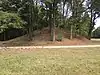 Batesville Mounds (22Pa500) |
December 14, 1988 (#88002702) |
Along Highway 35 North, west of Interstate 55 34°20′53″N 89°55′23″W |
Batesville | Formerly a restricted address, Batesville Mounds was opened as a public park in 2018[6] |
| 5 | Como Commercial Historic District | July 10, 2008 (#08000675) |
Roughly bounded by Elder Frank Ward St. on the west, N. Main St on the east, and Church Ave. on the north 34°30′39″N 89°56′33″W |
Como | ||
| 6 | Craig-Seay House | April 9, 1984 (#84002292) |
Craig St. 34°30′56″N 89°56′21″W |
Como | ||
| 7 | Crenshaw House | April 9, 1984 (#84002295) |
Mississippi Highway 310 34°30′10″N 90°11′36″W |
Crenshaw | ||
| 8 | Fredonia Church | March 30, 1978 (#78001626) |
6 miles (9.6 km) east of Como on Old Union Rd. 34°30′10″N 89°49′40″W |
Como | ||
| 9 | Fredrickson No. 2 (22-Pa-821) | July 28, 1988 (#88001139) |
Address Restricted |
Batesville | ||
| 10 | Hall-Henderson House | April 9, 1984 (#84002298) |
Sycamore St. 34°26′09″N 89°54′54″W |
Sardis | ||
| 11 | Hall-Roberson House | 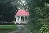 Hall-Roberson House |
April 9, 1984 (#84002300) |
510 S. Main St. 34°25′33″N 89°54′47″W |
Sardis | |
| 12 | Holly Grove Site | October 21, 1976 (#76001106) |
Address Restricted |
Sledge | ||
| 13 | Holy Innocents' Episcopal Church | November 5, 1987 (#87001936) |
Junction of Main and Craig St. 34°30′51″N 89°56′31″W |
Como | ||
| 14 | Hufft House | 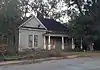 Hufft House |
April 9, 1984 (#84002302) |
117 Pocahontas St. 34°26′15″N 89°55′10″W |
Sardis | |
| 15 | Hunt Mound (22Pa980) | December 14, 1988 (#88002701) |
Address Restricted |
Pope | ||
| 16 | Johnson-Tate Cottage | April 9, 1984 (#84002305) |
Stonewall St. 34°26′20″N 89°54′55″W |
Sardis | ||
| 17 | John Curtis Kyle House | 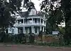 John Curtis Kyle House |
April 9, 1984 (#84002309) |
109 McLaurin St. 34°26′00″N 89°54′52″W |
Sardis | |
| 18 | Judge John William Kyle Law Office | July 24, 1980 (#80002299) |
147 S. Main St. 34°26′11″N 89°54′52″W |
Sardis | ||
| 19 | Lee House | 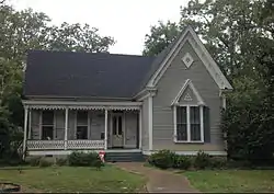 Lee House |
April 9, 1984 (#84002312) |
201 Booth St. 34°18′46″N 89°57′27″W |
Batesville | |
| 20 | Popular Price Store | April 9, 1984 (#84002316) |
Railroad St. 34°30′44″N 89°56′29″W |
Como | ||
| 21 | Short's Hill |  Short's Hill |
October 16, 1980 (#80002300) |
203 Childress St. 34°26′14″N 89°55′22″W |
Sardis | |
| 22 | Tait-Taylor House | April 9, 1984 (#84002319) |
Oak Ave. 34°30′35″N 89°56′20″W |
Como | ||
| 23 | Taylor-Falls House | 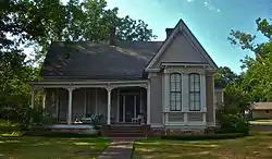 Taylor-Falls House |
April 9, 1984 (#84002321) |
Pointer Ave. 34°30′50″N 89°56′14″W |
Como | |
| 24 | Taylor-Mansker House | April 9, 1984 (#84002327) |
Railroad St. 34°30′54″N 89°56′22″W |
Como | ||
| 25 | Taylor-Wall-Yancy House | 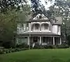 Taylor-Wall-Yancy House |
April 9, 1984 (#84002334) |
114 Sycamore St. 34°25′52″N 89°54′51″W |
Sardis | |
| 26 | Walton-Howry House | 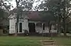 Walton-Howry House |
April 9, 1984 (#84002339) |
308 S. Main St. 34°25′56″N 89°54′57″W |
Sardis | |
| 27 | Wardlaw-Swango House | April 9, 1984 (#84002341) |
Railroad St. 34°30′49″N 89°56′26″W |
Como | ||
| 28 | The Well | December 17, 1982 (#82000579) |
East of Sardis on Sardis-Union Rd. 34°27′32″N 89°51′23″W |
Sardis | Coordinates in NRIS are off by approximately 0.6 miles (0.97 km) |
See also
| Wikimedia Commons has media related to National Register of Historic Places in Panola County, Mississippi. |
References
- The latitude and longitude information provided in this table was derived originally from the National Register Information System, which has been found to be fairly accurate for about 99% of listings. Some locations in this table may have been corrected to current GPS standards.
- "National Register of Historic Places: Weekly List Actions". National Park Service, United States Department of the Interior. Retrieved on February 5, 2021.
- Numbers represent an alphabetical ordering by significant words. Various colorings, defined here, differentiate National Historic Landmarks and historic districts from other NRHP buildings, structures, sites or objects.
- "National Register Information System". National Register of Historic Places. National Park Service. March 13, 2009.
- The eight-digit number below each date is the number assigned to each location in the National Register Information System database, which can be viewed by clicking the number.
- Paton, Alex (January 3, 2018). "Batesville opens Native American mound site". News Mississippi. Archived from the original on February 3, 2019. Retrieved February 3, 2019.
| Topics | |
|---|---|
| Lists by state |
|
| Lists by insular areas | |
| Lists by associated state | |
| Other areas | |
| Related | |
| |
Municipalities and communities of Panola County, Mississippi, United States | ||
|---|---|---|
| City | Map of Mississippi highlighting Panola County | |
| Towns | ||
| Village | ||
| Unincorporated communities | ||
| Ghost town | ||
| Footnotes | ‡This populated place also has portions in an adjacent county or counties | |
| ||
This article is issued from Wikipedia. The text is licensed under Creative Commons - Attribution - Sharealike. Additional terms may apply for the media files.