National Register of Historic Places listings in Pike County, Mississippi
This is a list of the National Register of Historic Places listings in Pike County, Mississippi.
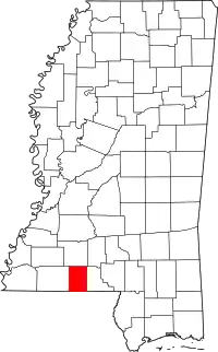
Location of Pike County in Mississippi
This is intended to be a complete list of the properties and districts on the National Register of Historic Places in Pike County, Mississippi, United States. Latitude and longitude coordinates are provided for many National Register properties and districts; these locations may be seen together in a map.[1]
There are 27 properties and districts listed on the National Register in the county. Another property was once listed but has been removed.
- This National Park Service list is complete through NPS recent listings posted January 29, 2021.[2]
Current listings
| [3] | Name on the Register[4] | Image | Date listed[5] | Location | City or town | Description |
|---|---|---|---|---|---|---|
| 1 | The Annex | October 11, 1984 (#84000036) |
225 Magnolia St. 31°08′41″N 90°27′31″W |
Magnolia | ||
| 2 | Bank of Summit | July 7, 1983 (#83000965) |
811 Robb St. 31°17′00″N 90°28′02″W |
Summit | ||
| 3 | Berryhill House | October 11, 1984 (#84000038) |
265 W. Railroad Ave. 31°08′44″N 90°27′28″W |
Magnolia | ||
| 4 | Brentwood | March 9, 1989 (#89000170) |
601 Delaware Ave. 31°14′42″N 90°26′51″W |
McComb | ||
| 5 | Buie Building | October 11, 1984 (#84000040) |
110 E. Railroad Ave. 31°08′37″N 90°27′27″W |
Magnolia | ||
| 6 | Carraway House | October 11, 1984 (#84000041) |
420 N. Clark St. 31°08′54″N 90°27′33″W |
Magnolia | ||
| 7 | George Chadwick House | 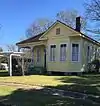 George Chadwick House |
October 11, 1984 (#84000043) |
560 N. Cherry St. 31°08′57″N 90°27′25″W |
Magnolia | |
| 8 | Depot | .jpg.webp) Depot |
October 11, 1984 (#84000045) |
101 E. Railroad Ave. 31°08′38″N 90°27′28″W |
Magnolia | |
| 9 | Phillip Henry Enochs House | March 20, 2002 (#02000208) |
1001 Dogwood Dr. 31°10′49″N 90°26′48″W |
Fernwood | ||
| 10 | Everette-Gottig-Bilbo House | October 11, 1984 (#84000046) |
109 E. Myrtle St. 31°08′49″N 90°27′35″W |
Magnolia | ||
| 11 | Holmes House | October 11, 1984 (#84000048) |
405 N. Cherry St. 31°08′52″N 90°27′30″W |
Magnolia | ||
| 12 | William Frederick Holmes House | 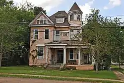 William Frederick Holmes House |
March 22, 2004 (#04000216) |
302 3rd St. 31°14′30″N 90°27′18″W |
McComb | |
| 13 | Kramertown-Railroad Historic District | March 13, 1980 (#80002301) |
S. Railroad Boulevard 31°14′29″N 90°26′59″W |
McComb | ||
| 14 | Lanier House | October 11, 1984 (#84000049) |
400 N. Clark St. 31°08′52″N 90°27′34″W |
Magnolia | ||
| 15 | Magnolia Manor | 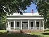 Magnolia Manor |
September 9, 1983 (#83000966) |
3rd and Amite Sts. 31°00′17″N 90°28′31″W |
Osyka | |
| 16 | McComb Downtown Historic District | April 14, 2004 (#04000279) |
Roughly bounded by Broadway, State, Front, and Canal Sts. 31°14′37″N 90°27′10″W |
McComb | ||
| 17 | Mullendore House | October 11, 1984 (#84000052) |
515 N. Cherry St. 31°08′56″N 90°27′28″W |
Magnolia | ||
| 18 | Myrtle Street Historic District | October 11, 1984 (#84000054) |
W. Myrtle St. between N. Clark and N. Prewitt Sts. 31°08′49″N 90°27′39″W |
Magnolia | ||
| 19 | Norwood-TWL Building | October 11, 1984 (#84000055) |
131 W. Railroad Ave. 31°08′38″N 90°27′31″W |
Magnolia | ||
| 20 | Simmons House | October 11, 1984 (#84000057) |
489 Prewitt St. 31°08′58″N 90°27′39″W |
Magnolia | ||
| 21 | Southtown Historic District | 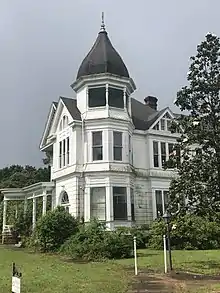 Southtown Historic District |
October 11, 1984 (#84000059) |
Roughly bounded by Minnehaha Creek, the Illinois Central railroad tracks, and Bay, Laurel, and Prewitt Sts. 31°08′32″N 90°27′41″W |
Magnolia | |
| 22 | Spinks Plantation | November 14, 2007 (#07001183) |
½ mile north of the junction of Muddy Springs and Irene Rds. 31°09′06″N 90°32′18″W |
Magnolia | ||
| 23 | States Area Neighborhood Historic District | September 10, 2014 (#14000571) |
Roughly bounded by Delaware, Louisiana, Pennsylvania & 5th Aves., 3rs & 21st Sts., Broadway, Hollywood Cemetery 31°14′38″N 90°27′34″W |
McComb | ||
| 24 | Stogner House | October 11, 1984 (#84000068) |
550 N. Cherry St. 31°08′56″N 90°27′26″W |
Magnolia | ||
| 25 | Tanglewood | August 23, 1991 (#91001102) |
County Road 468, 1 mile north of Mississippi Highway 48 31°08′02″N 90°22′44″W |
Magnolia | ||
| 26 | US Post Office-Magnolia | March 18, 1993 (#80004885) |
205 Magnolia St. 31°08′42″N 90°27′31″W |
Magnolia | ||
| 27 | White-Alford House |  White-Alford House |
April 21, 1983 (#83000967) |
845 White Boulevard 31°13′52″N 90°26′17″W |
McComb |
Former listing
| [3] | Name on the Register | Image | Date listed | Date removed | Location | City or town | Summary |
|---|---|---|---|---|---|---|---|
| 1 | Lieb-Rawls House | October 11, 1984 (#84000051) | August 7, 2002 | 303 Magnolia Street |
Magnolia |
See also
| Wikimedia Commons has media related to National Register of Historic Places in Pike County, Mississippi. |
References
- The latitude and longitude information provided in this table was derived originally from the National Register Information System, which has been found to be fairly accurate for about 99% of listings. Some locations in this table may have been corrected to current GPS standards.
- "National Register of Historic Places: Weekly List Actions". National Park Service, United States Department of the Interior. Retrieved on January 29, 2021.
- Numbers represent an alphabetical ordering by significant words. Various colorings, defined here, differentiate National Historic Landmarks and historic districts from other NRHP buildings, structures, sites or objects.
- "National Register Information System". National Register of Historic Places. National Park Service. March 13, 2009.
- The eight-digit number below each date is the number assigned to each location in the National Register Information System database, which can be viewed by clicking the number.
| Topics | |
|---|---|
| Lists by state |
|
| Lists by insular areas | |
| Lists by associated state | |
| Other areas | |
| Related | |
| |
Municipalities and communities of Pike County, Mississippi, United States | ||
|---|---|---|
| Cities | Map of Mississippi highlighting Pike County | |
| Towns | ||
| Unincorporated communities | ||
| ||
This article is issued from Wikipedia. The text is licensed under Creative Commons - Attribution - Sharealike. Additional terms may apply for the media files.