National Register of Historic Places listings in Tensas Parish, Louisiana
This is a list of the National Register of Historic Places listings in Tensas Parish, Louisiana.
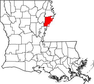
Location of Tensas Parish in Louisiana
This is intended to be a complete list of the properties on the National Register of Historic Places in Tensas Parish, Louisiana, United States. The locations of National Register properties for which the latitude and longitude coordinates are included below, may be seen in a map.[1]
There are 10 properties listed on the National Register in the parish. One property was once listed, but has since been removed.
- This National Park Service list is complete through NPS recent listings posted February 5, 2021.[2]
Current listings
| [3] | Name on the Register | Image | Date listed[4] | Location | City or town | Description |
|---|---|---|---|---|---|---|
| 1 | The Burn | August 11, 1982 (#82002798) |
North of Waterproof off Louisiana Highway 65 31°50′26″N 91°23′08″W |
Waterproof | ||
| 2 | Lakewood | March 24, 1983 (#83000547) |
North of St. Joseph on Louisiana Highway 606 31°57′57″N 91°12′30″W |
St. Joseph | ||
| 3 | Linwood Plantation Manager's House | 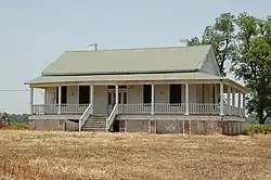 Linwood Plantation Manager's House |
September 23, 1994 (#94000705) |
Louisiana Highway 608 5 miles southeast of Newellton 32°01′42″N 91°10′36″W |
Newellton | |
| 4 | Moro Plantation House | October 5, 1982 (#82000468) |
West of Waterproof off Louisiana Highway 566 31°48′54″N 91°25′55″W |
Waterproof | ||
| 5 | Myrtle Grove Plantation | May 10, 1979 (#79001094) |
Louisiana Highway 568 31°48′47″N 91°22′07″W |
Waterproof | ||
| 6 | Routhwood Elementary School | October 6, 2015 (#15000698) |
217 Lombardo St. 32°04′19″N 91°14′21″W |
Newellton | ||
| 7 | St. Joseph Historic District |  St. Joseph Historic District |
December 10, 1980 (#80001763) |
Roughly bounded by Panola Ave. and Front, Hickory, 4th, and Pauline Sts. 31°54′58″N 91°14′10″W |
St. Joseph | |
| 8 | Tensas Parish Courthouse |  Tensas Parish Courthouse |
March 30, 1979 (#79001093) |
Courthouse Sq. 31°54′48″N 91°14′09″W |
St. Joseph | |
| 9 | Waterproof High School |  Waterproof High School |
April 1, 2002 (#02000296) |
Main St., between Church Ln. and Mississippi St. 31°49′N 91°23′W |
Waterproof | |
| 10 | Winter Quarters |  Winter Quarters |
November 21, 1978 (#78001437) |
6 miles (9.6 km) southeast of Newellton on Louisiana Highway 608 32°01′06″N 91°09′35″W |
Newellton |
Former listing
| [3] | Name on the Register | Image | Date listed | Date removed | Location | City or town | Summary |
|---|---|---|---|---|---|---|---|
| 1 | Bank of Newellton | June 2, 2000 (#00000613) | May 3, 2016 | 207 N. Main St. 32°04′38″N 91°14′08″W |
Newellton |
See also
| Wikimedia Commons has media related to National Register of Historic Places in Tensas Parish, Louisiana. |
References
- The latitude and longitude information provided in this table was derived originally from the National Register Information System, which has been found to be fairly accurate for about 99% of listings. Some locations in this table may have been corrected to current GPS standards.
- "National Register of Historic Places: Weekly List Actions". National Park Service, United States Department of the Interior. Retrieved on February 5, 2021.
- Numbers represent an alphabetical ordering by significant words. Various colorings, defined here, differentiate National Historic Landmarks and historic districts from other NRHP buildings, structures, sites or objects.
- The eight-digit number below each date is the number assigned to each location in the National Register Information System database, which can be viewed by clicking the number.
| Topics | |
|---|---|
| Lists by state |
|
| Lists by insular areas | |
| Lists by associated state | |
| Other areas | |
| Related | |
| |
Municipalities and communities of Tensas Parish, Louisiana, United States | ||
|---|---|---|
| Towns | | |
| Village | ||
| Unincorporated communities |
| |
| ||
This article is issued from Wikipedia. The text is licensed under Creative Commons - Attribution - Sharealike. Additional terms may apply for the media files.