National Register of Historic Places listings in Tuolumne County, California
This is a list of the National Register of Historic Places listings in Tuolumne County, California.
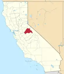
Location of Tuolumne County in California
This is intended to be a complete list of the properties and districts on the National Register of Historic Places in Tuolumne County, California, United States. Latitude and longitude coordinates are provided for many National Register properties and districts; these locations may be seen together in a Google map.[1]
There are 34 properties and districts listed on the National Register in the county, including 2 National Historic Landmarks.
- This National Park Service list is complete through NPS recent listings posted February 5, 2021.[2]
Current listings
| [3] | Name on the Register[4] | Image | Date listed[5] | Location | City or town | Description |
|---|---|---|---|---|---|---|
| 1 | Baker Highway Maintenance Station | September 2, 2004 (#04000928) |
33950 CA 108 38°19′48″N 119°45′22″W |
Strawberry | State highway maintenance housing and machinery complex, serving west of Sierra Nevada summit at Sonora Pass | |
| 2 | Cady House | Cady House |
February 25, 1982 (#82002281) |
72 N. Norlin St. 37°59′09″N 120°23′05″W |
Sonora | |
| 3 | Chinaman Mortar Site | June 20, 1975 (#75000492) |
Address Restricted |
Strawberry | ||
| 4 | City Hotel |  City Hotel |
June 30, 1983 (#83001248) |
145 S. Washington St. 37°59′01″N 120°22′51″W |
Sonora | |
| 5 | Columbia Historic District | 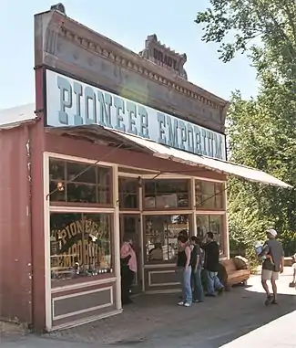 Columbia Historic District |
October 15, 1966 (#66000242) |
4 mi (6.4 km). northwest of Sonora on CA 49 38°02′09″N 120°24′04″W |
Sonora | |
| 6 | Cooper Cabin | January 9, 2009 (#08001314) |
Emigrant Wilderness, Stanislaus National Forest 38°14′03″N 119°49′44″W |
Strawberry | Historic cow camp cabin, from 1854 | |
| 7 | Emporium |  Emporium |
February 17, 1978 (#78000817) |
735 Main St. 37°57′10″N 120°25′22″W |
Jamestown | |
| 8 | Frog Creek Cabin | 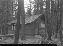 Frog Creek Cabin |
July 18, 2014 (#14000414) |
South shore of Lake Eleanor, along Frog Creek 37°58′59″N 119°50′37″W |
Yosemite | 1936-built cabin, used originally to support trout egg collection. |
| 9 | Gamble Building and Miner's Bean Kettle |  Gamble Building and Miner's Bean Kettle |
March 22, 1991 (#91000335) |
17544 CA 120 37°49′25″N 120°15′25″W |
Big Oak Flat | |
| 10 | Glen Aulin High Sierra Camp | 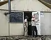 Glen Aulin High Sierra Camp |
July 18, 2014 (#14000415) |
At confluence of Tuolumne River and Alkali Creek 37°54′32″N 119°25′08″W |
Yosemite | |
| 11 | Great Sierra Mine Historic Site | 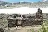 Great Sierra Mine Historic Site |
May 24, 1978 (#78000382) |
W of Lee Vining in Yosemite National Park 37°55′39″N 119°16′05″W |
Lee Vining | |
| 12 | Great Sierra Wagon Road | Great Sierra Wagon Road |
August 25, 1978 (#78000373) |
N of Yosemite Village 37°50′32″N 119°43′20″W |
Yosemite Valley | |
| 13 | Groveland Hotel |  Groveland Hotel |
May 6, 1994 (#94000428) |
18767 Main St. (CA 120) 37°50′22″N 120°13′42″W |
Groveland | |
| 14 | Hotel Charlotte |  Hotel Charlotte |
September 26, 1994 (#94001162) |
18736 Main St. (CA 120) 37°50′21″N 120°13′45″W |
Groveland | |
| 15 | Lake Vernon Snow Survey Shelter | July 18, 2014 (#14000416) |
Terminus of Lake Vernon Tr. 38°01′10″N 119°42′55″W |
Yosemite | ||
| 16 | Leighton Encampment | April 9, 2013 (#13000142) |
Roughly 12 mi. SW. of Pinecrest 38°07′33″N 119°46′47″W |
Pinecrest | Also known as Yellowhammer Camp | |
| 17 | May Lake High Sierra Camp | July 18, 2014 (#14000417) |
Eastern shore of May Lake 37°50′42″N 119°29′28″W |
Yosemite | ||
| 18 | McCauley Cabin | 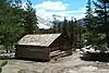 McCauley Cabin |
March 8, 1977 (#77000359) |
W of Lee Vining at Tuolumne Meadows 37°52′40″N 119°22′01″W |
Lee Vining | |
| 19 | Niagara Camp | June 6, 1975 (#75000494) |
NE of Tuolumne in Stanislaus National Forest 38°00′19″N 120°00′09″W |
Tuolumne | ||
| 20 | Parsons Memorial Lodge | 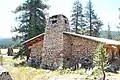 Parsons Memorial Lodge |
April 30, 1979 (#79000283) |
Tuolumne Meadows 37°52′42″N 119°22′00″W |
Yosemite National Park | |
| 21 | Quail Site | March 10, 1975 (#75000491) |
Address Restricted |
Long Barn | ||
| 22 | Sachse Spring Snow Survey Shelter | July 18, 2014 (#14000418) |
Off of Kibbie Ridge Tr. near Sachse Spring 38°04′51″N 119°50′34″W |
Yosemite | ||
| 23 | Soda Springs Cabin | 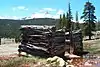 Soda Springs Cabin |
April 19, 1979 (#79000282) |
SW of Lee Vining 37°52′44″N 119°21′56″W |
Lee Vining | |
| 24 | Sonora Youth Center |  Sonora Youth Center |
October 8, 2009 (#09000807) |
732 S. Barretta St. 37°58′31″N 120°22′37″W |
Sonora | |
| 25 | Stanislaus Branch, California Forest and Range Experiment Station | January 15, 2009 (#08001315) |
Forest Rd. 4N13B 38°11′18″N 120°01′29″W |
Strawberry | ||
| 26 | Sugg House | 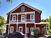 Sugg House |
September 13, 1984 (#84001210) |
37 Theall St. 37°59′02″N 120°22′49″W |
Sonora | |
| 27 | Tioga Pass Entrance Station | 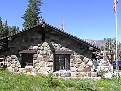 Tioga Pass Entrance Station |
December 14, 1978 (#78000372) |
SW of Lee Vining in Yosemite National Park 37°54′39″N 119°15′27″W |
Lee Vining | |
| 28 | Tuolumne County Courthouse | 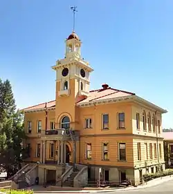 Tuolumne County Courthouse |
September 17, 1981 (#81000182) |
41 W. Yaney Ave. 37°59′08″N 120°22′59″W |
Sonora | |
| 29 | Tuolumne County Jail | 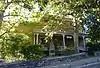 Tuolumne County Jail |
November 7, 1978 (#78000822) |
156 W. Bradford St. 37°59′02″N 120°23′04″W |
Sonora | |
| 30 | Tuolumne Meadows | November 30, 1978 (#78000371) |
SW of Lee Vining in Yosemite National Park 37°52′17″N 119°22′20″W |
Lee Vining | Listing is for CCC camp structures in the meadow area | |
| 31 | Tuolumne Meadows High Sierra Camp |  Tuolumne Meadows High Sierra Camp |
July 18, 2014 (#14000419) |
Along north banks of Dana Fork of Tuolumne River, east of Tuolumne Meadows 37°52′39″N 119°19′58″W |
Yosemite | |
| 32 | Tuolumne Meadows Ranger Stations and Comfort Stations | 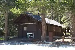 Tuolumne Meadows Ranger Stations and Comfort Stations |
December 18, 1978 (#78000370) |
SW of Lee Vining in Yosemite National Park 37°52′24″N 119°21′16″W |
Lee Vining | |
| 33 | Watts & Tannahill Company Store |  Watts & Tannahill Company Store |
March 31, 1995 (#95000265) |
18761 Main St. (CA 120) 37°50′21″N 120°13′43″W |
Groveland | |
| 34 | Yosemite Valley | 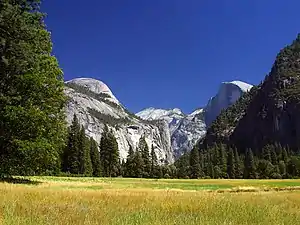 Yosemite Valley |
December 14, 2006 (#04001159) |
Yosemite National Park 37°43′43″N 119°36′07″W |
Yosemite |
See also
| Wikimedia Commons has media related to National Register of Historic Places in Tuolumne County, California. |
References
- The latitude and longitude information provided in this table was derived originally from the National Register Information System, which has been found to be fairly accurate for about 99% of listings. Some locations in this table may have been corrected to current GPS standards.
- "National Register of Historic Places: Weekly List Actions". National Park Service, United States Department of the Interior. Retrieved on February 5, 2021.
- Numbers represent an alphabetical ordering by significant words. Various colorings, defined here, differentiate National Historic Landmarks and historic districts from other NRHP buildings, structures, sites or objects.
- "National Register Information System". National Register of Historic Places. National Park Service. July 9, 2010.
- The eight-digit number below each date is the number assigned to each location in the National Register Information System database, which can be viewed by clicking the number.
| Topics | |
|---|---|
| Lists by state |
|
| Lists by insular areas | |
| Lists by associated state | |
| Other areas | |
| Related | |
| |
Municipalities and communities of Tuolumne County, California, United States | ||
|---|---|---|
| City | Tuolumne County map | |
| CDPs | ||
| Unincorporated communities | ||
| Ghost towns |
| |
| ||
This article is issued from Wikipedia. The text is licensed under Creative Commons - Attribution - Sharealike. Additional terms may apply for the media files.