National Register of Historic Places listings in Union Parish, Louisiana
This is a list of the National Register of Historic Places listings in Union Parish, Louisiana.
Location of Union Parish in Louisiana
This is intended to be a complete list of the properties on the National Register of Historic Places in Union Parish, Louisiana, United States. The locations of National Register properties for which the latitude and longitude coordinates are included below, may be seen in a map.[1]
There are 11 properties listed on the National Register in the parish.
- This National Park Service list is complete through NPS recent listings posted February 5, 2021.[2]
Current listings
| [3] | Name on the Register | Image | Date listed[4] | Location | City or town | Description |
|---|---|---|---|---|---|---|
| 1 | Alabama Methodist Church | March 30, 1995 (#95000298) |
Alternate Louisiana Highway 2 32°51′35″N 92°43′31″W |
Bernice | ||
| 2 | Bernice Civic Clubhouse | 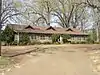 Bernice Civic Clubhouse |
April 21, 1994 (#94000374) |
Louisiana Highway 2 32°49′17″N 92°39′05″W |
Bernice | |
| 3 | Dual State Monument | 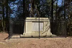 Dual State Monument |
September 11, 2000 (#99001354) |
Union County Road 86 33°00′39″N 92°22′05″W |
Marion | Extends into Union County, Arkansas |
| 4 | Edgewood | October 8, 1980 (#80001765) |
1 mile west of Farmerville on the Bernice Highway 32°47′12″N 92°25′30″W |
Farmerville | ||
| 5 | Garland House | January 7, 1994 (#93001495) |
701 Cherry St. 32°49′03″N 92°39′27″W |
Bernice | ||
| 6 | J.W. Heard House | January 7, 1994 (#93001494) |
605 Cherry St. 32°49′05″N 92°39′28″W |
Bernice | ||
| 7 | Hopkins House | March 14, 1983 (#83000549) |
Hopkins Lane 32°54′10″N 92°14′25″W |
Marion | ||
| 8 | Lindsey Bonded Warehouses | July 15, 1999 (#99000836) |
Holly and 2nd Sts. 32°49′28″N 92°39′18″W |
Bernice | ||
| 9 | R.T. Moore House | May 19, 1994 (#94000478) |
Northern side of Alternate Louisiana Highway 2, about 2 miles west of U.S. Route 167 32°50′40″N 92°40′52″W |
Bernice | ||
| 10 | Daniel Stein House | June 23, 1988 (#88000899) |
208 W. Bayou 32°46′31″N 92°24′29″W |
Farmerville | ||
| 11 | Dr. Terral Clinic | August 20, 1999 (#99001015) |
107 N. Washington St. 32°46′27″N 92°24′16″W |
Farmerville |
See also
| Wikimedia Commons has media related to National Register of Historic Places in Union Parish, Louisiana. |
References
- The latitude and longitude information provided in this table was derived originally from the National Register Information System, which has been found to be fairly accurate for about 99% of listings. Some locations in this table may have been corrected to current GPS standards.
- "National Register of Historic Places: Weekly List Actions". National Park Service, United States Department of the Interior. Retrieved on February 5, 2021.
- Numbers represent an alphabetical ordering by significant words. Various colorings, defined here, differentiate National Historic Landmarks and historic districts from other NRHP buildings, structures, sites or objects.
- The eight-digit number below each date is the number assigned to each location in the National Register Information System database, which can be viewed by clicking the number.
| Topics | |
|---|---|
| Lists by state |
|
| Lists by insular areas | |
| Lists by associated state | |
| Other areas | |
| Related | |
| |
Municipalities and communities of Union Parish, Louisiana, United States | ||
|---|---|---|
| Towns | | |
| Villages | ||
| Unincorporated communities | ||
| Footnotes | ‡This populated place also has portions in an adjacent parish or parishes | |
| ||
This article is issued from Wikipedia. The text is licensed under Creative Commons - Attribution - Sharealike. Additional terms may apply for the media files.