National Register of Historic Places listings in Valley County, Montana
This is a list of the National Register of Historic Places listings in Valley County, Montana. It is intended to be a complete list of the properties and districts on the National Register of Historic Places in Valley County, Montana, United States. The locations of National Register properties and districts for which the latitude and longitude coordinates are included below, may be seen in a map.[1]
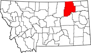
Location of Valley County in Montana
There are 13 properties and districts listed on the National Register in the county.
- This National Park Service list is complete through NPS recent listings posted January 29, 2021.[2]
Listings county-wide
| [3] | Name on the Register | Image | Date listed[4] | Location | City or town | Description |
|---|---|---|---|---|---|---|
| 1 | Administration Building | 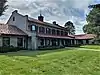 Administration Building |
August 13, 1986 (#86002058) |
E. Kansas Ave. 48°00′36″N 106°26′41″W |
Fort Peck | |
| 2 | Employee's Hotel and Garage | 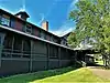 Employee's Hotel and Garage |
August 13, 1986 (#86002060) |
S. Missouri Ave. 48°00′32″N 106°26′47″W |
Fort Peck | |
| 3 | First National Bank of Glasgow | 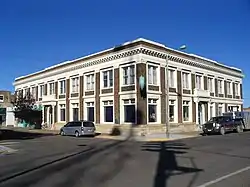 First National Bank of Glasgow |
June 27, 2002 (#02000698) |
110 5th St., S. 48°11′40″N 106°38′07″W |
Glasgow | |
| 4 | Fort Peck Dam | _1986_01.jpg.webp) Fort Peck Dam |
August 13, 1986 (#86002061) |
On the Missouri River 48°00′17″N 106°25′10″W |
Fort Peck | |
| 5 | Fort Peck Original Houses Historic District | 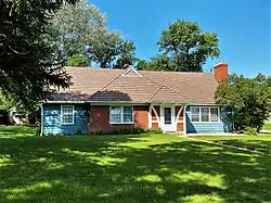 Fort Peck Original Houses Historic District |
August 13, 1986 (#86002067) |
1101-1112 E. Kansas Ave. 48°00′40″N 106°26′47″W |
Fort Peck | |
| 6 | Fort Peck Theatre | 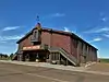 Fort Peck Theatre |
June 27, 1983 (#83001077) |
Missouri Ave. 48°00′27″N 106°27′00″W |
Fort Peck | |
| 7 | Garage and Fire Station | 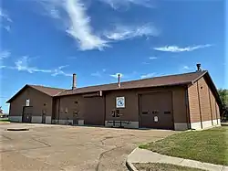 Garage and Fire Station |
August 13, 1986 (#86002063) |
Gasconade St. 48°00′29″N 106°26′51″W |
Fort Peck | |
| 8 | Glasgow Army Airfield Norden Bombsight Storage Vault | November 18, 2011 (#11000824) |
0.5 miles (0.80 km) north of Glasgow 48°13′13″N 106°36′33″W |
Glasgow vicinity | See also Second--Generation Norden Bombsight Vault, McCook, Nebraska | |
| 9 | Hospital | 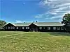 Hospital |
August 13, 1986 (#86002054) |
S. Platte St. 48°00′28″N 106°26′40″W |
Fort Peck | |
| 10 | Recreation Hall | 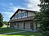 Recreation Hall |
August 13, 1986 (#86002066) |
Missouri Ave. 48°00′20″N 106°27′01″W |
Fort Peck | |
| 11 | Rundle Building | 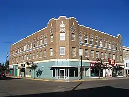 Rundle Building |
November 29, 2006 (#06001092) |
208 5th St., S. 48°11′38″N 106°38′13″W |
Glasgow | |
| 12 | Charles C. Sargent House | 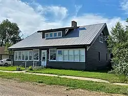 Charles C. Sargent House |
July 8, 1982 (#82003180) |
615 Front St. 48°07′56″N 106°21′17″W |
Nashua | |
| 13 | US Post Office and Courthouse-Glasgow Main | _-_Valley_County%252C_Montana.png.webp) US Post Office and Courthouse-Glasgow Main |
March 21, 1986 (#86000679) |
605 2nd Ave., S. 48°11′40″N 106°38′18″W |
Glasgow |
See also
| Wikimedia Commons has media related to National Register of Historic Places in Valley County, Montana. |
References
- The latitude and longitude information provided in this table was derived originally from the National Register Information System, which has been found to be fairly accurate for about 99% of listings. Some locations in this table may have been corrected to current GPS standards.
- "National Register of Historic Places: Weekly List Actions". National Park Service, United States Department of the Interior. Retrieved on January 29, 2021.
- Numbers represent an alphabetical ordering by significant words. Various colorings, defined here, differentiate National Historic Landmarks and historic districts from other NRHP buildings, structures, sites or objects.
- The eight-digit number below each date is the number assigned to each location in the National Register Information System database, which can be viewed by clicking the number.
| Topics | |
|---|---|
| Lists by state |
|
| Lists by insular areas | |
| Lists by associated state | |
| Other areas | |
| Related | |
| |
Municipalities and communities of Valley County, Montana, United States | ||
|---|---|---|
| City | Valley County map | |
| Towns | ||
| CDPs | ||
| Unincorporated communities | ||
| Indian reservations | ||
| Ghost towns | ||
| Footnotes | ‡This populated place also has portions in an adjacent county or counties | |
| ||
This article is issued from Wikipedia. The text is licensed under Creative Commons - Attribution - Sharealike. Additional terms may apply for the media files.