New Brunswick Route 11
Route 11 is a provincial highway in northeastern New Brunswick, Canada. The 429-kilometre (267 mi) road runs from Shediac to the Quebec border, near Campbellton, at the Interprovinciale Bridge, following the province's eastern and northern coastlines.
| ||||
|---|---|---|---|---|
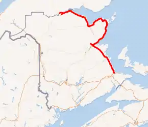
Route 11 highlighted in red | ||||
| Route information | ||||
| Maintained by New Brunswick Department of Transportation | ||||
| Length | 428.8 km[1] (266.4 mi) | |||
| Existed | 1920s–present | |||
| Major junctions | ||||
| South end | ||||
| North end | Interprovinciale Bridge (Quebec border) continues to | |||
| Location | ||||
| Major cities | Bouctouche, Richibucto, Miramichi, Tracadie–Sheila, Caraquet, Bathurst, Campbellton | |||
| Highway system | ||||
| Provincial highways in New Brunswick Former routes
| ||||


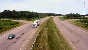
Between Shediac Bridge and Miramichi, and between Bathurst and Campbellton, it is a two-lane road with some sections designed as a Super two expressway. The highway is twinned for 7 kilometres in the Shediac region near the Route 15 interchange.
Route description
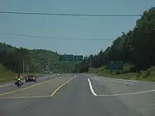
The highway's southern terminus is at an interchange with Route 15 in Shediac. It runs northward Parallel to Route 134 as a four-lane divided highway for 7 kilometres, then becomes a Super 2 controlled-access highway. The route passes through the communities of Shediac Cape, intersecting Route 134, then crossing the Shediac River, then entering Cocagne crossing the Cocagne River. Intersecting with Route 535, the route continues through Ward Corner passing McKees Mills and Saint-Francois-de-Kent at the intersection of Route 115. The Route Crosses the Little Bouctouche River then the Bouctouche River as it enters Bouctouche.
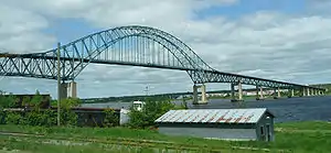
The Route then Continues to Richibucto as well as Kouchibouguac National Park. The highway reverts to a 2-lane uncontrolled access highway between the national park and the city of Miramichi to the northwest. The highway crosses the Miramichi River in the Miramichi borough of Chatham on the Centennial Bridge.
Immediately after crossing the Miramichi River, Route 11 interchanges with Route 8 (which turns north toward Bathurst on the direct route off the bridge). To follow Route 11, one must take the exit at the interchange and then continue on a 2-lane uncontrolled access highway northeast along the coast of Miramichi Bay and the Gulf of St. Lawrence as it runs around the perimeter of the Acadian Peninsula. Through this region, Route 11 typically forms the main street through most of the coastal towns and settlements such as Neguac, Caraquet, Bertrand, Grande-Anse, and Stonehaven. The only exception is a recently opened Super 2 controlled access bypass of the town of Tracadie-Sheila.
Route 11 interchanges again with Route 8 at Bathurst where Route 8 has its northern terminus. Route 11 becomes a Super 2 controlled access highway from Bathurst, running northwest several kilometres inland from the coast of Chaleur Bay to Glencoe, several kilometres west of the city of Campbellton. Near Glencoe, Route 11 interchanges in a T-intersection with Route 17 (Route 17 is a continuation of the direct Route 11 right-of-way).
To follow Route 11 further west to its northern terminus, one must turn at the intersection onto a 2-lane uncontrolled access local road which runs north to the Restigouche River taking the name Alford Drive, and then turn west and follow the river to the Interprovinciale Bridge which crosses the river at Matapedia, Quebec.
History
Since the late 1960s, Route 11 has received several upgrades and re-designations as it progresses toward eventually becoming an expressway.
The most significant upgrade to the entire highway route along the east coast of New Brunswick was the opening of the Centennial Bridge which replaced a ferry service and bypassed the town of Chatham in 1967.[2]
In 1973 a new 4-lane expressway opened between Moncton and Shediac, which was then referred to as the Shediac Four-Lane Highway or Shediac Expressway (it was subsequently numbered Route 15 and is known as the Veterans Memorial Highway).[3] Prior to this new expressway, Route 11 followed the Shediac Road from Shediac to Moncton, terminating at Route 2, the Trans-Canada Highway in Lakeville. Route 11's southern terminus was then changed to the current interchange at Route 15 in Shediac.
Controlled access Super 2 expressway sections on Route 11 were completed during the 1970s in Bathurst and the Campbellton-Dalhousie area, as well as between Shediac and Bouctouche.
During the 1980s and into the early 1990s, two long stretches of Super 2 expressway were completed on Route 11; one running from Bouctouche to Kouchibouguac National Park (bypassing Richibucto), and another running between Bathurst and Charlo, where the existing Super 2 section running east from Campbellton ended. The Super 2 section in Bathurst was also extended eastward past Salmon Beach at the city's east end.
A bypass of Tracadie-Sheila opened to traffic in 2003.[4] Also, an extension to that existing bypass was done in 2009, linking the northern end and Six-Roads, near Pokemouche.[5]

A bypass of Caraquet opened to traffic in 2016. Also going south from exiting Route 11 from Portage Road to Bertrand. The 13 km construction started in 2013, then finished in 2016.[6]
In 2017, work was completed on a new interchange between Route 11 and 15 in Shediac, and 7 kilometres of twinned highway.[7]
Currently, two other sections of highway are being twinned. The first is from the south side of the Shediac River to the Cocagne River, and the second from the north side of the Cocagne River to the Little Bouctouche River, meaning the highway will revert to two lanes across the Cocagne River on the current bridge.[8][9]
Major intersections
| County | Location | km[1] | mi | Exit | Destinations | Notes |
|---|---|---|---|---|---|---|
| Westmorland | Shediac | 0.0 | 0.0 | (0) | Eastbound exit, westbound entrance | |
| 0.9 | 0.56 | 1 | Westbound Route 15 access (via exit 31) to Route 11 | |||
| | 2.4 | 1.5 | 2 | |||
| Shediac Bridge | 6.8 | 4.2 | Crosses the Shediac River | |||
| 7.8 | 4.8 | 7 | ||||
| Kent | Cocagne | 14.1 | 8.8 | 13 | Southbound exit and entrance, full interchange proposed[10] | |
| 14.4– 14.9 | 8.9– 9.3 | Crosses the Cocagne River | ||||
| 15.6 | 9.7 | 15 | ||||
| | 27.2 | 16.9 | 27 | |||
| | 27.9 | 17.3 | Crosses the Little Bouctouche River | |||
| Bouctouche | 28.6 | 17.8 | 29 | Sheridan Road | ||
| 32.0 | 19.9 | Crosses the Bouctouche River | ||||
| 10.1 | 6.3 | 32 | Signed as exits 32A (east) and 32B (west) | |||
| | 35.6 | 22.1 | ||||
| Sainte-Anne-de-Kent | 41.5 | 25.8 | 42 | |||
| Rexton | 52.5 | 32.6 | 53 | |||
| 55.0– 55.6 | 34.2– 34.5 | Crosses the Richibucto River | ||||
| Richibucto | 56.3 | 35.0 | 57 | |||
| Saint-Charles | 63.1 | 39.2 | 64 | Saint-Charles, Aidouane | ||
| Saint-Louis-de-Kent | 68.4 | 42.5 | 69 | Saint-Louis, Saint-Ignace | ||
| 69.1 | 42.9 | Crosses the Kouchibouguacis River | ||||
| | 74.1 | 46.0 | 75 | |||
| | North end of freeway | |||||
| Kouchibouguac | 76.8 | 47.7 | ||||
| Northumberland | St. Margarets | 95.3 | 59.2 | |||
| Black River | 107.2 | 66.6 | ||||
| Miramichi | 118.5 | 73.6 | King Street | |||
| South end of freeway | ||||||
| 119.5 | 74.3 | 119 | South end of Route 8 concurrency | |||
| 120.7 | 75.0 | 120 | Church Street | |||
| 120.8– 121.9 | 75.1– 75.7 | Centennial Bridge crosses the Miramichi River | ||||
| 122.0 | 75.8 | 179 | King George Highway | North end of Route 8 concurrency | ||
| North end of freeway | ||||||
| Bartibog Bridge | 138.4 | 86.0 | Crosses the Bartibog River | |||
| Village-Saint-Laurent | 155.1 | 96.4 | ||||
| Neguac | 163.1 | 101.3 | ||||
| 165.3 | 102.7 | |||||
| Tabusintac | 171.9 | 106.8 | ||||
| 173.9 | 108.1 | Crosses the Tabusintac River | ||||
| | 175.2 | 108.9 | ||||
| Rivière-du-Portage | 185.5 | 115.3 | ||||
| Gloucester | Tracadie-Sheila | 191.5– 191.9 | 119.0– 119.2 | Crosses the Big Tracadie River | ||
| South end of freeway | ||||||
| 192.7 | 119.7 | 192 | ||||
| 194.1 | 120.6 | 194 | Principale Street | |||
| 196.9 | 122.3 | 198 | Riviere-a-la-Truite Street | |||
| 198.8– 199.2 | 123.5– 123.8 | Crosses the Little Tracadie River | ||||
| 201.8 | 125.4 | 203 | ||||
| North end of freeway | ||||||
| Six Roads | 209.2 | 130.0 | ||||
| 210.5 | 130.8 | |||||
| Pokemouche | 216.0 | 134.2 | Crosses the Pokemouche River | |||
| 216.7 | 134.7 | 217 | At-grade | |||
| | 220.1 | 136.8 | ||||
| Caraquet | 227.4 | 141.3 | South end of Caraquet Bypass | |||
| 232.6 | 144.5 | 234 | Interchange | |||
| Bertrand | 240.3 | 149.3 | Roundabout; north end of Caraquet Bypass | |||
| | 246.0 | 152.9 | ||||
| | 249.5 | 155.0 | ||||
| Grande-Anse | 253.6 | 157.6 | ||||
| Pokeshaw | 260.5 | 161.9 | ||||
| Janeville | 278.7 | 173.2 | ||||
| | South end of freeway | |||||
| Bathurst | 298.5 | 185.5 | 300 | Signed as exits 300A (north) and 300B (south) | ||
| 298.9– 299.8 | 185.7– 186.3 | 301 | Route 8 northern terminus | |||
| 301.3 | 187.2 | Crosses the Nepisiguit River | ||||
| 301.7 | 187.5 | 304 | ||||
| 306.9 | 190.7 | 308 | St-Anne Street | |||
| 308.4 | 191.6 | 310 | ||||
| 309.3 | 192.2 | 311 | ||||
| Beresford | 316.4 | 196.6 | 318 | |||
| Nigadoo | 319.6 | 198.6 | 321 | |||
| LaPlante | 324.4 | 201.6 | 326 | |||
| | 330.9 | 205.6 | 333 | |||
| Belledune | 337.8 | 209.9 | 344 | |||
| Restigouche | 348.8 | 216.7 | 351 | |||
| Nash Creek | 355.3 | 220.8 | 357 | |||
| Charlo | 373.7 | 232.2 | 375 | |||
| 378.0 | 234.9 | 385 | ||||
| | 380.6 | 236.5 | 388 | |||
| Dalhousie | 384.3 | 238.8 | 391 | |||
| Dalhousie Junction | 389.9 | 242.3 | 397 | |||
| | 395.8 | 245.9 | 403 | |||
| Campbellton | 404.8 | 251.5 | 412 | |||
| Atholville | 407.8 | 253.4 | 415 | Former Route 270 | ||
| Glencoe | North end of freeway | |||||
| 415.3 | 258.1 | Route 17 northern terminus | ||||
| Tide Head | 418.5 | 260.0 | Route 134 northern terminus | |||
| New Brunswick–Quebec border | 428.8– 429.8 | 266.4– 267.1 | Matapédia Bridge (Interprovinciale Bridge) crosses the Restigouche River | |||
| Gaspésie–Îles-de-la-Madeleine (Quebec) | Matapédia | 429.9 | 267.1 | T-intersection | ||
1.000 mi = 1.609 km; 1.000 km = 0.621 mi
| ||||||
References
- Google (January 16, 2020). "New Brunswick Route 11" (Map). Google Maps. Google. Retrieved January 16, 2020.
- Fowler, Shane (September 30, 2017). "Miramichi's Centennial Bridge marks 50 years as 'lifeline'". CBC. Retrieved December 4, 2019.
- "Extensive Improvements Planned for Highways". Telegraph Journal. February 28, 1974. Retrieved December 4, 2019.
- "Tracadie-Sheila bypass opens (03/10/30)". Communications New Brunswick. October 30, 2003. Retrieved December 4, 2019.
- "Tracadie-Sheila to Six Roads bypass completed (09/10/19)". Communications New Brunswick. October 19, 2009. Retrieved December 4, 2019.
- "La voie de contournement de Caraquet ouverte à la circulation". Acadie Nouvelle. October 10, 2016. Retrieved December 4, 2019.
- "Newly twinned section of Route 11 now open". New Brunswick Department of Transportation and Infrastructure. Retrieved November 30, 2019.
- Poitras, Jacques (March 21, 2019). "Ministers pile on confusion over Route 11 twinning pledge". CBC. Retrieved November 30, 2019.
- Poitras, Jacques (December 11, 2019). "2 stalled hospital units back on list of provincial capital projects". CBC. Retrieved December 13, 2019.
- "Route 11: Shediac to Little Bouctouche River" (PDF) (Map). Province of New Brunswick. January 2, 2011. Retrieved January 14, 2020.