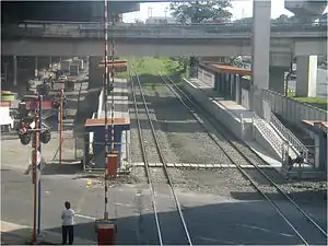
Nichols station
Nichols station (formerly Bonifacio-Villamor) is a station of the South Main Line ("Southrail") of the Philippine National Railways. Like all PNR stations, this station is At grade. It is located on the East Service Road of the South Luzon Expressway in Taguig, on the foot of the Sales Interchange, and takes its name from one of the area's popular nicknames, Nichols, which is also the former name of Villamor Airbase. It was opened for revenue service on March 25, 2010.
 Platform area of Nichols station. | |||||||||||
| Location | East Service Road, Western Bicutan Taguig, Metro Manila Philippines | ||||||||||
| Coordinates | 14°31′26.04″N 121°1′34.10″E | ||||||||||
| Owned by | Philippine National Railways | ||||||||||
| Line(s) | █ PNR Southrail | ||||||||||
| Platforms | Side platforms | ||||||||||
| Tracks | 2 | ||||||||||
| Construction | |||||||||||
| Structure type | At grade Underground (NSCR station)[1] | ||||||||||
| Disabled access | Yes | ||||||||||
| Other information | |||||||||||
| Station code | NIC | ||||||||||
| History | |||||||||||
| Opened | 1946 (flagstop) March 25, 2010 | ||||||||||
| Services | |||||||||||
| |||||||||||
| Location | |||||||||||
 Nichols Location within Metro Manila | |||||||||||
PNR Metro Commuter | ||||||||||||||||||||||||||||||||||||||||||||||||||||||||||||||||||||||||||||||||||||||||||||||||||||||||||||||||||||||||||||||||||||||||||||||||||||||||||||||||||||||||||||||||||||||||||||||||||||||||||||||||||||||||||||||||||||||||||||||||||||||||||||||||||||||||||||||||||||||||||||||||||||||||||||||||||||||||||||||||||||||||||||||||||||||||||||||||||||||||||||||||||||||||||||||||||||||||||||||||||||||||||||||||||||||||||||||||||||||||||||||||||||||||||||||||||||||||||||||||||||||||||||||||||||||||||||||||||||||||||||||||||||||||||||||||||||||||||||||||||||||||||||||||||||||||||||||||||||||||||||
|---|---|---|---|---|---|---|---|---|---|---|---|---|---|---|---|---|---|---|---|---|---|---|---|---|---|---|---|---|---|---|---|---|---|---|---|---|---|---|---|---|---|---|---|---|---|---|---|---|---|---|---|---|---|---|---|---|---|---|---|---|---|---|---|---|---|---|---|---|---|---|---|---|---|---|---|---|---|---|---|---|---|---|---|---|---|---|---|---|---|---|---|---|---|---|---|---|---|---|---|---|---|---|---|---|---|---|---|---|---|---|---|---|---|---|---|---|---|---|---|---|---|---|---|---|---|---|---|---|---|---|---|---|---|---|---|---|---|---|---|---|---|---|---|---|---|---|---|---|---|---|---|---|---|---|---|---|---|---|---|---|---|---|---|---|---|---|---|---|---|---|---|---|---|---|---|---|---|---|---|---|---|---|---|---|---|---|---|---|---|---|---|---|---|---|---|---|---|---|---|---|---|---|---|---|---|---|---|---|---|---|---|---|---|---|---|---|---|---|---|---|---|---|---|---|---|---|---|---|---|---|---|---|---|---|---|---|---|---|---|---|---|---|---|---|---|---|---|---|---|---|---|---|---|---|---|---|---|---|---|---|---|---|---|---|---|---|---|---|---|---|---|---|---|---|---|---|---|---|---|---|---|---|---|---|---|---|---|---|---|---|---|---|---|---|---|---|---|---|---|---|---|---|---|---|---|---|---|---|---|---|---|---|---|---|---|---|---|---|---|---|---|---|---|---|---|---|---|---|---|---|---|---|---|---|---|---|---|---|---|---|---|---|---|---|---|---|---|---|---|---|---|---|---|---|---|---|---|---|---|---|---|---|---|---|---|---|---|---|---|---|---|---|---|---|---|---|---|---|---|---|---|---|---|---|---|---|---|---|---|---|---|---|---|---|---|---|---|---|---|---|---|---|---|---|---|---|---|---|---|---|---|---|---|---|---|---|---|---|---|---|---|---|---|---|---|---|---|---|---|---|---|---|---|---|---|---|---|---|---|---|---|---|---|---|---|---|---|---|---|---|---|---|---|---|---|---|---|---|---|---|---|---|---|---|---|---|---|---|---|---|---|---|---|---|---|---|---|---|---|---|---|---|---|---|---|---|---|---|---|---|---|---|---|---|---|---|---|---|---|---|---|---|---|---|---|---|---|---|---|---|---|---|---|---|---|---|---|---|---|---|---|---|---|---|---|---|---|---|---|---|---|---|---|---|---|---|---|---|---|---|---|---|---|---|---|---|---|---|---|---|---|---|---|---|---|---|---|---|---|---|---|---|---|---|---|---|---|---|---|---|---|---|---|---|---|---|---|---|---|---|---|---|---|---|---|---|---|---|---|---|---|---|---|---|---|---|---|---|---|---|---|---|---|---|
| ||||||||||||||||||||||||||||||||||||||||||||||||||||||||||||||||||||||||||||||||||||||||||||||||||||||||||||||||||||||||||||||||||||||||||||||||||||||||||||||||||||||||||||||||||||||||||||||||||||||||||||||||||||||||||||||||||||||||||||||||||||||||||||||||||||||||||||||||||||||||||||||||||||||||||||||||||||||||||||||||||||||||||||||||||||||||||||||||||||||||||||||||||||||||||||||||||||||||||||||||||||||||||||||||||||||||||||||||||||||||||||||||||||||||||||||||||||||||||||||||||||||||||||||||||||||||||||||||||||||||||||||||||||||||||||||||||||||||||||||||||||||||||||||||||||||||||||||||||||||||||||
The station is the twelfth station from Tutuban and is one of two stations serving Taguig, the other station being FTI.
Nearby landmarks
Aside being near both Villamor Airbase and Fort Bonifacio, it is also near Terminal 3 of the Ninoy Aquino International Airport, Newport City, the headquarters of the Technical Education and Skills Development Authority (TESDA) and the Libingan ng mga Bayani. Further away from the station are the Philippine State College of Aeronautics, the Pasay City South High School, Magallanes Village in Makati, the Manila American Cemetery and Memorial, The Heritage Memorial Park, the Bonifacio Global City, McKinley Hill, and McKinley West.
Transportation links
Nichols station is accessible by jeepneys plying routes on the East Service Road, Lawton Avenue (the road which leads to Fort Bonifacio) and Sales Road (the road which leads to Villamor Airbase), as well as buses plying these routes.
Future
Nichols station will be rebuilt as an underground station for the North–South Commuter Railway. The new station is targeted for completion by 2025.[1]
Station Layout
| L1 Platforms |
Side platform, doors will open on the right | |
| Platform A | PNR Metro Commuter towards Tutuban (←) | |
| Platform B | PNR Metro Commuter towards Alabang (→) | |
| Side platform, doors will open on the right | ||
| L1 | Concourse/ Street Level |
Ticket Booths, Station Control, Shops, Sales Interchange |
References
- "Roadmap for Transport Infrastructure Development for Metro Manila and its Surrounding Areas (Region III and Region IV-A)" (PDF). Japan International Cooperation Agency. March 30, 2014. Retrieved May 7, 2020.