North Attleborough, Massachusetts
North Attleborough, alternatively spelled North Attleboro,[2] is a town in Bristol County, Massachusetts, United States. The population was 28,712 at the 2010 United States Census.
North Attleborough, Massachusetts | |
|---|---|
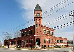
 North Attleborough Town Hall | |
 Seal | |
 Location in Bristol County in Massachusetts | |
| Coordinates: 41°59′00″N 71°20′00″W | |
| Country | United States |
| State | Massachusetts |
| County | Bristol |
| Settled | 1669 |
| Incorporated | 1887 |
| Government | |
| • Type | Town Manager & Town Council |
| • Town Manager | Michael Borg[1] |
| Area | |
| • Total | 19.1 sq mi (49.3 km2) |
| • Land | 18.6 sq mi (48.3 km2) |
| • Water | 0.4 sq mi (1.1 km2) |
| Elevation | 200 ft (61 m) |
| Population (2000) | |
| • Total | 28,712 |
| • Density | 1,456.0/sq mi (562.2/km2) |
| Time zone | UTC−5 (Eastern) |
| • Summer (DST) | UTC−4 (Eastern) |
| ZIP Code | 02760 |
| Area code(s) | 508/774 (508 Exchanges: 643,695,699) |
| FIPS code | 25-46575 |
| GNIS feature ID | 0618284 |
| Website | www |
The villages of Attleboro Falls and North Attleborough Center are located in the town.
History
In pre-Colonial times, the land was the site of the Bay Path, a major Native American trail to Narragansett Bay, the Seekonk River, and Boston. English settlers arrived in the area in 1634[3] and established the settlement of Rehoboth—which included the modern day towns of North Attleborough, Attleboro, Massachusetts, Somerset, Seekonk, as well as parts of Rhode Island—from land sold to them by the Pokanoket Wamsutta.[4] John Woodcock established a settlement in the territory in 1669 which subsisted on agriculture, fishing and hunting. By 1670, Woodcock had received a license to open a tavern. The settlement was attacked during King Philip's War, with two killed and one home burned, but the Garrison house which Woodcock had built survived the attack. The Woodcock-Garrison house was used as sleeping quarters for George Washington on his army's march to Boston to rid the city of General Thomas Gage's troops. The Town of Attleborough was incorporated from this territory in 1694.
In about 1780, a French settler set up a forge for working brass, beginning the industrial era.[5] Englishmen brought with them British machinery from Birmingham in 1794 and designed American improvements in button making, which they patented. During the 18th and early 19th centuries, small grist and sawmills were built along the Ten Mile River, and subsequently-established nail factories were eventually eclipsed by cotton spinning mills. The development of cotton spinning was spurred by the embargo on imports resulting from the War of 1812. Textiles and jewelry manufacturing were the staple industries of the town by 1832, but buttons became king, spurred by the American Civil War and U.S. Army orders for badges and medals. By 1834, Attleborough produced more buttons than anywhere else in the United States; by 1855, there were 24 shops making almost $1 million in jewelry in Attleborough.
In 1887, the residents of the village of East Attleborough voted to secede, and they had higher population and votes to take with them the name of Attleborough and the town's original founding date of 1694; they incorporated as the new City of Attleborough, and the remainder of the original town adopted the name North Attleborough.
In the twentieth century, North Attleborough was home at various times to the jewelry firms Jostens, the world's largest class ring manufacturer and the Balfour Company, prominent maker of championship rings including for the National Football League's Super Bowl champions and Major League Baseball's World Series' winners. In 2006, North Attleborough was rated in the top ten for professional sports communities in the entire country and was also listed as one of the most affordable and safest places to raise a family. Today, North Attleborough is still home to many professional athletes due to its proximity to Gillette Stadium just 5 miles away.
Geography
According to the United States Census Bureau, the town has a total area of 19.0 square miles (49 km2), of which 18.6 square miles (48 km2) is land and 0.4 square miles (1.0 km2) (2.15%) is water. The town is roughly quadrilateral-shaped, and makes the northwest corner of Bristol County. It is bordered by Plainville to the north, Mansfield to the east, Attleborough to the south, and Cumberland, Rhode Island to the west. Localities include Adamsdale, Attleborough Falls and Sheldonville Farms. The town is located 16 miles (26 km) north of Providence, Rhode Island, 38 miles (61 km) southwest of Boston and 42 miles (68 km) southeast of Worcester, Massachusetts.
The town has several rivers, streams and brooks running through it, including the Ten Mile River and the Seven Mile River. There are several ponds and lakes, including Greenwood Lake (site of a fish hatchery) and Falls Pond, among others. The town's largest park, World War I Memorial Park, is located in the northern part of town and contains the highest point in Bristol County - Sunrise Hill (Watery Hill) at 390 feet (120 m) above sea level. World War I Memorial Park features a petting zoo, Petti Field for soccer and lacrosse and a ski/sledding hill with J-bar ski lift which is currently inoperable. There is also the North Attleborough Arboretum adjacent to the park.
On High Street, one block from Route 1A is an ice-skating pond called Titus Pond which is maintained by the North Attleborough Rotary Club and filled each winter by the Fire Department.
There are five cemeteries in North Attleborough: the diminutive and inactive Woodcock Cemetery across from the Woodcock-Garrison house just north of downtown; Paine Road Cemetery near the Cumberland, Rhode Island, border; Mt. Hope Cemetery & Arboretum; the old St. Mary's Cemetery and the new St. Mary's Cemetery. The latter three are located in the village of Attleborough Falls.
Demographics
| Year | Pop. | ±% |
|---|---|---|
| 1890 | 6,727 | — |
| 1900 | 7,253 | +7.8% |
| 1910 | 9,562 | +31.8% |
| 1920 | 9,238 | −3.4% |
| 1930 | 10,197 | +10.4% |
| 1940 | 10,359 | +1.6% |
| 1950 | 12,146 | +17.3% |
| 1960 | 14,777 | +21.7% |
| 1970 | 18,665 | +26.3% |
| 1980 | 21,095 | +13.0% |
| 1990 | 25,038 | +18.7% |
| 2000 | 28,978 | +15.7% |
| 2010 | 28,712 | −0.9% |
| Source: United States Census records and Population Estimates Program data.[6][7][8][9][10][11][12] | ||
At the 2000 census,[13] there were 27,143 people, 10,391 households and 7,232 families residing in the town. The population density was 1,456.0 inhabitants per square mile (562.2/km2). There were 10,635 housing units at an average density of 570.5 per square mile (220.3/km2). The racial makeup of the town was 95.97% White, 0.92% African American, 0.12% Native American, 1.71% Asian, 0.02% Pacific Islander, 0.45% from other races, and 0.81% from two or more races. Hispanic or Latino of any race were 1.32% of the population.
There were 10,391 households, of which 36.0% had children under the age of 18 living with them, 57.0% were married couples living together, 9.4% had a female householder with no husband present, and 30.4% were non-families. 24.7% of all households were made up of individuals, and 7.3% had someone living alone who was 65 years of age or older. The average household size was 2.60 and the average family size was 3.15.
Age distribution was 26.9% under the age of 18, 6.6% from 18 to 24, 34.4% from 25 to 44, 22.5% from 45 to 64, and 9.7% who were 65 years of age or older. The median age was 36 years. For every 100 females, there were 94.6 males. For every 100 females age 18 and over, there were 91.3 males.
The median household income in 2016 was $90,125 compared to $59,371 in 2000. About 2.7% of families and 3.8% of the population were below the poverty line, including 5.0% of those under age 18 and 3.9% of those age 65 or over.
Arts and culture

Library
"The North Attleborough Public Library was established in 1889, by the North Attleborough Union Improvement District, which turned its library over to the town."[14] Today the Richards Memorial Library is located downtown, and is a member of SAILS Library Network, a network of libraries in Southeastern Massachusetts.[15] In fiscal year 2008, the town spent 0.77% ($572,874) of its budget on its public library—some $20 per person.[16]
Points of interest
Government
State and national government
North Attleborough is represented in the Massachusetts House of Representatives by Adam Scanlon (D-Attleboro) as part of the Fourteenth Bristol district, which also includes sections of Attleborough and Mansfield. Scanlon won the 2020 election after incumbent Elizabeth "Betty" Poirier (R-North Attleborough), having served since 1999, announced she would not run for another term. In the State Senate, North Attleborough is represented by Becca Rausch (D-Needham) as part of the Norfolk, Bristol & Middlesex district, which includes the towns of Wayland, Sherborn, Millis, Norfolk, Wrentham and Plainville as well as sections of Natick, Wellesley, Needham, Franklin and Attleborough.[17] Rausch won the seat after defeating the incumbent, Richard Ross (R-Wrentham) in 2018.
On the national level, North Attleborough is a part of Massachusetts's 4th congressional district in the United States House of Representatives represented by Joseph P. Kennedy III (D-Brookline). In the United States Senate it is represented by Elizabeth Warren (D-Cambridge) and Ed Markey (D-Malden).
Local government and services
Until 2019, North Attleborough has had a representative town meeting form of government, with an elected board of selectmen and a town administrator appointed by the selectmen. On April 2, 2019, North Attleboro voters approved a new structure for town government, a town charter creating a "strong" town manager that will replace the Board of Selectmen and a nine-member town council replacing the 135-seat Representative Town Meeting. The new charter went into effect on July 1, 2019, following a June 18, 2019 special election for town council.[18]
| Voter Registration and Party Enrollment as of October 15, 2016[19] | |||||
|---|---|---|---|---|---|
| Party | Number of Voters | Percentage | |||
| Democratic | 4,002 | 19.9% | |||
| Republican | 3,237 | 16.00% | |||
| Unaffiliated | 12,707 | 63.18% | |||
| Green-Rainbow | 23 | .11% | |||
| United Independent | 61 | .30% | |||
| Total | 20,111 | 100% | |||
Education
Public schools

The town has its own school department.
Schools are funded by local RTM appropriation of available funds raised from local taxes and State aid. Between 2002 through 2012 State aid has been reduced by over $1,000,000.00 annually. Between 2012 and 2014, the School Committee has closed and elementary school (Allen Avenue), imposed fees for student parking, student activities, busing, and full day kindergarten to address the lack of operating revenue.
In April 2018, citizens voted and approved a $6.5M increased tax levy, in part (approximately 40%) to increase funding for the public schools. Even with the fiscal conservative history of the town, the override passed with 57% of voters approving the measure. The town made immediate investments to advance school infrastructure projects and staffing, public safety and community services.
The school system consists of:
- The Early Learning Center (Preschool)
- Amvet Boulevard School (Grades K–5)
- Community School (Grades K–5)
- Falls School (Grades K–5)
- Joseph W. Martin, Jr. Elementary School (Grades K–5)
- Roosevelt Avenue School (Grades K–5)
- North Attleborough Middle School (Grades 6–8)
- North Attleborough High School (Grades 9–12)
Private schools
The town is home to one Catholic K-8 school, Saint Mary-Sacred Heart School. The nearest private high school is Bishop Feehan High School in Attleboro, a Catholic high school.
Infrastructure
Transportation
Interstates 95 and 295 meet just over the Attleborough line, and both run through the town. Each interstate has one exit within town. The town is also bisected by U.S. Route 1, which runs through the retail and downtown districts. Massachusetts state routes 120 and 152 also run through town, as does the "middle" portion of Route 1A, which begins in the town.
The town is set equidistantantly between the three nearest Massachusetts Bay Transportation Authority stops, in Mansfield, Attleborough Center and South Attleborough. The Greater Attleboro Taunton Regional Transit Authority provides bus services between the local towns and cities. The nearest national-level airport is T.F. Green Airport in Rhode Island, approximately 23 miles away, and the nearest international airport is Logan International Airport in Boston, approximately 42 miles away.
Police
The North Attleborough Police Department is located downtown in the old H.F. Barrows Manufacturing Company Building at 102 South Washington St. There are three fire stations, located downtown on Elm Street just off Route 1, Allen Ave behind Emerald Square Mall and on Route 152 in the eastern portion of town. There are also two post offices, downtown (using the 02760 ZIP code) and in Attleboro Falls (02763). North Attleboro also uses 02761 for post office boxes located downtown.
Notable people
- Colin Grafton, Team USA figure skater, 2012 National bronze Medalist, 2012 Junior World Team Member
- Aaron Hernandez, former New England Patriots tight end and convicted murderer[20][21]
- Joseph W. Martin, Jr., Republican US representative, Speaker of the House of Representatives; J.W. Martin Elementary School is named in his honor
- Jerod Mayo, coach and linebacker both for the New England Patriots
- Allen Ripley, professional baseball player
- Anthony Sherman, professional football player
- Chris Sullivan, former defensive end for the New England Patriots and the Pittsburgh Steelers
- Frank C. Whitmore, organic chemist
- Steve Pearce, professional baseball player
In popular culture
- Right There, an award-winning 2013 silent comedy film, was filmed in downtown North Attleboro.
- In How to Marry a Millionaire (1953 film starring Lauren Bacall and Marilyn Monroe) one of the ladies' dates mentions his mother-in-law is from North Attleborough, Massachusetts.
References
- "Town Manager Michael Borg focused on the betterment of North Attleborough". North Star Reporter. 2020-03-12. Retrieved 2020-07-05.
- Kay, Robert. "Landmarks in North Attleboro, MA". USA Today. Retrieved 26 November 2018.
- "Attleboro Timeline". City of Attleboro Historical Commission. Archived from the original on 2011-08-11. Retrieved 2012-05-30.
- "Sketch of the History of Attleborough: From Its Settlement to the Present Time". Mocavo. Retrieved 4 March 2016.
- A Sketch of the history of Attleborough by John Daggett
- "TOTAL POPULATION (P1), 2010 Census Summary File 1, All County Subdivisions within Massachusetts". United States Census Bureau. Archived from the original on February 12, 2020. Retrieved September 13, 2011.
- "Massachusetts by Place and County Subdivision - GCT-T1. Population Estimates". United States Census Bureau. Archived from the original on February 12, 2020. Retrieved July 12, 2011.
- "1990 Census of Population, General Population Characteristics: Massachusetts" (PDF). US Census Bureau. December 1990. Table 76: General Characteristics of Persons, Households, and Families: 1990. 1990 CP-1-23. Archived from the original (PDF) on December 7, 2013. Retrieved July 12, 2011.
- "1980 Census of the Population, Number of Inhabitants: Massachusetts" (PDF). US Census Bureau. December 1981. Table 4. Populations of County Subdivisions: 1960 to 1980. PC80-1-A23. Retrieved July 12, 2011.
- "1950 Census of Population" (PDF). 1: Number of Inhabitants. Bureau of the Census. 1952. Section 6, Pages 21-10 and 21-11, Massachusetts Table 6. Population of Counties by Minor Civil Divisions: 1930 to 1950. Retrieved July 12, 2011. Cite journal requires
|journal=(help) - "1920 Census of Population" (PDF). Bureau of the Census. Number of Inhabitants, by Counties and Minor Civil Divisions. Pages 21-5 through 21-7. Massachusetts Table 2. Population of Counties by Minor Civil Divisions: 1900, 1910, and 1920. Retrieved July 12, 2011.
- "1890 Census of the Population" (PDF). Department of the Interior, Census Office. Pages 179 through 182. Massachusetts Table 5. Population of States and Territories by Minor Civil Divisions: 1880 and 1890. Retrieved July 12, 2011.
- "U.S. Census website". United States Census Bureau. Retrieved 2008-01-31.
- C.B. Tillinghast. The free public libraries of Massachusetts. 1st Report of the Free Public Library Commission of Massachusetts. Boston: Wright & Potter, 1891.
- Richards Memorial Library. Retrieved 2010-11-11
- July 1, 2007 through June 30, 2008; cf. The FY2008 Municipal Pie: What's Your Share? Commonwealth of Massachusetts, Board of Library Commissioners. Boston: 2009. Available: Municipal Pie Reports Archived 2012-01-23 at the Wayback Machine. Retrieved 2010-08-04
- Sen. Richard Ross. . MA Senate, 2013.
- "North voters adopt first-ever town charter". The Sun Chronicle. April 3, 2019.
- "Registration and Party Enrollment Statistics as of October 19, 2016" (PDF). Massachusetts Elections Division. Retrieved 2010-05-08.
- http://virtualglobetrotting.com/map/aaron-hernandezs-house/view/bing/
- "Convicted murderer Aaron Hernandez sentenced to life in prison without parole | Fox News". 2015-04-15. Retrieved 2016-08-18.
External links
| Wikimedia Commons has media related to North Attleborough, Massachusetts. |
| Wikisource has the text of the 1921 Collier's Encyclopedia article North Attleboro. |
| Wikivoyage has a travel guide for North Attleborough. |
Municipalities and communities of Bristol County, Massachusetts, United States | ||
|---|---|---|
| Cities | 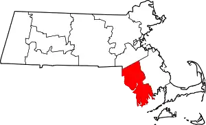 | |
| Towns | ||
| CDPs | ||
| Other villages | ||
| Ghost town | ||
| ||