North Buton Regency
North Buton Regency (Kabupaten Buton Utara) is a regency of Indonesia's Southeast Sulawesi Province, which was separated from Buton Regency in accordance with Indonesia's Law Number 14 of 2007. The area of the regency, which covers the north part of Buton Island, is 1,923.03 km2. Its population at the 2010 Census was 54,736, and according to the latest official estimate (for 2015) is 59,779. The principal town lies at Buranga.[1]
North Buton Regency
Kabupaten Buton Utara | |
|---|---|
 Coat of arms | |
| Motto(s): Lipu Tinadeakono Sara | |
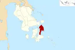 Location within Southeast Sulawesi | |
| Coordinates: 4°46′48″S 122°58′53″E | |
| Country | Indonesia |
| Province | Southeast Sulawesi |
| Capital | Buranga |
| Government | |
| • Regent | Abu Hasan |
| • Vice Regent | Romadio |
| Area | |
| • Total | 1,923.03 km2 (742.49 sq mi) |
| Population (2015) | |
| • Total | 59,779 |
| • Density | 31/km2 (81/sq mi) |
| Time zone | UTC+8 (ICST) |
| Area code | (+62) 403 |
| Website | butonutarakab |

Administration
North Buton Regency was divided at 2010 into six districts (kecamatan), tabulated below with their areas, their 2010 Census populations[2] and the latest (2015) official estimates.[3]
| Name | Area in km2 | Population Census 2010 | Population Census 2015 |
|---|---|---|---|
| Kambowa | 303.44 | 6,224 | 6,778 |
| Bonegunu | 491.44 | 7,727 | 8,417 |
| Kulisusu Barat (West Kulisusu) | 370.47 | 5,823 | 6,252 |
| Kulisusu | 172.78 | 20,652 | 22,688 |
| Kulisusu Utara (North Kulisusu) | 339.64 | 7,797 | 8,405 |
| Wakorumba | 245.26 | 6,513 | 7,239 |
Note that five other administrative districts (kecamatan) which lie geographically on the west coast of North Buton - Pasir Putih, Pasi Kolaga, Wakorumba Selatan (South Wakorumba), Batukara and Maligano - with a combined area of 400.78 km2 and a population of 19,488 at the 2010 Census), are administratively part of Muna Regency.
Climate
Buranga, the regency seat has a tropical savanna climate (Aw) with moderate to little rainfall from July to November and heavy rainfall from December to June.
| Climate data for Buranga | |||||||||||||
|---|---|---|---|---|---|---|---|---|---|---|---|---|---|
| Month | Jan | Feb | Mar | Apr | May | Jun | Jul | Aug | Sep | Oct | Nov | Dec | Year |
| Average high °C (°F) | 30.8 (87.4) |
30.6 (87.1) |
30.9 (87.6) |
31.0 (87.8) |
30.7 (87.3) |
30.2 (86.4) |
29.7 (85.5) |
30.1 (86.2) |
30.7 (87.3) |
31.6 (88.9) |
32.1 (89.8) |
31.3 (88.3) |
30.8 (87.5) |
| Daily mean °C (°F) | 27.2 (81.0) |
27.0 (80.6) |
27.1 (80.8) |
27.3 (81.1) |
27.1 (80.8) |
26.7 (80.1) |
26.0 (78.8) |
26.0 (78.8) |
26.3 (79.3) |
27.1 (80.8) |
28.0 (82.4) |
27.6 (81.7) |
27.0 (80.5) |
| Average low °C (°F) | 23.7 (74.7) |
23.5 (74.3) |
23.4 (74.1) |
23.6 (74.5) |
23.5 (74.3) |
23.2 (73.8) |
22.3 (72.1) |
21.9 (71.4) |
22.0 (71.6) |
22.6 (72.7) |
23.9 (75.0) |
23.9 (75.0) |
23.1 (73.6) |
| Average rainfall mm (inches) | 198 (7.8) |
192 (7.6) |
193 (7.6) |
279 (11.0) |
301 (11.9) |
192 (7.6) |
111 (4.4) |
34 (1.3) |
22 (0.9) |
47 (1.9) |
86 (3.4) |
152 (6.0) |
1,807 (71.4) |
| Source: Climate-Data.org[4] | |||||||||||||
References
- "Kemendagri Tegaskan Buranga Ibu Kota Buton Utara". September 25, 2011. Archived from the original on April 7, 2012.
- Biro Pusat Statistik, Jakarta, 2011.
- Badan Pusat Statistik, Jakarta, 2016.
- "Climate: Buranga". Climate-Data.org. Retrieved 21 November 2020.
Regencies and cities of Southeast Sulawesi | ||
|---|---|---|
Capital: Kendari | ||
| Regencies | ||
| Cities | ||
