Ordnance, Oregon
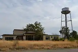
Ordnance is a ghost town in Umatilla County, Oregon, United States, southwest of Hermiston on Interstate 84/U.S. Route 30, near the intersection with Interstate 82. In 1941, the United States Department of War commissioned the establishment of Umatilla Ordnance Depot in northern Umatilla County;[1] it was later renamed Umatilla Army Depot and then Umatilla Chemical Depot. The town was named after the depot, and Ordnance post office was established in 1943. By the 1960s, Ordnance was no longer a community.[2]
Ordnance | |
|---|---|
 | |
 Ordnance Location within the state of Oregon | |
| Coordinates: 45°47′48″N 119°25′01″W | |
| Country | United States |
| State | Oregon |
| County | Umatilla |
| Elevation | 587 ft (179 m) |
| Time zone | UTC-8 (Pacific (PST)) |
| • Summer (DST) | UTC-7 (PDT) |
| ZIP codes | 97882 |
| Area code(s) | 541 |
| GNIS feature ID | 1136600 |
See also
References
- McArthur, Lewis A.; McArthur, Lewis L. (2003) [1928]. Oregon Geographic Names (7th ed.). Portland, Oregon: Oregon Historical Society Press. p. 725. ISBN 978-0875952772.
- Fuzi, Donna (April 8, 1999). "Oral history". Center for Columbia River History. Retrieved October 16, 2011.
External links
- Historic photo of the Umatilla Ordnance Depot from the Oregon Historical Society
- History of the depot from the Center for Columbia River History
Municipalities and communities of Umatilla County, Oregon, United States | ||
|---|---|---|
| Cities | 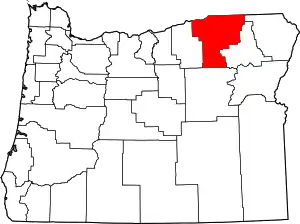 Umatilla County map | |
| CDPs | ||
| Other unincorporated communities | ||
| Indian reservation | ||
| Ghost towns | ||
| ||
This article is issued from Wikipedia. The text is licensed under Creative Commons - Attribution - Sharealike. Additional terms may apply for the media files.
