Nye, Oregon
Nye is an unincorporated community in Umatilla County, Oregon, United States.[1] It is about 8 miles (13 km) west of Pilot Rock, at the junction of U.S. Route 395 and Oregon Route 74.[2][3]
Nye, Oregon | |
|---|---|
 Nye, Oregon Location within the state of Oregon | |
| Coordinates: 45°27′37″N 118°58′48″W | |
| Country | United States |
| State | Oregon |
| County | Umatilla |
| Elevation | 2,310 ft (700 m) |
| Time zone | UTC-8 (Pacific (PST)) |
| • Summer (DST) | UTC-7 (PDT) |
| Area code(s) | 458 and 541 |
| GNIS feature ID | 1136587[1] |
| Coordinates and elevation from Geographic Names Information System | |
Nye was named for A. W. Nye, an early resident of Umatilla County.[4] Nye post office ran from 1887 through 1917.[4]
See also
References
- "Nye". Geographic Names Information System. United States Geological Survey. November 28, 1980. Retrieved December 24, 2010.
- Oregon Atlas & Gazetteer (7th ed.). Yarmouth, Maine: DeLorme. 2008. p. 74. ISBN 0-89933-347-8.
- Writers' Program of the Work Projects Administration in the State of Oregon (1940). Oregon: End of the Trail. American Guide Series. Portland, Oregon: Binfords & Mort. p. 418. OCLC 4874569.
- McArthur, Lewis A.; McArthur, Lewis L. (2003) [1928]. Oregon Geographic Names (7th ed.). Portland, Oregon: Oregon Historical Society Press. p. 711. ISBN 978-0875952772.
Municipalities and communities of Umatilla County, Oregon, United States | ||
|---|---|---|
| Cities | 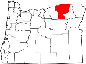 Umatilla County map | |
| CDPs | ||
| Other unincorporated communities | ||
| Indian reservation | ||
| Ghost towns | ||
| ||
This article is issued from Wikipedia. The text is licensed under Creative Commons - Attribution - Sharealike. Additional terms may apply for the media files.
