Pınarbaşı, Kastamonu
Pınarbaşı, formerly Tekkeşin, is a town and district of the Kastamonu Province in the Black Sea region of Turkey. According to the 2000 census, population of the district is 5,978 of which 2,270 live in the town of Pınarbaşı.[3][4] The district covers an area of 513 km2 (198 sq mi),[5] and the town lies at an elevation of 742 m (2,434 ft).
Pınarbaşı | |
|---|---|
District | |
 Location of Pınarbaşı within Turkey. | |
 Pınarbaşı Location of Pınarbaşı | |
| Coordinates: 41°36′N 33°07′E | |
| Country | |
| Region | Black Sea |
| Province | Kastamonu |
| Government | |
| • Mayor | Mehmet Yılmaz (AKP) |
| Area | |
| • District | 513.38 km2 (198.22 sq mi) |
| Elevation | 742 m (2,434 ft) |
| Population (2012)[2] | |
| • Urban | 1,889 |
| • District | 5,101 |
| • District density | 9.9/km2 (26/sq mi) |
| Time zone | UTC+2 (EET) |
| • Summer (DST) | UTC+3 (EEST) |
| Postal code | 37xxx |
| Area code(s) | 366 |
| Licence plate | 37 |
| Climate | Cfb |
| Website | www.pinarbasi-bld.com |
Image gallery
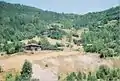 Traditional Turkish houses near Ilısu village at Küre mountains, Pınarbaşı
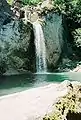 Ilısu Waterfall at Küre Mountains National Park, near Pınarbaşı
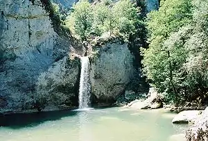 Ilısu Waterfall
See also
Notes
- "Area of regions (including lakes), km²". Regional Statistics Database. Turkish Statistical Institute. 2002. Retrieved 2013-03-05.
- "Population of province/district centers and towns/villages by districts - 2012". Address Based Population Registration System (ABPRS) Database. Turkish Statistical Institute. Retrieved 2013-02-27.
- Turkish Statistical Institute. "Census 2000, Key statistics for urban areas of Turkey" (XLS) (in Turkish). Retrieved 2008-11-01.
- GeoHive. "Statistical information on Turkey's administrative units". Retrieved 2008-11-28.
- Statoids. "Statistical information on districts of Turkey". Retrieved 2008-11-28.
References
- Falling Rain Genomics, Inc. "Geographical information on Pınarbaşı, Turkey". Retrieved 2008-11-01.
External links
- District governor's official website (in Turkish)
- District municipality's official website (in Turkish)
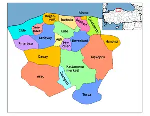
Pınarbaşı, Kastamonu in Kastamonu Province of Turkey | |||||||||||||||||||||||||||
|---|---|---|---|---|---|---|---|---|---|---|---|---|---|---|---|---|---|---|---|---|---|---|---|---|---|---|---|
| Districts | Districts of Kastamonu | ||||||||||||||||||||||||||
| |||||||||||||||||||||||||||
Metropolitan municipalities are bolded. | |||||||||||||||||||||||||||
This article is issued from Wikipedia. The text is licensed under Creative Commons - Attribution - Sharealike. Additional terms may apply for the media files.