Petrolia, Pennsylvania
Petrolia is a borough in Butler County, Pennsylvania, United States. The population was 212 at the 2010 census.[3]
Petrolia, Pennsylvania | |
|---|---|
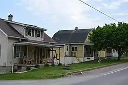 Neighborhood on Argyle Street | |
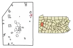 Location of Petrolia in Butler County, Pennsylvania. | |
 Petrolia Location of Petrolia in Butler County, Pennsylvania. | |
| Coordinates: 41°01′05″N 79°43′06″W | |
| Country | United States |
| State | Pennsylvania |
| County | Butler |
| Settled | 1872 |
| Incorporated | 1873 |
| Government | |
| • Type | Borough Council |
| Area | |
| • Total | 0.40 sq mi (1.02 km2) |
| • Land | 0.40 sq mi (1.02 km2) |
| • Water | 0.00 sq mi (0.00 km2) |
| Elevation | 1,178 ft (359 m) |
| Population (2010) | |
| • Total | 212 |
| • Estimate (2019)[2] | 198 |
| • Density | 501.27/sq mi (193.65/km2) |
| Time zone | UTC-5 (Eastern (EST)) |
| • Summer (DST) | UTC-4 (EDT) |
| Zip code | 16050 |
| FIPS code | 42-59672 |
Geography
Petrolia is located in eastern Butler County at 41°1′5″N 79°43′6″W (41.017964, -79.718204),[4] in the valley of the South Branch of Bear Creek, a tributary of the Allegheny River.
Pennsylvania Route 268 passes through the borough, leading north 3 miles (5 km) to Bruin and south 1.7 miles (2.7 km) to Karns City.
According to the United States Census Bureau, Petrolia has a total area of 0.39 square miles (1.0 km2), all of it land.[3]
Demographics
| Historical population | |||
|---|---|---|---|
| Census | Pop. | %± | |
| 1880 | 1,186 | — | |
| 1890 | 546 | −54.0% | |
| 1900 | 350 | −35.9% | |
| 1910 | 360 | 2.9% | |
| 1920 | 370 | 2.8% | |
| 1930 | 469 | 26.8% | |
| 1940 | 559 | 19.2% | |
| 1950 | 571 | 2.1% | |
| 1960 | 527 | −7.7% | |
| 1970 | 432 | −18.0% | |
| 1980 | 472 | 9.3% | |
| 1990 | 292 | −38.1% | |
| 2000 | 218 | −25.3% | |
| 2010 | 212 | −2.8% | |
| 2019 (est.) | 198 | [2] | −6.6% |
| Sources:[5][6][7] | |||
As of the census[6] of 2000, there were 218 people, 89 households, and 64 families residing in the borough. The population density was 543.7 people per square mile (210.4/km2). There were 99 housing units at an average density of 246.9 per square mile (95.6/km2). The racial makeup of the borough was 100.00% White.
There were 89 households, out of which 29.2% had children under the age of 18 living with them, 53.9% were married couples living together, 11.2% had a female householder with no husband present, and 27.0% were non-families. 20.2% of all households were made up of individuals, and 6.7% had someone living alone who was 65 years of age or older. The average household size was 2.45 and the average family size was 2.80.
In the borough the population was spread out, with 21.1% under the age of 18, 8.3% from 18 to 24, 34.4% from 25 to 44, 23.9% from 45 to 64, and 12.4% who were 65 years of age or older. The median age was 38 years. For every 100 females there were 89.6 males. For every 100 females age 18 and over, there were 93.3 males.
The median income for a household in the borough was $29,821, and the median income for a family was $37,708. Males had a median income of $31,875 versus $23,750 for females. The per capita income for the borough was $17,358. About 8.5% of families and 14.5% of the population were below the poverty line, including 23.1% of those under the age of eighteen and none of those sixty five or over.
Education
- Karns City Area School District - public school
- Karns City High School
References
- "2019 U.S. Gazetteer Files". United States Census Bureau. Retrieved July 28, 2020.
- "Population and Housing Unit Estimates". United States Census Bureau. May 24, 2020. Retrieved May 27, 2020.
- "Geographic Identifiers: 2010 Demographic Profile Data (G001): Petrolia borough, Pennsylvania". U.S. Census Bureau, American Factfinder. Archived from the original on February 12, 2020. Retrieved March 25, 2014.
- "US Gazetteer files: 2010, 2000, and 1990". United States Census Bureau. 2011-02-12. Retrieved 2011-04-23.
- "Census of Population and Housing". U.S. Census Bureau. Retrieved 11 December 2013.
- "U.S. Census website". United States Census Bureau. Retrieved 2008-01-31.
- "Incorporated Places and Minor Civil Divisions Datasets: Subcounty Resident Population Estimates: April 1, 2010 to July 1, 2012". Population Estimates. U.S. Census Bureau. Archived from the original on 17 June 2013. Retrieved 11 December 2013.
| Counties |  Map of the Pittsburgh Tri-State with green counties in the metropolitan area and yellow counties in the combined area | |
|---|---|---|
| Major cities | ||
| Cities and towns 15k–50k (in 2010) | ||
| Airports | ||
| Topics | ||
| ||
Municipalities and communities of Butler County, Pennsylvania, United States | ||
|---|---|---|
| City |  | |
| Boroughs | ||
| Townships | ||
| CDPs | ||
| Unincorporated communities | ||
| Footnotes | ‡This populated place also has portions in an adjacent county or counties | |
| ||
| Authority control |
|
|---|