Pico Island
Pico Island (Ilha do Pico, Portuguese pronunciation: [ˈiʎɐ du ˈpiku]), is an island in the Central Group of the Portuguese Azores. The landscape features an eponymous volcano, Ponta do Pico, which is the highest mountain in Portugal, the Azores, and the highest elevation of the Mid-Atlantic Ridge. In the tradition of the Portuguese poet, Raul Brandão, Pico is referred to as the Ilha Preta ("Black Island"), for its black volcanic earth, responsible for its UNESCO-designated historical vineyards that allowed the development of the island. Geologically speaking, Pico is the most recently formed island of the Azores, with around 300,000 years.[3]
| Native name: Ilha do Pico Nickname: The Black Island | |
|---|---|
.jpg.webp) The island of Pico, as seen from the north-west coast in the outskirts of Madalena with vineyards and Mount Pico in the background | |
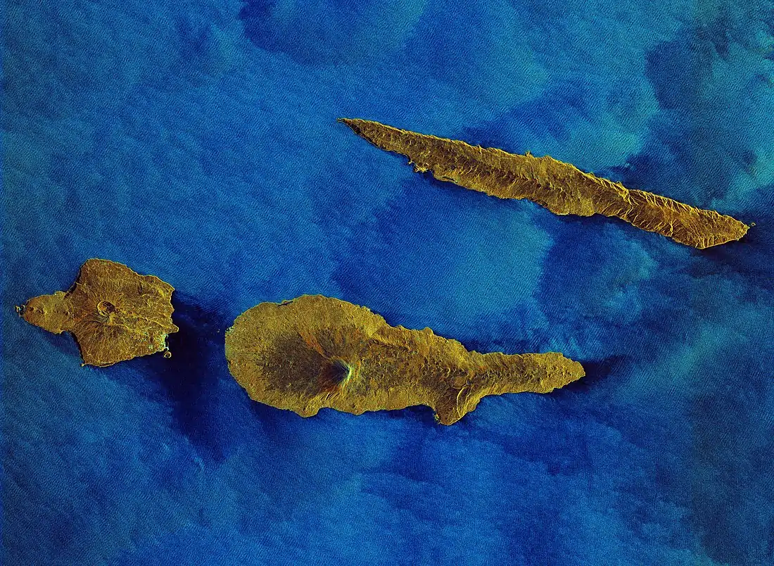
 Location of the island of Pico in the archipelago of the Azores | |
| Geography | |
| Location | Atlantic Ocean |
| Coordinates | 38°27′57″N 28°20′0″W |
| Archipelago | Azores |
| Area | 444.97 km2 (171.80 sq mi)[1] |
| Coastline | 151.84 km (94.349 mi)[1] |
| Highest elevation | 2,351 m (7713 ft)[1] |
| Highest point | Mount Pico |
| Administration | |
| Autonomous Region | Azores |
| Municipalities | |
| Demographics | |
| Demonym | Picoense |
| Population | 13,645 (2019)[2] |
| Pop. density | 30.66/km2 (79.41/sq mi) |
| Languages | Portuguese |
| Ethnic groups | Portuguese |
| Additional information | |
| Time zone | |
History
Although the Azores have been inhabited since 1439, settlement on Pico only started in the 1480s, precisely when Pico became an integral part of the captaincy of the neighboring island of Faial. Pico is thought to be the last of the islands of the Central Group to be occupied.[4]
The first settlement, Lajes do Pico, had the contribution of settlers of Portuguese origin, from different parts of the metropolis, who probably would have already been on Madeira Island or even on the previously populated Azorean islands, namely in Terceira. This included different social groups: individuals belonging to a small nobility, who are distinguished by the possession of land and lifestyle; secular and regular clergy, of which the Franciscan presence stands out; and a third group, divided between merchants, craftsmen, rural workers and artisans. Besides these, other minorities such as jews, proven present since the beginning of the 16th century, and slaves, oriented towards rural and domestic work, constituted the island's first inhabitants.[4]
In the mid 16th century, a new area to the north of the island became equally attractive to new settlers. Thus, in 1542, the inhabitants of this area asked King João III to create a second village on the island, due to it being barely provided of justice, which led people stealing and profiting off others, and so São Roque do Pico was created.[4]
The last eruptions of the island took place 1718 and 1720 and generated three volcanic cinder cones (Mistérios): Santa Luzia and São João in 1718[5] and Silveira in 1720.[6]
In 1723, Madalena was elevated to the status of "town", confirming its economic importance to the island, and its commercial links to Faial (Horta had been the residence of many of the island's property-owners and winemakers).
Its settlers were initially occupied with wheat cultivation in addition to the exploration of the woad industry (based on lichens that were exported to Flanders to produce commercial dyes), and heavily influenced by export industries of its island neighbor, Faial.[7]
Quickly, the viticulture industry, helped by the rich soils and micro-climates, had allowed to expand the lands cultivating grapes. Its development would occur uninterrupted along the margins of history except for volcanic eruptions during the 18th century; the viticulture and "orange cycle" would expand the activities on the island throughout the period. Pico's famous verdelho, for more than two centuries, was appreciated in many countries (including England and in the Americas and even reached the palaces of the Russian czars). But, the spread of powdery mildew and phylloxera during the middle of the 19th century destroyed many of the vineyards, creating a crisis on the island that lasted until the 20th century.[7]
The presence of American and British whalers in the waters of the Azores at the end of the 18th century introduced a new economy that would serve to stabilize the economy until new casts were introduced on the island. Spermwhale hunting became the primary industry around the island until it was abolished in 1986. The previous whale factory was rebuilt into a museum.[8][7]
Geography
Physical geography
.jpg.webp)
.jpg.webp)
%252C_Pico_Island%252C_Azores%252C_Portugal_(PPL1-Corrected)_5_julesvernex2.jpg.webp)
The island is 17.5 km south of São Jorge and just 7 km east of Faial, in the Central Group of islands, an area that is colloquially known as o Triangulo (The Triangle). Pico is 46 kilometers long, and at its maximum extent about 16 kilometers wide, rising from its center to the west in the summit of the stratovolcano of Pico; making it the second largest of the Azores islands. Along the central plain of volcano cones to the eastern coast, the landscape is pitted with the remnants of craters and lake-filled cones, and dominated by the ancient volcano of Topo. Geomorphologically, the island is composed of three units:
- Topo Volcano - Located on the southeastern coast, it corresponds to an ancient volcano destroyed by erosion and landslides;
- Plain of Achada - Extending from Topo to the stratovolcano, the Achada Plain is an axial zone comprising spatter and lava cones along a mountainous ridge filled with lake-filled craters, dense scrub and forests. Cones in this region are oriented along a west-northwest and south-southeast axis along a path east to west between the other volcanic structures;
- Pico Volcano - It occupies the western portion of the island, and corresponds to the central volcano with a 2,341-metre (7,680 ft) altitude. Along its flanks are diverse lava and spatter cones that are formed along radial fractures and faults.
Generally, the island of Pico's tectonic structures are oriented along a west-northwest to east-southeast and a northeast to southwest axis. The main axis controls the main structures, especially the main mountain of Pico, while the secondary axises affect the radial fractures and faults along the central plain and eastern volcano.
Similar to the geomorphological structures described above, the volcanic landforms have been identified by Madeira (1998) in the following units:
- Volcanic Complex of Lajes - pertains to the oldest volcanic structures, comprising volcanoes, lavas and debris that are between 35 and 300,000 thousand years old; it makes up the structures of the eastern part of the island, including the ancient volcano of Topo.
- Volcanic Complex of Calheta de Nesquim - dating to about 230,000 thousand years ago, this is a fissural zone of cones and basaltic lavas, associated with the Achada Plain, and the many faults along the central plateau of the island.
- Volcanic Complex of Madalena - the most recent volcanic complex, with both geological and historical eruptions; it includes the basaltic stratovolcano of Pico, but also many of the cones, faults and lava fields that circle the 2,351 meter summit.
The last volcanic eruption (which is debatable) occurred in 1963, in a small submarine eruption off the northwest coast (north of Cachorro in Santa Luzia). Prior to this, major volcanic activity was evident in lava fields generated in only the areas of Prainha (1562–64), Santa Luzia (1718), São João (1718) and Silveira (1720). The paths of the lava flows are still visible; those in the 16th century and 1718 were particularly substantial, extending for over 10 km. Today, the only visible evidence of active volcanism appears on the summit of Pico, in the base and interior of the Piqueninho (the mini-peak on the summit); there are irregular emissions from cracks in this zone. Additionally, there are emissions on the eastern flanks between 1500 and 2000 meters altitude. There have also been found areas of de-gasification along the fault associated with the Lagoa do Capitão and another in the Topo Volcano, as well as a spring rich in CO2 in the area of Silveira.
Pico, much like the other islands, is susceptible to seismic events, although their epicenters have primarily been localized in the Faial-Pico or Pico-São Jorge Channels. The strongest earthquake registered in the last 30 years occurred on July 9, 1998, and had its epicenter 5 kilometers northeast of Ponta da Ribeirinha, on the island of Faial, reaching a 5.8 magnitude. It was felt on Pico, with a maximum intensity level of VII on the Mercalli scale; some homes were damaged and possessions were buffeted. Other violent earthquakes which have affected the island include: the 1957-58 seismic events associated with the eruption of the Capelinhos volcano (on Faial), the February 1964 earthquake on the island of São Jorge, and the 1926 earthquake, whose epicenter was registered in the Faial-Pico Channel.
Climate

Due to its topographic variation, the island has dramatic temperature and precipitation fluctuations.
At lower elevations, where most of the population resides, Pico has a humid subtropical climate (Köppen: Cfa) with very mild, rainy winters and warm, noticeably drier summers, although generally not dry enough to be classified as Mediterranean. It has an average temperature of 17.5–18 °C (63.5–64.4 °F) and around 1,000 mm (39 in) of precipitation falls each year though it can reach values as high as 2,000 mm (79 in) on the northeast coast (mainly on Prainha and Santo Amaro).[9] Because of its high relative humidity (around 80%), summers can feel slightly warmer than they really are.[10][11]
At higher elevations, temperatures are cooler and precipitation increases, it therefore transitions into an oceanic climate, average relative humidity stays around 90%.[10] Places such as the Caiado and Paul lagoons receive, respectively, 4,698 and 3,357 millimetres (185.0 and 132.2 in)[12] of precipitation each year though Mount Pico is recognized as receiving the largest annual rainfall in Portugal (over 6,250 mm (246 in) per year at the base of the volcano).
As altitude reaches 1,500 metres (4,900 ft) and exceeds the planetary boundary layer, both precipitation and humidity levels decrease reaching the top of the volcano which averages only around 500 millimetres (20 in) of precipitation. Temperatures at the peak of the stratovolcano (2,300 metres (7,500 ft) a.s.l.) average 4 °C (39 °F) and snow can be occasionally seen in the cooler months, one of the few places in the archipelago where this phenomenon is possible.[9] The climate at this altitude is now subpolar oceanic (Cfc).
| Climate data for Madalena, Pico Island, Azores | |||||||||||||
|---|---|---|---|---|---|---|---|---|---|---|---|---|---|
| Month | Jan | Feb | Mar | Apr | May | Jun | Jul | Aug | Sep | Oct | Nov | Dec | Year |
| Average high °C (°F) | 16.6 (61.9) |
16.2 (61.2) |
16.7 (62.1) |
17.6 (63.7) |
19.3 (66.7) |
21.6 (70.9) |
24.1 (75.4) |
25.3 (77.5) |
24.2 (75.6) |
21.6 (70.9) |
19.1 (66.4) |
17.5 (63.5) |
20.0 (68.0) |
| Daily mean °C (°F) | 14.5 (58.1) |
13.9 (57.0) |
14.4 (57.9) |
15.2 (59.4) |
16.7 (62.1) |
19.0 (66.2) |
21.3 (70.3) |
22.4 (72.3) |
21.4 (70.5) |
19.2 (66.6) |
16.9 (62.4) |
15.4 (59.7) |
17.5 (63.5) |
| Average low °C (°F) | 12.4 (54.3) |
11.7 (53.1) |
12.2 (54.0) |
12.8 (55.0) |
14.2 (57.6) |
16.4 (61.5) |
18.5 (65.3) |
19.6 (67.3) |
18.7 (65.7) |
16.8 (62.2) |
14.8 (58.6) |
13.4 (56.1) |
15.1 (59.2) |
| Average rainfall mm (inches) | 109.5 (4.31) |
113.8 (4.48) |
97.0 (3.82) |
68.1 (2.68) |
77.0 (3.03) |
35.9 (1.41) |
31.2 (1.23) |
63.0 (2.48) |
91.4 (3.60) |
130.6 (5.14) |
147.3 (5.80) |
144.2 (5.68) |
1,109 (43.66) |
| Source 1: climate-data.org[13] | |||||||||||||
| Source 2: IPMA (precipitation)[12] | |||||||||||||
| Jan | Feb | Mar | Apr | May | Jun | Jul | Aug | Sep | Oct | Nov | Dec | Year |
|---|---|---|---|---|---|---|---|---|---|---|---|---|
| 16.4 °C (61.5 °F) | 15.9 °C (60.6 °F) | 15.7 °C (60.3 °F) | 16.2 °C (61.2 °F) | 17.4 °C (63.3 °F) | 19.2 °C (66.6 °F) | 21.9 °C (71.4 °F) | 23.9 °C (75.0 °F) | 23.1 °C (73.6 °F) | 20.6 °C (69.1 °F) | 18.4 °C (65.1 °F) | 17.1 °C (62.8 °F) | 18.8 °C (65.8 °F) |
Human geography
The main settlements are Madalena, São Roque do Pico and Lajes do Pico; the total population is 15,761 inhabitants (as of 2007).
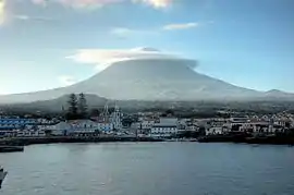 The village of Madalena at the western base of Mount Pico, as seen from the Faial-Pico Channel
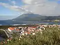 Lajes do Pico, along the south-central coast, with Mount Pico in the distance
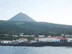 The port and historic centre of the civil parish of São Roque, showing the whaling museum, and former rendering factory along the coast
Economy

The island supported a substantial whaling industry until 1980. The position of the island on the Mid-Atlantic Ridge means that deep water is very close. Active industries include tourism, shipbuilding and wine production. Landscape of the Pico Island Vineyard Culture has been a UNESCO World Heritage Site since 2004. It has several notable wines that are commercialized in Portugal and exported abroad.
Sustainable tourism
In 2012, Pico received the QualityCoast Gold Award for its efforts to become a sustainable tourism destination. Because of this award, Pico has been selected for inclusion in the global atlas for sustainable tourism DestiNet.[15]
Gallery
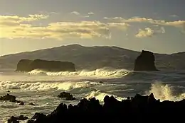
.jpg.webp) Black sand beach of Canto da Areia
Black sand beach of Canto da Areia Grotões Lagoon
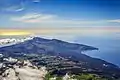 East side of the island, viewed from Mount Pico
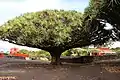 Old Dracaena draco near Pico's Wine Museum
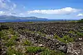
References
Notes
- "Geografia Pico". iaram.azores.gov.pt. Azores Government. Retrieved 11 January 2021.
- "Average Population Estimates". srea.azores.gov.pt. Retrieved 11 January 2021.
- "Formação e principais erupções". azoresgreenmark.com. Retrieved 11 January 2021.
- "Pico Island Discovery and Settlement". iac-azores.org. Retrieved 11 January 2021.
- "Vulcão do Pico". ivar.azores.gov.pt. Retrieved 11 January 2021.
- "Sistema Vulcânico Fissural do Pico". ivar.azores.gov.pt. Retrieved 11 January 2021.
- "Pico História". visitazores.com. Retrieved 11 January 2021.
- "Baleeiros açorianos: a história que não se repete". RTP. Retrieved 11 January 2021.
- Azevedo, Eduardo. (2014). "CLIMATE OVERVIEW - in: PICO ISLAND NATURAL HISTORY HANDBOOK". ResearchGate. Retrieved 6 December 2020.
- "Caracterização e Diagnóstico da Ilha do Pico" (PDF). servicos-sraa.azores.gov.pt. Retrieved August 4, 2020.
- "Clima e Diferenciação Climática das Ilhas dos Açores" (PDF). www.climaat.angra.uac.pt. Retrieved August 4, 2020.
- "Atlas Climático Ibérico" (PDF). IPMA, AEMET. Retrieved 6 December 2020.
- "Climate: São Roque do Pico". Retrieved 2020-08-04.
- "São Roque do Pico Sea Temperature". Retrieved 2020-08-19.
- "Sustainable Tourism Destination EUCC" (PDF). Archived from the original (PDF) on 2016-09-18. Retrieved 2013-04-02.
Sources
- Scarth, Alwyn; Tanguy, Jean-Claude (2001), Volcanoes of Europe, Oxford University Press, p. 243, ISBN 0-19-521754-3
- Nunes, J.C. (1999), A actividade vulcânica na ilha do Pico do Plistocénio Superior ao Holocénio: Mecanismo eruptivo e hazard vulcânico. Tese de doutoramento no ramo de Geologia, especialidade de Vulcanologia, Ponta Delgada: University of the Azores, p. 357
- Madeira, José Eduardo de Oliveira (1998), Estudos de neotectónica nas ilhas do Faial, Pico e S. Jorge: uma contribuição para o conhecimento geodinâmico da junção tripla dos Açores. Tese de Doutoramento no ramo de Geologia, especialidade em Geodinâmica Interna, Lisbon: Faculty of Sciences, University of Lisbon, p. 428
- Madeira, José Eduardo de Oliveira; António Brum da Silveira (October 2003), Active tectonics and first paleoseismological results in Faial, Pico and S. Jorge islands (Azores, Portugal), 5, 46, Lisbon: Annals of Geophysics, pp. 733–761
- Senos, M.L.; Gaspar, João Luís; Ferreira, Teresa; Cruz, L.; Nunes, J.C.; Pacheco, J. (1998), O terramoto do Faial de 9 de Julho de 1998, Proceedings do 1º Simpósio de Meterologia e Geofísica da AMPG, pp. 61–68
External links
| Wikisource has the text of the 1911 Encyclopædia Britannica article Pico. |
- Pico - A Ilha Montanha Atlantica, a Flickr Group with images of the island
- The Azores Islands Blogspot, with information on the Azores and Pico Island
- A Pico hike and trip report (September 2007)
- Visit Pico
| Grupo Oriental (Eastern Group) |  | |
|---|---|---|
| Grupo Central (Central Group) | ||
| Grupo Ocidental (Western Group) | ||
| Islets | ||
| Caves and geological features | ||
| Reefs, banks and seamounts | ||
| Norte |
| Flag of Portugal |
|---|---|---|
| Centro | ||
| Lisboa |
| |
| Alentejo |
| |
| Azores |
| |
| Madeira | ||
