Peñón de Vélez de la Gomera
Peñón de Vélez de la Gomera (Spanish pronunciation: [peˈɲon de ˈβeleθ ðe la ɣoˈmeɾa]; Arabic: حجر بديس, romanized: Hajar Badis) is a Spanish exclave and rocky tied island, in the western Mediterranean Sea, connected to the Moroccan shore by a sandy isthmus. It is also connected to a smaller islet to the east, La Isleta, by a rocky isthmus. The tied island was named Hajar Badis (Rock of Badis) and was connected to the town of Badis.
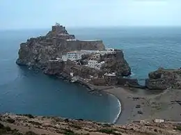 Peñón de Vélez de la Gomera, seen from the Moroccan coast in 2007. | |
| Geography | |
|---|---|
| Location | Moroccan coast |
| Coordinates | 35°10′20″N 4°17′59″W |
| Adjacent bodies of water | Mediterranean Sea |
| Area | 1.9 ha (4.7 acres) |
| Administration | |
| Plazas de soberania | |
Vélez de la Gomera, along with La Isleta, is a Plaza de soberanía, a premodern overseas possession, administered by the Spanish central government,[1] and has a population consisting only of a small number of Spanish military personnel.
Geography

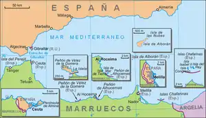
Peñón de Vélez de la Gomera is located 119 km (73.94 mi) southeast of Ceuta. It was a natural island in the Alboran Sea until 1934, when a huge thunderstorm washed large quantities of sand in the short channel between the island and the African continent, turning it into a tombolo.[2] Ever since, it has been a peninsula, currently connected to the Moroccan coast by an 85 m (278.87 ft) long sandy isthmus, the world's shortest single land-border segment.[3] With a length of 400 m (1,312.34 ft) northwest-southeast and a width of up to 100 m (328.08 ft), it covers about 19,000 m2 or 1.9 ha.
History
Portugal and Spain passed an agreement in 1496 in which they effectively established their zones of influence on the North African coast: Spain could only occupy territory east of Peñón de Vélez. This restriction only ended with the Iberian Union of Portugal and Spain under Felipe II after the 1578 Battle of Alcácer Quibir, when Spain started to take direct actions in Morocco, as in the occupation of Larache.[4]
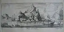
In 1508, Spain launched a successful expedition under the command of Pedro Navarro to take the Peñón located near Badis, held by pirates who were constantly attacking and looting the coast of Southern Spain.
In 1522, Spain lost the Peñón to a Moroccan Berber attack that resulted in the deaths of the whole Spanish garrison. Ali Abu Hassun, new Wattasid ruler of Morocco in 1554, then gave the Peñón to Ottoman troops who had assisted him in gaining the throne.[4]
The Ottomans used it as a base for corsairs operating in the region of the Strait of Gibraltar. When the Saadid sultan Abdallah al-Ghalib was alarmed by this activity, and feared that the Ottomans might use the town of Badis as a base from which to undertake the conquest of Morocco. In 1564, he forced the Moroccans to evacuate the town and the Peñón, which he handed over to the Spaniards. The Moroccan population retired to the kasba of Senada.[5]
In 2012, the territory was occupied by a group of Moroccan self-proclaimed activists belonging to the Committee for the Liberation of Ceuta and Melilla, whose leader was Yahya Yahya.[6]
Transportation
The territory is reached mostly by helicopter via a helipad located on the upper sections. A landing area is located on the south end near the land entrance to Peñón de Vélez de la Gomera.
See also
References
- González, Mónica Ceberio Belaza, Ignacio Cembrero, Miguel (2012-09-17). "The last remains of the Spanish empire". EL PAÍS. Retrieved 2020-07-31.
- "Historia de Peñón de Vélez de la Gomera". Ejercito de Tierra (in Spanish). Archived from the original on 14 May 2009. Retrieved 29 October 2018.
- Lewis, Martin W. (30 Aug 2010). "The World's Shortest Border". GeoCurrents. Archived from the original on 11 August 2018. Retrieved 22 June 2019.
- Kissling, Hans Joachim; Spuler, Bertold; et al. (29 October 1996). The Last Great Muslim Empires: History of the Muslim World. Translated by Bagley, F. R. C. Princeton, New Jersey: Markus Wiener Publishers. p. 103. ISBN 978-1-55876-112-4. Retrieved 29 October 2018 – via Google Books.
- Colin, G.S. (1986) [1960]. "Bādis". In Bearman, P.; Bianquis, Th.; Bosworth, C.E.; van Donzel, E.; Heinrichs, W.P. (eds.). Encyclopaedia of Islam. I (2nd ed.). Leiden, Netherlands: Brill Publishers. p. 859. doi:10.1163/1573-3912_islam_SIM_0995. ISBN 9004081143.
- Sánchez, Paqui (29 August 2012). "Cuatro activistas marroquíes intentan ocupar el Peñón de Vélez de la Gomera". El Mundo (in Spanish).
- "Moroccans eye Spanish enclave across tiny border". The National. July 16, 2017. Retrieved 2020-07-31.
- "Europe :: Spain — The World Factbook - Central Intelligence Agency". www.cia.gov. Retrieved 2020-08-01.
External links
- Spanish Autonomous Communities at WorldStatesmen.org
Countries and territories of North Africa | |||||||||||||||||
|---|---|---|---|---|---|---|---|---|---|---|---|---|---|---|---|---|---|
| Sovereign states | |||||||||||||||||
| Partially recognized state | |||||||||||||||||
| Territories |
| ||||||||||||||||
1Entirely claimed by both Morocco and the SADR. 2Spanish exclaves claimed by Morocco. 3Portuguese archipelago claimed by Spain. 4Disputed between Egypt and the Sudan. 5Terra nullius located between Egypt and the Sudan. 6Disputed between South Sudan and the Sudan. 7Part of Chad, formerly claimed by Libya. 8Disputed between Morocco and Spain | |||||||||||||||||