Pindorama
Pindorama (Portuguese pronunciation: [pĩdoˈɾɐ̃mɐ]) is a municipality in the state of São Paulo, Brazil. The name is Tupi for Land of the Palms, the natives' name for Brazil.
Pindorama | |
|---|---|
 Flag | |
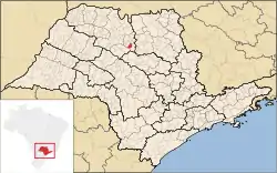 Location in São Paulo state | |
 Pindorama Location in Brazil | |
| Coordinates: 21°11′09″S 48°54′26″W | |
| Country | Brazil |
| Region | Southeast |
| State | São Paulo |
| Mesoregion | São José do Rio Preto |
| Area | |
| • Total | 184.8 km2 (71.4 sq mi) |
| Elevation | 527 m (1,729 ft) |
| Population (2020 [1]) | |
| • Total | 17,216 |
| • Density | 93/km2 (240/sq mi) |
| Time zone | UTC-03:00 (BRT) |
| • Summer (DST) | UTC-02:00 (BRST) |
| Postal code | 15830-000 |
| Area code | +55 17 |
| Website | www |
Location
The population is 17,216 (2020 est.) in an area of 184.8 km².[2] The municipality contains the 533 hectares (1,320 acres) Pindorama Biological Reserve, a strictly protected conservation unit created in 1986 from a former experimental agricultural station.[3] Pindorama belongs to the Mesoregion of São José do Rio Preto.
Economy
The Tertiary sector corresponds to 57.86% of Pindorama's GDP. The Primary sector is 9.45% of the GDP and the Industry corresponds to 32.70%.[4]
References
- IBGE 2020
- Instituto Brasileiro de Geografia e Estatística
- Nogueira Abdo, Maria Teresa Vilela; Valeri, Sergio Valiengo; Ferraudo, Antonio Sergio (2015), "Avaliação do efeito de borda da Reserva Biológica de Pindorama, SP", Revista Verde de Agroecologia e Desenvolvimento Sustentável (in Portuguese), 10 (4): 01, doi:10.18378/rvads.v10i4.3398, retrieved 2016-04-28
- "Municipal Profile at SEADE - Search". SEADE.gov.br. Archived from the original on 23 August 2011. Retrieved 28 July 2011.
This article is issued from Wikipedia. The text is licensed under Creative Commons - Attribution - Sharealike. Additional terms may apply for the media files.
