Guapiaçu
Guapiaçu is a municipality in the state of São Paulo, Brazil, with a population, measured in 2020 by the IBGE, of 21,775 and an area of 326 km2 (126 sq mi). Is located in the north/northwest of the state, 17 kilometres (11 mi) from São José do Rio Preto.
Guapiaçu | |
|---|---|
| Município de Guapiaçu Municipality of Guapiaçu | |
 | |
 Flag  Seal | |
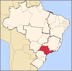
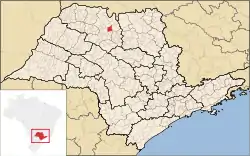 Location of Guapiaçu | |
| Coordinates: 20°47′42″S 49°13′13″W | |
| Country | |
| Region | Southeast |
| State | |
| Mesoregion | São José do Rio Preto |
| Founded | November 30, 1953 |
| Government | |
| • Mayor | Carlos César Zaitune (PMDB) |
| • Vice Mayor | Mauro Ruiz |
| Area | |
| • Total | 326 km2 (126 sq mi) |
| Elevation | 480 m (1,570 ft) |
| Population (2020 [1]) | |
| • Total | 21,775 |
| • Density | 54.8/km2 (142/sq mi) |
| Demonym(s) | Portuguese: Guapiaçuense |
| Time zone | UTC-3 (UTC-3) |
| • Summer (DST) | UTC-2 (UTC-2) |
| Postal Code | 15110-000 |
| Area code(s) | (+55) 17 |
| Website | Guapiaçu's Prefecture |
The city name comes from the Tupi language, and means "Big spring (of a river)".
History
The settlement of the region began at the end of the 19th century. At the beginning of the 20th century, the city was a village named Ribeirão Claro. On 28 November 1927 the village was elevated to a district. The name changed to its current form in 1945. The city was established as a municipality on 30 November 1953, when it was separated from Rio Preto.[2]
Demographics
Indicators
- Population: 17,869 (IBGE/2010)
- Area: 326 km2 (126 sq mi)
- Population density: 54.8/km² (2,451.5/sq mi)
- Urbanization: 88.4% (2010)
- Birth rate: 11.59/1,000 inhabitants (2009)
- Infant mortality: 9.9/1,000 births (2009)
- Literacy rate: 90.26 (2000)
- HDI: 0.817 (UNDP/2000)
Economy
Manufacturing is the economic basis of Guapiaçu, producing 53.2% of the city's GDP. The tertiary sector provides 39.4% of GDP, and the primary sector 7.3%.[3]
Transportation
- SP-425 "Rodovia Assis Chateaubriand", 17 kilometres (11 mi) to São José do Rio Preto
- Estrada Vicinal (Vicinal road) to Cedral
References
- IBGE 2020
- "History of the City of Guapiaçu" (in Portuguese). Guapiacu.sp.gov.br. Retrieved 8 July 2011.
- "Municipal Profile at SEADE" (in Portuguese). SEADE.gov.br. Archived from the original on 23 August 2011. Retrieved 15 July 2011.
- "2010 Census of the IBGE – Population – Table 2.1.20" (PDF) (in Portuguese). IBGE.gov.br. Retrieved 13 July 2011.
Capital: São Paulo | |||||||||||||||||||||
|  | ||||||||||||||||||||
|
| |||||||||||||||||||||
| |||||||||||||||||||||
| |||||||||||||||||||||
| |||||||||||||||||||||
| |||||||||||||||||||||
| |||||||||||||||||||||
| |||||||||||||||||||||
| |||||||||||||||||||||
| |||||||||||||||||||||
| |||||||||||||||||||||
| |||||||||||||||||||||
| |||||||||||||||||||||