Pink Line (Jaipur Metro)
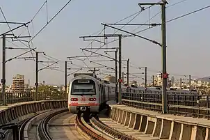
The Pink Line of the Jaipur Metro is part of the rapid transit system in the city of Jaipur, India. It is also called East-West Corridor of Jaipur.[1] It consists of 11 metro stations from Mansarovar in the West to Chaupar in the East. The line with a length of 11.68 kilometers (7.26 mi) is mostly elevated and partially underground and has been laid to connect the oldest part of Jaipur to rest of it.
| Pink Line | ||||||||||||||||||||||||||||||||||||||||||||||||||||||||||||||||||||||||||||||||||||||||||||||||||||||||||||||||||||||||||||
|---|---|---|---|---|---|---|---|---|---|---|---|---|---|---|---|---|---|---|---|---|---|---|---|---|---|---|---|---|---|---|---|---|---|---|---|---|---|---|---|---|---|---|---|---|---|---|---|---|---|---|---|---|---|---|---|---|---|---|---|---|---|---|---|---|---|---|---|---|---|---|---|---|---|---|---|---|---|---|---|---|---|---|---|---|---|---|---|---|---|---|---|---|---|---|---|---|---|---|---|---|---|---|---|---|---|---|---|---|---|---|---|---|---|---|---|---|---|---|---|---|---|---|---|---|
 | ||||||||||||||||||||||||||||||||||||||||||||||||||||||||||||||||||||||||||||||||||||||||||||||||||||||||||||||||||||||||||||
| Overview | ||||||||||||||||||||||||||||||||||||||||||||||||||||||||||||||||||||||||||||||||||||||||||||||||||||||||||||||||||||||||||||
| Owner | Jaipur Metro Rail Corporation LTD. | |||||||||||||||||||||||||||||||||||||||||||||||||||||||||||||||||||||||||||||||||||||||||||||||||||||||||||||||||||||||||||
| Locale | Jaipur, Rajasthan, India | |||||||||||||||||||||||||||||||||||||||||||||||||||||||||||||||||||||||||||||||||||||||||||||||||||||||||||||||||||||||||||
| Termini | Mansarovar (West) Chandpole (East) | |||||||||||||||||||||||||||||||||||||||||||||||||||||||||||||||||||||||||||||||||||||||||||||||||||||||||||||||||||||||||||
| Stations | 11 | |||||||||||||||||||||||||||||||||||||||||||||||||||||||||||||||||||||||||||||||||||||||||||||||||||||||||||||||||||||||||||
| Service | ||||||||||||||||||||||||||||||||||||||||||||||||||||||||||||||||||||||||||||||||||||||||||||||||||||||||||||||||||||||||||||
| Type | Rapid Transit | |||||||||||||||||||||||||||||||||||||||||||||||||||||||||||||||||||||||||||||||||||||||||||||||||||||||||||||||||||||||||||
| System | Jaipur Metro | |||||||||||||||||||||||||||||||||||||||||||||||||||||||||||||||||||||||||||||||||||||||||||||||||||||||||||||||||||||||||||
| History | ||||||||||||||||||||||||||||||||||||||||||||||||||||||||||||||||||||||||||||||||||||||||||||||||||||||||||||||||||||||||||||
| Opened | 3 June 2015 | |||||||||||||||||||||||||||||||||||||||||||||||||||||||||||||||||||||||||||||||||||||||||||||||||||||||||||||||||||||||||||
| Technical | ||||||||||||||||||||||||||||||||||||||||||||||||||||||||||||||||||||||||||||||||||||||||||||||||||||||||||||||||||||||||||||
| Line length | 12.067 km (7.498 mi) | |||||||||||||||||||||||||||||||||||||||||||||||||||||||||||||||||||||||||||||||||||||||||||||||||||||||||||||||||||||||||||
| Number of tracks | 2 | |||||||||||||||||||||||||||||||||||||||||||||||||||||||||||||||||||||||||||||||||||||||||||||||||||||||||||||||||||||||||||
| Character | Elevated & Underground | |||||||||||||||||||||||||||||||||||||||||||||||||||||||||||||||||||||||||||||||||||||||||||||||||||||||||||||||||||||||||||
| Track gauge | 1,435 mm (4 ft 8 1⁄2 in) standard gauge | |||||||||||||||||||||||||||||||||||||||||||||||||||||||||||||||||||||||||||||||||||||||||||||||||||||||||||||||||||||||||||
| Electrification | 25 kV, AC Overhead catenary | |||||||||||||||||||||||||||||||||||||||||||||||||||||||||||||||||||||||||||||||||||||||||||||||||||||||||||||||||||||||||||
| ||||||||||||||||||||||||||||||||||||||||||||||||||||||||||||||||||||||||||||||||||||||||||||||||||||||||||||||||||||||||||||
This is the Metro line that got flagged off on 3 June 2015, and has been named as Pink Line, as the line passes through the Pink City.[2]
The Pink line has planned interchange with the Orange Line of the Jaipur Metro. it also connects Mansarovar, the Largest Colony of Asia with the Jaipur Junction railway station of the Indian Railways and Sindhi Camp Bus Stand.
History
The following dates represent the dates the section opened to the public, not the private inauguration.
| History | |||||
|---|---|---|---|---|---|
| Name | Extension date | Termini | Length | Stations | |
| Phase-I A[3] | 3 June 2015 | Mansarovar | Chandpole | 9.63 kilometers (5.98 mi) | 9 |
| Phase-I B | 23 September 2020[4] | Chandpole | Badi Chaupar | 2.349 kilometers (1.460 mi) | 2 |
| Total | Mansarovar | Badi Chaupar | 11.527 kilometers (7.163 mi) | 11 | |
Route
| Pink Line Stations | |||||||
|---|---|---|---|---|---|---|---|
| # | Station Name | Inter-station Distance (in km) | Opening | Connections | Layout | Coordinates | |
| English | Hindi | ||||||
| 1 | Mansarovar | मानसरोवर | 0 | June 3, 2015 | None | Elevated | 26°52′46″N 75°45′00″E |
| 2 | New Aatish Market | नया आतिश मार्केट | 1.454 | June 3, 2015 | None | Elevated | 26°52′49″N 75°45′53″E |
| 3 | Vivek Vihar | विवेक विहार | 1.105 | June 3, 2015 | None | Elevated | 26°53′20″N 75°46′07″E |
| 4 | Shyam Nagar | श्याम नगर | 0.881 | June 3, 2015 | None | Elevated | 26°53′48″N 75°46′14″E |
| 5 | Ram Nagar | राम नगर | 0.747 | June 3, 2015 | None | Elevated | 26°54′07″N 75°46′29″E |
| 6 | Civil Lines | सिविल लाइन्स | 1.086 | June 3, 2015 | None | Elevated | 26°54′35″N 75°46′53″E |
| 7 | Railway Station | रेलवे स्टेशन | 1.583 | June 3, 2015 | Jaipur Junction railway station (Indian Railways) | Elevated | 26°55′07″N 75°47′24″E |
| 8 | Sindhi Camp | सिन्धी कैंप | 1.338 | June 3, 2015 | Orange Line (proposed), Sindhi Camp Bus Stand | Elevated | 26°55′21″N 75°47′59″E |
| 9 | Chandpole | चांदपोल | 0.786 | June 3, 2015 | None | Underground | 26°55′35″N 75°48′27″E |
| 10 | Chhoti Chaupar | छोटी चौपड़ | 1.221 | September 23, 2020 | None | Underground | 26° 55.46"N
75° 49.10"E |
| 11 | Badi Chaupar | बड़ी चौपड़ | 0.853 | September 23, 2020 | None | Underground | 26° 55.37"N
75° 49.61"E |
Phase-I B extension
Under Phase-I B, the Pink Line was extended further East from Chandpole station by 2.349 km. Two additional stations got built to extend the line to Badi Chaupar. The stations on this extension are:
1) Chhoti Chaupar
2) Badi Chaupar.
The construction of the extension was delayed following the discovery of an ancient stepwell.[5]
Phase-I C extension
For Phase 1C, Jaipur Metro Rail Corporation (JMRC) plans to extend the Pink Line from Badi Chaupar to Transport Nagar. For the same, the corporation has prepared a detailed project report (DPR) of Phase 1C by taking public suggestions. According to the DPR, the estimated project cost will be Rs 856 crore, including cost of land and taxes, The total length of the project will be 2.85km (2.26km Underground and 0.59km Elevated). This project is expected to be completed till March 2025 if the construction takes place. Once constructed, the estimated ridership between the entire stretch, Mansarovar to Transport Nagar, will be over 1.38 lakh till 2031.[6] The stations on this extension are:
1) Badi Chaupar
2) Ramganj Chaupar
3) Transport Nagar [7]
See also
- Jaipur Metro
- Orange Line
- List of Jaipur Metro stations
- Jaipur BRTS
- List of rapid transit systems in India
- List of Metro Systems
References
- "New Jaipur Metro Pink Line |Map|Route|Station|Fare 2020". MetroMap.in. Retrieved 16 July 2020.
- "Jaipur Metro A Brief Note on the Project" (PDF). JMRC. p. 2. Archived from the original (PDF) on 4 March 2016. Retrieved 3 June 2015.
- http://articles.economictimes.indiatimes.com/2012-07-16/news/32698550_1_jaipur-metro-first-phase-metro-train
- Jun 4, TNN | Updated. "Work on Jaipur Metro 1B to start next year | Jaipur News - Times of India". The Times of India. Retrieved 10 August 2019.
- "Metro set to miss 2018 deadline - Times of India".
- "JMRC plans to extend Badi Chaupar corridor". 31 January 2021.
- "Jaipur Metro Publishes Phase 1C & Phase 2 DPRs for Finalization". 1 February 2021.
External links
- UrbanRail.Net — descriptions of all metro systems in the world, each with a schematic map showing all stations.
- Metromap.in --- Descriptions of Metro Systems in India, With HD Route Map and Fare Details.
| Wikimedia Commons has media related to Jaipur Metro. |
| Wikivoyage has a travel guide for Jaipur. |
| Wikivoyage has a travel guide for Rajasthan. |
Jaipur topics | |||||||||
|---|---|---|---|---|---|---|---|---|---|
| History | |||||||||
| Government and localities | |||||||||
| Economy | |||||||||
| Buildings and landmarks |
| ||||||||
| Transport |
| ||||||||
| Culture |
| ||||||||
| Education |
| ||||||||
| |||||||||
Jaipur Metro stations | ||
|---|---|---|
| Pink Line | ||
| Orange Line (proposed) | ||
The stations in italics are under construction | ||
| Suburban rail |
| ||||||||
|---|---|---|---|---|---|---|---|---|---|
| Rapid transit |
| ||||||||
| Monorail |
| ||||||||
| Metrolite |
| ||||||||
| Tram |
| ||||||||