Rangitāne
Rangitāne is a Māori iwi (tribe). Their rohe (territory) is in the Manawatū, Horowhenua, Wairarapa and Marlborough areas of New Zealand.[1]
| Rangitāne | |
|---|---|
| Iwi (tribe) in Māoridom | |
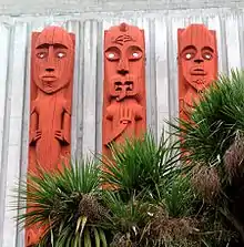 Guardian ancestors of Rangitāne | |
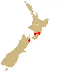 | |
| Rohe (region) | Manawatû, Wairarapa, Horowhenua and Tamakī-nui-a-rua |
| Waka (canoe) | Kurahaupo |
| Website | www |
Rangitāne in Manawatū
- Six hapū are based share Te Hotu Manawa marae and Tūturu Pumau wharenui in Palmerston North – Ngāti Hineaute, Ngāti Kapuārangi, Ngāti Rangiaranaki, Ngāti Rangitepaia and Ngāti Tauira & Ngāti Mairehau.
- A seventh hapū, Ngāti Mairehau, has the Motuiti mare and Rakau or Paewai wharenui in Himatangi.
Rangitāne o Wairau
Rangitāne o Wairau has a rohe over Marlborough, including much of Kahurangi National Park, Nelson Lakes National Park, Mount Richmond National Park and the Marlborough Sounds. Its marae (Tua Mātene) and wharenui (Te Huataki) are in Grovetown, just north of Blenheim. However, its rohe also includes the city of Nelson, and the towns of Takaka, Motueka, Saint Arnaud and Picton.[2]
Te Runanga a Rangitāne o Wairau Trust represents the iwi under the Māori Fisheries Act and Māori Commercial Aquaculture Claims Settlement Act 2004. It is run by an executive committee of ten trustees and a chairperson. Iwi Aquaculture Organisation in the Māori Commercial Aquaculture Claims Settlement Act 2004. Rangitāne o Wairau Settlement Trust governs the iwi's Treaty of Waitangi settlement under the Ngāti Apa ki te Rā Tō, Ngāti Kuia, and Rangitāne o Wairau Claims Settlement Act, and represents the iwi in resource consent consultation under the Resource Management Act 1991. Both trusts share managers and offices in Blenheim.[2]
The iwi has interests in the territory of Tasman District Council, Nelson City Council and Marlborough District Council. It also has a working relationship with Kaikoura District Council and Buller District Council on issues relating to waterways, catchment areas and coastal areas.[2]
Rangitāne o Tamaki-nui-a-rua
Rangitāne rohe on the eastern side of the Ruahine/Tararua Ranges stretches from Rakautatahi through to Eketahuna. This rohe is centered on the town of Dannevirke, where there are three Rangitāne Marae, Mākirikiri, Kaitoki, and Whiti-te-rā.
Demographics
Rangitāne (Hawke’s Bay/Wairarapa)
- 1991 census: 156
- 2001 census: 1,197
- 2006 census: 1,566
- 2013 census: 2,217
Major regional locations
- Wellington: 822
- Manawatū–Wanganui: 543
- Hawke's Bay: 288[3]
Rangitāne (Manawatū)
- 1991 census: 330
- 2001 census: 822
- 2006 census: 1,281
- 2013 census: 1,488
Major regional locations
- Manawatū–Wanganui: 744
- Wellington: 201[3]
Rangitāne (unspecified)
- 1991 census: 3,003
- 2001 census: 1,689
- 2006 census: 1,569
- 2013 census: 94[3]
Media
Kia Ora FM is the official radio station of the Rangitāne people. It began as Radio Rangitane, or Te Reo Irirangi O Rangitane, on 1 May 1992, and adopted its current name in the 2000s. It broadcasts from Palmerston North and is available on 89.8 FM in Manawatu.[4][5]
See also
References
- Rangitāne Archived 2008-10-06 at the Wayback Machine in Te Ara – the Encyclopedia of New Zealand
- "Rangitāne o Wairau". tkm.govt.nz. Te Puni Kōkiri, New Zealand Government. Retrieved 16 March 2018.
- "4. – Rangitāne: Facts and figures". Te Ara: The Encyclopedia of New Zealand. Ministry for Culture and Heritage. Retrieved 6 March 2017.
- "Iwi Radio Coverage" (PDF). maorimedia.co.nz. Māori Media Network. 2007. Retrieved 14 June 2015.
- "Palmerston North". Welcome to the Radio Vault. New Zealand: The Radio Vault. 25 April 2009. Archived from the original on 4 May 2009. Retrieved 12 June 2015.
Further reading
- McEwen, J. M. Rangitane: a tribal history. Auckland: Heinemann Reed, 1990.