Rangitoto, Waikato
Rangitoto is a rural community in the Waitomo District and Waikato region of New Zealand's North Island.[1]
Rangitoto | |
|---|---|
Rural community | |
| |
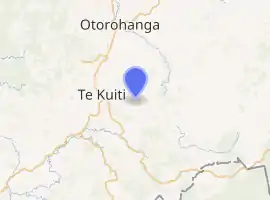
| Coordinates: 38.345956°S 175.256417°E | |
| Country | New Zealand |
| Region | Waikato |
| Territorial authority | Waitomo District |
| Population (2018) | |
| • Total | 168 |
| Postcode(s) | 3982 |
Demographics
Rangitoto is in meshblocks 1020500 and 1020600, which had a population of 168 in the 2018 census.[2] It is within the much larger Waipa Valley statistical area.
Marae
The area includes Te Ahoroa Marae, a Maniapoto tribal meeting ground of the Maniapoto hapū of Pare and Rereahu and the Rereahu hapū of Ngāti Paretapoko.[3] It includes the Tapairu meeting house.[4]
In October 2020, the Government committed $499,848 from the Provincial Growth Fund to upgrade the marae, creating an estimated 10 jobs.[5]
Education
Rangitoto School is a co-educational state primary school,[6] with a roll of 20 as of March 2020.[7][8] The school opened in 1920.[9]
References
- Hariss, Gavin. "Rangitoto, Waikato". topomap.co.nz. NZ Topo Map.
- "Meshblock Electoral Populations 2020 for proposed boundaries data". Statistics New Zealand. April 2020. Meshblocks 1020500 and 1020600.
- "Māori Maps". maorimaps.com. Te Potiki National Trust.
- "Te Kāhui Māngai directory". tkm.govt.nz. Te Puni Kōkiri.
- "Marae Announcements" (Excel). growregions.govt.nz. Provincial Growth Fund. 9 October 2020.
- "Rangitoto School Ministry of Education School Profile". educationcounts.govt.nz. Ministry of Education.
- "New Zealand Schools Directory". New Zealand Ministry of Education. Retrieved 26 April 2020.
- "Rangitoto School Education Review Office Report". ero.govt.nz. Education Review Office.
- "Welcome to Rangitoto School!". Rangitoto School. Retrieved 15 November 2020.
This article is issued from Wikipedia. The text is licensed under Creative Commons - Attribution - Sharealike. Additional terms may apply for the media files.