Marokopa
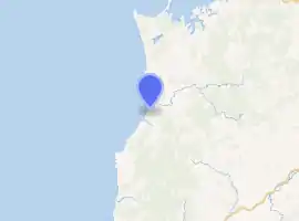
Marokopa is a rural community in Waitomo District and Waikato region of New Zealand. It is located close to the coast between Awakino and Kawhia Harbour. The meshblock includes the coastal township of Marokopa, at the mouth of the Marokopa River, and the south side of the small village of Awamarino, about 10 km (6.2 mi) upstream.[1]
Marokopa | |
|---|---|
Village | |
| |
| Coordinates: 38.305°S 174.721°E | |
| Region | Waikato region |
| Territorial authority | Waitomo District |
| Ward | Rural |
| Electorate | Taranaki-King Country |
| Population (2018 census) | |
| • Territorial | 69 |
| Time zone | UTC+12 (NZST) |
| • Summer (DST) | UTC+13 (NZDT) |
The area was settled by forestry workers in the 19th century. It has been predominantly a farming locale since the early 20th century. In 1911 a large dairy factory was built,[2] which mainly made butter which was shipped to Auckland. The Awamarino factory was enlarged in 1932,[3] but closed in 1937.[4] A telephone link to Te Kuiti was completed in 1914[5] and a service car[6] ran on Tuesdays and Fridays from 1920.[7] The town also had a post office,[8] a flaxmill[9] and a school (1908[10]-1982).[11] The nearest school is now Piripiri,[12] 20 km (12 mi) upstream.[13] There is a campground.[14]
Demographics
In 2018, Marokopa was in meshblocks 4002699-700. Previously, it was in meshblock 1019000. These meshblocks had these census results -[1][15]
| Year | Population | Households | Median age | Median income | National median |
|---|---|---|---|---|---|
| 2001 | 81 | 33 | 40.2 | $12,900 | $18,500 |
| 2006 | 84 | 42 | 46 | $19,200 | $24,100 |
| 2013 | 72 | 36 | 51.7 | $22,500 | $27,900 |
| 2018 | 69 |
Geology
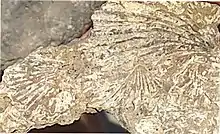
The coast between Marokopa and Kiritehere is accessible at low tide.[16] Along the few kilometres,[17] a succession of Late Triassic and Jurassic rocks are exposed. They are part of the western limb of the Kawhia Syncline, which extends north to the Hakarimatas[18] and have been described as the best Triassic sequence in the North Island.[19] The rocks are youngest at Marokopa (Aratauran) and oldest to the south of Kiritehere (Otapirian), where there is a large bed of monotis, one of the index fossils.[20]
Marae
Marokopa Marae and Miromiro i te Pō meeting house are a meeting ground for the local Maniapoto hapū of Kinohaku, Te Kanawa and Peehi.[21][22]
References
- "2013 Census map – QuickStats about a place". archive.stats.govt.nz. Retrieved 10 March 2019.
- "Marokopa Opening of Dairy Factory King Country Chronicle". paperspast.natlib.govt.nz. 2 September 1911. Retrieved 10 March 2019.
- "New Zealand Herald, Higher Dairy Output – The Marokopa Factory". paperspast.natlib.govt.nz. 19 November 1932. Retrieved 10 March 2019.
- "Butter Recovers New Zealand Herald". paperspast.natlib.govt.nz. 10 July 1937. Retrieved 10 March 2019.
- "King Country Chronicle, TELEPHONE EXTENSION. Marokopa linked up". paperspast.natlib.govt.nz. 1 April 1914. Retrieved 10 March 2019.
- "King Country Roads. Auckland Star". paperspast.natlib.govt.nz. 3 January 1925. Retrieved 10 March 2019.
- "Te Kuiti Mail Notices. King Country Chronicle". paperspast.natlib.govt.nz. 13 January 1920. Retrieved 10 March 2019.
- "New Zealand Herald, Kawhia". paperspast.natlib.govt.nz. 1 August 1907. Retrieved 10 March 2019.
- "New Zealand Herald, Country News". paperspast.natlib.govt.nz. 26 March 1908. Retrieved 10 March 2019.
- "New Zealand Herald, NEWS FROM COUNTRY DISTRICTS". paperspast.natlib.govt.nz. 18 May 1907. Retrieved 10 March 2019.
- Marsh, Dawn. "Schools in the Waitomo District". ketekingcountry.peoplesnetworknz.info. Retrieved 10 March 2019.
- "Piripiri School – 20/10/2016". Education Review Office. Retrieved 10 March 2019.
- "Marokopa to Piripiri School". Google maps. Retrieved 10 March 2019.
- "Marokopa Holiday Park | Waitomo District Council". www.waitomo.govt.nz. Retrieved 10 March 2019.
- "Meshblock Electoral Populations 2020 for proposed boundaries data". Statistics New Zealand. April 2020. Meshblocks 4002699-700.
- "Back-Block Roads. King Country Chronicle". paperspast.natlib.govt.nz. 4 October 1907. Retrieved 11 March 2019.
- "Kiritehere Beach, Waikato". NZ Topo Map. Retrieved 11 March 2019.
- MacFarlan, D. A. B. (1998). "Mesozoic stratigraphy of the Marokopa area". doi:10.1080/00288306.1998.9514812. Cite journal requires
|journal=(help) - Boffa Miskell (March 2016). "Natural Character Study of the Waikato Coastal Environment" (PDF).
- Campbell HJ, Raine JI, MacFarlan DA, Hudson N (2018). "Jurassic sequences of the North Island. Field Trip Guides. Geoscience Society of New Zealand Miscellaneous Publication 151B" (PDF). p. 34.
- "Te Kāhui Māngai directory". tkm.govt.nz. Te Puni Kōkiri.
- "Māori Maps". maorimaps.com. Te Potiki National Trust.
