River Barle
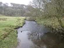
The River Barle runs from the Chains on northern Exmoor, in Somerset, England to join the River Exe at Exebridge, Devon. The river and the Barle Valley are both designated as biological Site of Special Scientific Interest.
| River Barle | |
|---|---|
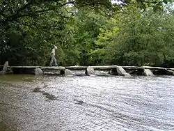 Tarr Steps viewed downstream | |
| Location | |
| Country | England |
| Counties | Devon, Somerset |
| Cities | Withypool, Simonsbath |
| Physical characteristics | |
| Source | |
| • location | Near Simonsbath, Exmoor, Somerset |
| • coordinates | 51°08′30″N 3°48′38″W |
| • elevation | 400 m (1,300 ft) |
| Mouth | River Exe |
• location | Exebridge, Devon |
• coordinates | 51°00′37″N 3°31′55″W |
| Length | 39.6[1] km (24.6 mi) |
| Basin features | |
| Tributaries | |
| • left | Little River |
| • right | Sherdon Water |
On the Chains above Simonsbath is a 3-acre (1.2-hectare) reservoir known as Pinkery Pond. It was formed in the 19th century when John Knight and his son dammed the river at that point. The pond's purpose is unknown, but vestiges of a small canal can be seen nearby.[2] Wheal Eliza Mine was an unsuccessful copper and iron mine on the river near Simonsbath.
The river passes under a late medieval six-arch stone Landacre Bridge in Withypool,[3] and the Tarr Steps a prehistoric clapper bridge possibly dating from 1000 BC. The stone slabs weigh up to 5 tons apiece. According to local legend, they were placed by the devil to win a bet. The bridge is 180 feet (55 m) long and has 17 spans.[4] It has been designated by English Heritage as a grade I listed building.[5] In Dulverton the river is crossed by the Barle Bridge.
Ecology
The river flows through the Somerset Wildlife Trust's Mounsey Wood Nature Reserve and Knaplock and North Barton SSSI, first notified in 1954, which are within Exmoor National Park. These sites are home to species such as the kingfisher and Knaplock and North Barton is one of the only sites of great burnet on Exmoor. The river itself has been recorded as a habitat for the Eurasian otter.[6]
Recreation
Walking
For much of its route, the river's banks are the path of the Two Moors Way footpath.[8]

References
- Lower Barle Middle Barle Upper Barle - Catchment Data Explorer
- Warren, Derrick (2005). Curious Somerset. Stroud: Sutton Publishing. pp. 107–108. ISBN 978-0-7509-4057-3.
- Historic England. "Landacre Bridge (1058006)". National Heritage List for England. Retrieved 2008-10-18.
- Leete-Hodge, Lornie (1985). Curiosities of Somerset. Bodmin: Bossiney Books. pp. 63–64. ISBN 0-906456-98-3.
- Historic England. "Tarr Steps (1247822)". National Heritage List for England. Retrieved 2007-05-09.
- "Barle Valley" (PDF). Natural England. Retrieved 2018-06-28.
- "River Barle". Everything Exmoor. Retrieved 2008-10-18.
- "Walk 1860 - The River Barle and Withypool from Tarr Steps". Walking Britain. Retrieved 2008-10-18.
- "Guide to the River Barle". UK Rivers Guidebook. Retrieved 2010-10-05.
- "River Barle". British Canoe Union South West. Archived from the original on 2008-10-24. Retrieved 2008-10-18.