Rockaway Beach, Oregon
Rockaway Beach is a city in Tillamook County, Oregon, United States. The population was 1,312 at the 2010 census.
Rockaway Beach, Oregon | |
|---|---|
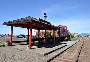 Visitor information center | |
 Location in Oregon | |
| Coordinates: 45°36′48″N 123°56′34″W | |
| Country | United States |
| State | Oregon |
| County | Tillamook |
| Incorporated | 1943 |
| Government | |
| • Mayor | Joanne Aagaard |
| Area | |
| • Total | 1.71 sq mi (4.42 km2) |
| • Land | 1.60 sq mi (4.14 km2) |
| • Water | 0.11 sq mi (0.28 km2) |
| Elevation | 17 ft (5 m) |
| Population | |
| • Total | 1,312 |
| • Estimate (2019)[3] | 1,416 |
| • Density | 885.00/sq mi (341.79/km2) |
| Time zone | UTC-8 (Pacific) |
| • Summer (DST) | UTC-7 (Pacific) |
| ZIP code | 97136 |
| Area code(s) | 503 and 971 |
| FIPS code | 41-62900[2] |
| GNIS feature ID | 1166705[4] |
| Website | www.rockawaybeachor.us |
History
The community of Rockaway was established as a seaside resort in 1909 by the Rockaway Beach Company.[5] It was named after Rockaway Beach on Queens, New York.[5] Rockaway post office was established in 1911.[5] Rockaway was connected by train to Portland in 1912.[6] The name of the city was changed to Rockaway Beach in 1987.[5]
The Pronto Pup, a brand of corn dog, was invented at Rockaway in the late 1930s.[7]
Geography
According to the United States Census Bureau, the city has a total area of 1.71 square miles (4.43 km2), of which, 1.60 square miles (4.14 km2) is land and 0.11 square miles (0.28 km2) is water.[8]
Demographics
| Historical population | |||
|---|---|---|---|
| Census | Pop. | %± | |
| 1930 | 300 | — | |
| 1950 | 1,027 | — | |
| 1960 | 771 | −24.9% | |
| 1970 | 665 | −13.7% | |
| 1980 | 906 | 36.2% | |
| 1990 | 970 | 7.1% | |
| 2000 | 1,267 | 30.6% | |
| 2010 | 1,312 | 3.6% | |
| 2019 (est.) | 1,416 | [3] | 7.9% |
| 1930 population[9] U.S. Decennial Census[10] | |||
2010 census
As of the census of 2010, there were 1,312 people, 667 households, and 374 families living in the city. The population density was 820.0 inhabitants per square mile (316.6/km2). There were 1,875 housing units at an average density of 1,171.9 per square mile (452.5/km2). The racial makeup of the city was 94.4% White, 0.4% African American, 0.7% Native American, 0.7% Asian, 1.1% from other races, and 2.7% from two or more races. Hispanic or Latino of any race were 2.9% of the population.[2]
There were 667 households, of which 16.8% had children under the age of 18 living with them, 44.8% were married couples living together, 8.1% had a female householder with no husband present, 3.1% had a male householder with no wife present, and 43.9% were non-families. 35.8% of all households were made up of individuals, and 16% had someone living alone who was 65 years of age or older. The average household size was 1.97 and the average family size was 2.52.[2]
The median age in the city was 55.1 years. 13.3% of residents were under the age of 18; 4.4% were between the ages of 18 and 24; 16% were from 25 to 44; 37.4% were from 45 to 64; and 29% were 65 years of age or older. The gender makeup of the city was 48.8% male and 51.2% female.[2]
2000 census
As of the census of 2000, there were 1,267 people, 635 households, and 368 families living in the city. The population density was 821.0 people per square mile (317.7/km2). There were 1,573 housing units at an average density of 1,019.3 per square mile (394.4/km2). The racial makeup of the city was 95.82% White, 0.08% African American, 1.10% Native American, 0.63% Asian, 0.71% from other races, and 1.66% from two or more races. Hispanic or Latino of any race were 1.97% of the population.[2]
There were 635 households, out of which 12.8% had children under the age of 18 living with them, 47.6% were married couples living together, 7.4% had a female householder with no husband present, and 41.9% were non-families. 35.3% of all households were made up of individuals, and 16.7% had someone living alone who was 65 years of age or older. The average household size was 1.99 and the average family size was 2.51.[2]
In the city, the population was spread out, with 14.0% under the age of 18, 3.9% from 18 to 24, 20.1% from 25 to 44, 31.3% from 45 to 64, and 30.6% who were 65 years of age or older. The median age was 52 years. For every 100 females, there were 96.7 males. For every 100 females age 18 and over, there were 94.8 males.[2]
The median income for a household in the city was $28,798, and the median income for a family was $35,742. Males had a median income of $30,956 versus $21,776 for females. The per capita income for the city was $17,766. About 7.0% of families and 10.8% of the population were below the poverty line, including 13.7% of those under age 18 and 5.9% of those age 65 or over.[2]
References
- "2019 U.S. Gazetteer Files". United States Census Bureau. Retrieved July 28, 2020.
- "U.S. Census website". United States Census Bureau. Retrieved 2012-12-21.
- "Population and Housing Unit Estimates". United States Census Bureau. May 24, 2020. Retrieved May 27, 2020.
- "US Board on Geographic Names". United States Geological Survey. 2007-10-25. Retrieved 2008-01-31.
- McArthur, Lewis A.; McArthur, Lewis L. (2003) [1928]. Oregon Geographic Names (7th ed.). Portland, Oregon: Oregon Historical Society Press. ISBN 978-0875952772.
- "Community Profiles - Rockaway Beach, Oregon" (PDF). Northwest Fisheries Science Center - NOAA. Retrieved 2007-06-10.
- "History of Pronto Pups". Pronto Pup Co., Inc. Archived from the original on 2007-02-23. Retrieved 2007-06-10.
- "US Gazetteer files 2010". United States Census Bureau. Archived from the original on 2012-01-25. Retrieved 2012-12-21.
- "Oregon Secretary of State: Seaside to Bay City". Oregon. 1940. Retrieved 28 October 2018.
- "Census of Population and Housing". Census.gov. Retrieved June 4, 2015.
External links
 Media related to Rockaway Beach, Oregon at Wikimedia Commons
- City of Rockaway Beach (official website)
- Entry for Rockaway Beach in the Oregon Blue Book
- Rockaway Beach Chamber of Commerce
- Rockaway Beach Official Tourism Website
Municipalities and communities of Tillamook County, Oregon, United States | ||
|---|---|---|
| Cities | 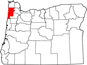 Tillamook County map | |
| CDPs | ||
| Unincorporated communities | ||
| ||