Saint-Cyr-le-Gravelais
Saint-Cyr-le-Gravelais is a commune in the Mayenne department in north-western France.
Saint-Cyr-le-Gravelais | |
|---|---|
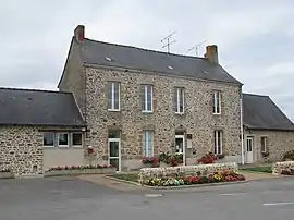 The town hall in Saint-Cyr-le-Gravelais | |
Location of Saint-Cyr-le-Gravelais 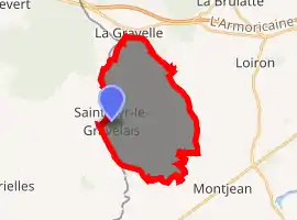
| |
 Saint-Cyr-le-Gravelais  Saint-Cyr-le-Gravelais | |
| Coordinates: 48°02′09″N 1°01′34″W | |
| Country | France |
| Region | Pays de la Loire |
| Department | Mayenne |
| Arrondissement | Laval |
| Canton | Loiron-Ruillé |
| Intercommunality | Laval Agglomération |
| Government | |
| • Mayor (2014–2020) | Simone Thireau |
| Area 1 | 19.82 km2 (7.65 sq mi) |
| Population (2017-01-01)[1] | 544 |
| • Density | 27/km2 (71/sq mi) |
| Time zone | UTC+01:00 (CET) |
| • Summer (DST) | UTC+02:00 (CEST) |
| INSEE/Postal code | 53209 /53320 |
| Elevation | 82–177 m (269–581 ft) (avg. 143 m or 469 ft) |
| 1 French Land Register data, which excludes lakes, ponds, glaciers > 1 km2 (0.386 sq mi or 247 acres) and river estuaries. | |
Geography
The river Oudon forms part of the commune's northern border.
See also
References
- "Populations légales 2017". INSEE. Retrieved 6 January 2020.
| Wikimedia Commons has media related to Saint-Cyr-le-Gravelais. |
| Authority control |
|---|
This article is issued from Wikipedia. The text is licensed under Creative Commons - Attribution - Sharealike. Additional terms may apply for the media files.