Saint-Georges-sur-Erve
Saint-Georges-sur-Erve is a commune in the Mayenne department, Pays de la Loire région in north-western France. The local people are known as 'Ervigeorgeais'.[2]
Saint-Georges-sur-Erve | |
|---|---|
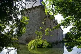 The Château de Foulletorte | |
Location of Saint-Georges-sur-Erve 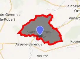
| |
 Saint-Georges-sur-Erve  Saint-Georges-sur-Erve | |
| Coordinates: 48°10′09″N 0°17′48″W | |
| Country | France |
| Region | Pays de la Loire |
| Department | Mayenne |
| Arrondissement | Mayenne |
| Canton | Évron |
| Intercommunality | Pays d'Évron |
| Government | |
| • Mayor (2020–2026) | Philippe Duytsche |
| Area 1 | 20.17 km2 (7.79 sq mi) |
| Population (2017-01-01)[1] | 385 |
| • Density | 19/km2 (49/sq mi) |
| Time zone | UTC+01:00 (CET) |
| • Summer (DST) | UTC+02:00 (CEST) |
| INSEE/Postal code | 53221 /53600 |
| Elevation | 129–326 m (423–1,070 ft) (avg. 180 m or 590 ft) |
| 1 French Land Register data, which excludes lakes, ponds, glaciers > 1 km2 (0.386 sq mi or 247 acres) and river estuaries. | |
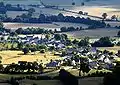
It consists of a small sized village, home to a school, library and town hall,[3] as well as a restaurant which serves as a tabac and newsagent to the village.
There is also a small mountain bike group, the Saint-Georges Adventure Group, which does yearly biking competitions starting at Saint-Georges to other areas.[4]
Gallery
 St Georges sur Erve
See also
References
- "Populations légales 2017". INSEE. Retrieved 6 January 2020.
- "CCPE: Les Communes: Saint Georges sur Erve" [CCPE: The Communes: Saint Georges sur Erve]. CCPE: Les Communes: Saint Georges sur Erve (in French). Archived from the original on 21 August 2014. Retrieved 21 August 2014.
- "Mairie de Saint-Georges-sur-Erve" [Saint-Georges-sur-Erve Town Hall]. Mairie de Saint-Georges-sur-Erve (in French). La Direction de l'information légale et administrative (Premier ministre). 2 October 2013.
- "Le sixième Raid VTT mayennais épaulé par des randonnées" [The Sixth Mayenne Raid VTT supported by hikers]. Ouest-France (in French). Retrieved 21 August 2014.
External links
| Wikimedia Commons has media related to Saint-Georges-sur-Erve. |
| Authority control |
|
|---|
This article is issued from Wikipedia. The text is licensed under Creative Commons - Attribution - Sharealike. Additional terms may apply for the media files.