Saint-Louis Parish, New Brunswick
Saint-Louis (originally Palmerston) is a civil parish in Kent County, New Brunswick, Canada.[2]
Saint-Louis
St. Louis | |
|---|---|
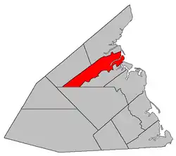 Location within Kent County, New Brunswick. | |
| Coordinates: 46.725°N 65.075°W | |
| Country | |
| Province | |
| County | Kent |
| Erected | 1855 |
| Area | |
| • Land | 258.74 km2 (99.90 sq mi) |
| Population (2016)[1] | |
| • Total | 1,802 |
| • Density | 7.0/km2 (18/sq mi) |
| • Change 2011-2016 | |
| • Dwellings | 785 |
| Time zone | UTC-4 (AST) |
| • Summer (DST) | UTC-3 (ADT) |
For governance purposes it is divided between the village of Saint-Louis de Kent and the local service districts of Saint-Ignace and the parish of Saint-Louis (which further contains the special service area of Canisto Road), all of which are members of the Kent Regional Service Commission (KRSC).[3]
Origin of name
The parish may take its name from the Roman Catholic ecclesiastical parish of Saint-Louis-des-Français.
History
Saint-Louis was erected as Palmerston Parish in 1855 from Carleton Parish.[4]
In 1857 the boundary with Carleton was altered to run along grant lines.[5]
In 1866 the parish was renamed Saint-Louis.[6]
In 1909 part of Saint-Louis was included in the new parish of Saint-Charles.[7]
Delineation
Saint-Louis Parish is defined in the Territorial Division Act[2] as being bounded:
- South by Weldford Parish and Saint-Charles Parish, east by Saint-Charles Parish and the Gulf of Saint Lawrence, and north by a line commencing on the shore of the Gulf of Saint Lawrence, where the eastern prolongation of the southern line of Lot C, granted to George Kollock, intersects the same; thence westerly along said prolongation and line to the southerly prolongation of the eastern line of the William Dwyer lot, being lot number 41; thence northerly along said last mentioned prolongation and eastern line of said lot number 41, to the rear line of lot number 10, granted to James Graham; thence along the rear lines of lots granted to the said James Graham and to John Murphy, Thomas Jardine, Patrick MacKay, Patrick Harrington, and Dennis Harrington, to the eastern line of lot number 24, granted to Lucas Christian; thence southerly along said eastern line of lot number 24 to a line, being the western prolongation of the southern line of lot C, granted to George Kollock; thence westerly along said last mentioned prolongation to the post road; thence along the post road northerly to the northeast boundary of a grant to Basil White; thence along the northerly line of Basil White's lot west to the old post road[lower-alpha 1]; thence along the old post road southerly to the northeast boundary of the grant to Peter Vautour; thence along the northerly side line of Peter Vautour's lot to the northwest angle thereof; and thence south seventy-five degrees and thirty minutes west to the southern line of the parish, including the islands in front.
Communities
|
|
Demographics
Population
|
LanguageMother tongue (2016)[1]
|
See also
Notes
References
- "Census Profile, 2016 Census Saint-Louis, Parish [Census subdivision], New Brunswick". Statistics Canada. Retrieved September 14, 2019.
- "Chapter T-3 Territorial Division Act". Government of New Brunswick. Retrieved 13 November 2020.
- "Communities in each of the 12 Regional Service Commissions (RSC) / Les communautés dans chacune des 12 Commissions de services régionaux (CSR)" (PDF), Government of New Brunswick, July 2017, retrieved 2 February 2021
- "18 Vic. c. 49 An Act to divide the Parish of Carleton, in the County of Kent, into two Parishes.". Acts of the General Assembly of Her Majesty's Province of New Brunswick, Passed in the Month of November, 1854, and in the Months of February, March, and April, 1855. Fredericton: Government of New Brunswick. 1855. p. 178.
- "20 Vic. c. 10 An Act to amend an Act to divide the Parish of Carleton, in the County of Kent, into two Parishes.". Acts of the General Assembly of Her Majesty's Province of New Brunswick, Passed in July 1856, and March and July 1857. Fredericton: Government of New Brunswick. 1857. p. 16.
- "29 Vic. c. 10 An Act to change the name of the Parish of Palmerston in the County of Kent.". Acts of the General Assembly of Her Majesty's Province of New Brunswick, Passed in the Months of March, April, and July, 1866. Fredericton: Government of New Brunswick. 1866. p. 23.
- "8 Edward 7 c. 21 An Act to amend the Act respecting the division of the Province into Counties, Towns and Parishes, so far as relates to the County of Kent.". Acts of the Legislative Assembly of New Brunswick Passed in the Month of May 1908. Fredericton: Government of New Brunswick. 1908. pp. 49–52.
- "No. 236" (PDF). 2015 Designated Highway Maps. Government of New Brunswick. Retrieved 25 August 2016.
- "Crown Grant Reference Map Viewer". GeoNB. Government of New Brunswick. Retrieved 25 August 2016.
- Statistics Canada: 1996, 2001, 2006 census
- 2011 Statistics Canada Census Profile: Saint-Louis Parish, New Brunswick
Places adjacent to Saint-Louis Parish, New Brunswick | ||||||||||
|---|---|---|---|---|---|---|---|---|---|---|
| ||||||||||
| Subdivisions | |
|---|---|
| Cities | |
| Counties | |
| |