Salmon Falls Dam
Salmon Falls Dam is a dam constructed across Salmon Falls Creek in Twin Falls County, Idaho, in the United States. Located about 28 miles (45 km) southwest of Twin Falls, the masonry arch-gravity dam is 217 feet (66 m) high and 450 feet (140 m) long, impounding up to 230,650 acre feet (0.28450 km3) of water in Salmon Falls Creek Reservoir.[1] When full, the reservoir extends for 17 miles (27 km) upstream, encompassing 3,400 acres (1,400 ha). The dam and reservoir control runoff from a drainage basin of 1,610 sq mi (4,200 km2).[1]
| Salmon Falls Dam | |
|---|---|
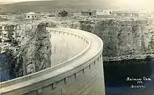
 Salmon Falls Dam shortly after completion in 1910 | |
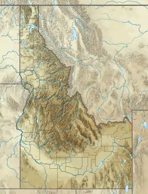
 Location in Idaho  Location in United States | |
| Country | United States |
| Location | Twin Falls County, Idaho |
| Coordinates | 42°12′43″N 114°44′04″W |
| Purpose | Irrigation |
| Opening date | 1910 |
| Owner(s) | Salmon River Canal Company |
| Dam and spillways | |
| Type of dam | Concrete gravity arch |
| Impounds | Salmon Falls Creek |
| Height | 217 ft (66 m)[1] |
| Length | 450 ft (140 m)[1] |
| Reservoir | |
| Creates | Salmon Falls Creek Reservoir |
| Total capacity | 230,650 acre⋅ft (284,500 dam3)[1] |
| Catchment area | 1,610 sq mi (4,200 km2)[1] |
| Surface area | 3,400 acres (1,400 ha)[1] |
| Maximum length | 14 mi (23 km) |
The dam was built in 1910 to provide irrigation water storage, and is owned and operated by the Salmon River Canal Company.[2] A secondary purpose is flood control: the dam has spilled floodwaters twice, in 1984 and 2017. Salmon Falls Creek Reservoir is also a popular recreational lake, and is considered one of the best fisheries in southern Idaho.[3]
The dam was the third-largest dam in the world at the time of its construction. It was part of a major reclamation effort which partly failed due less water being available than planned, partly due to unexpected leakage of water through the lava rock used in the dam's construction.[4]
The Milner Dam (1904) was more successful.[4]
The Salmon Falls Tract, the associated reclamation project, was originally termed the Salmon River Tract, and the dam was named the Salmon Dam. That naming "was chosen over Salmon Falls because the project promoters believed it had more appeal, although the dam’s name was changed back to Salmon Falls".[5]
Historic site
Salmon Falls Dam | |
| Nearest city | Rogerson, Idaho |
|---|---|
| Area | 10 acres (4.0 ha) |
| Built | 1908–1910 |
| Engineer | Andrew J. Wiley |
| Architectural style | Concrete Arch Dam |
| NRHP reference No. | 09000328[6] |
| Added to NRHP | May 15, 2009 |
The Salmon Falls Dam was listed on the National Register of Historic Places in 2009. The listing included a contributing building and six contributing structures in addition to the dam itself, on 10 acres (4.0 ha).[6] The dam's engineer was Andrew J. Wiley. The historic listing includes the dam, one building, and seven other structures.[7]
Gallery
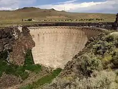
 Salmon Falls Creek Dam viewed from the west
 Salmon Falls Creek Dam viewed from the east
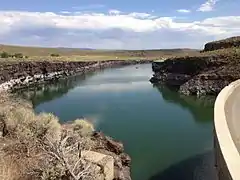
 View south up the Salmon Falls Creek Reservoir from the east end of the Salmon Falls Creek Dam
See also
References
- "Salmon Falls Dam". National Performance of Dams Program. Stanford University. Archived from the original on 2016-03-11. Retrieved 2012-08-18.
- "History". Salmon River Canal Company. Archived from the original on 2012-07-23. Retrieved 2012-08-18.
- "Salmon Falls Creek Reservoir". Burley Recreation. U.S Bureau of Land Management. 2011-07-22. Archived from the original on 2009-05-10. Retrieved 2012-08-18.
- Virginia Ricketts; Elizabeth Egleston (April 10, 1991). "National Register of Historic Places Registration: Hollister School / Hollister Elementary; 007973". National Park Service. Retrieved September 21, 2019. With accompanying two photos from 1991
- "Planning for Paradise: Idaho's Salmon Falls Dam" (PDF). Fall 2008.
- "National Register Information System". National Register of Historic Places. National Park Service. November 2, 2013.
- "National Register of Historic Places Inventory/Nomination: Salmon Falls Dam". National Park Service. Retrieved September 21, 2019.