Sandy Oaks, Texas
Sandy Oaks is a city in Bexar County, Texas, United States. The community voted to incorporate in an election held on May 14, 2014. A total of 128 votes were cast in the election, 96 (75%) in favor of incorporation and 32 (25%) against.[4]
Sandy Oaks, Texas | |
|---|---|
| City of Sandy Oaks | |
 Sandy Oaks  Sandy Oaks | |
| Coordinates: 29°10′53″N 98°24′27″W | |
| Country | United States |
| State | Texas |
| County | Bexar |
| Incorporated | May 14, 2014 |
| Government | |
| • Type | Type A General-Law Municipality |
| Area | |
| • Total | 2.38 sq mi (6.18 km2) |
| • Land | 2.38 sq mi (6.18 km2) |
| • Water | 0.00 sq mi (0.00 km2) |
| Elevation | 623 ft (190 m) |
| Population (2010) | |
| • Total | 4,488 |
| • Estimate (2019)[2] | 4,660 |
| • Density | 1,953.88/sq mi (754.36/km2) |
| Time zone | UTC-6 (Central (CST)) |
| • Summer (DST) | UTC-5 (CDT) |
| ZIP code | 78112 |
| Area code(s) | 210, 726 |
| FIPS code | 48-65344 [3] |
| GNIS feature ID | 2771705 |
| ANSI Code | 2771704[3] |
| Website | CityofSandyOaks.com |
Geography
Sandy Oaks is located along Interstate 37 at the intersection of Priest and Mathis roads in southeastern Bexar County. The city covers a total of 2.39 square miles.[5]
Education
The city of Sandy Oaks is served by the Southside Independent School District.
References
- "2019 U.S. Gazetteer Files". United States Census Bureau. Retrieved August 7, 2020.
- "Population and Housing Unit Estimates". United States Census Bureau. May 24, 2020. Retrieved May 27, 2020.
- "US Gazetteer Files 2016-Places-Texas". US Census. Retrieved 24 January 2017.
- Results of Election and Order of Incorporation - City of Sandy Oaks, Texas. Retrieved December 14, 2015.
- City Map - City of Sandy Oaks, Texas. Retrieved December 14, 2015.
- "Census of Population and Housing". Census.gov. Retrieved June 4, 2016.
External links
- City of Sandy Oaks - Official website.
- U.S. Geological Survey Geographic Names Information System: Sandy Oaks
Municipalities and communities of Bexar County, Texas, United States | ||
|---|---|---|
| Cities | 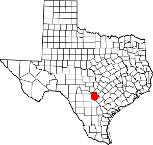 Bexar County map | |
| Towns | ||
| CDPs | ||
| Other unincorporated communities | ||
| Footnotes | ‡This populated place also has portions in an adjacent county or counties | |
| ||
This article is issued from Wikipedia. The text is licensed under Creative Commons - Attribution - Sharealike. Additional terms may apply for the media files.