Timberwood Park, Texas
Timberwood Park is a census-designated place (CDP) in Bexar County, Texas, United States. G.G. Gale was the developer from 1976 until completion around 2011. The subdivision has roughly 42 miles of roads and encompasses over 2,000 acres. The overall plan shows 3,263 platted lots. The population was 13,447 at the 2010 census,[4] up from 5,889 at the 2000 census. It is part of the San Antonio Metropolitan Statistical Area.
Timberwood Park, Texas | |
|---|---|
 | |
| Coordinates: 29°41′41″N 98°29′29″W | |
| Country | United States |
| State | Texas |
| County | Bexar |
| Area | |
| • Total | 21.07 sq mi (54.6 km2) |
| • Land | 21.02 sq mi (54.4 km2) |
| • Water | 0.05 sq mi (0.1 km2) |
| Elevation | 1,234 ft (376 m) |
| Population (2010) | |
| • Total | 13,447 |
| • Density | 640/sq mi (250/km2) |
| Time zone | UTC-6 (Central (CST)) |
| • Summer (DST) | UTC-5 (CDT) |
| Zip Code | 78260 |
| FIPS code | 48-73057[1] |
| GNIS feature ID | 1867569[2] |
| ANSI Code | 2409324[3] |
Geography
Timberwood Park is a neighborhood exclusive from other separate neighborhoods that butt up to Canyon Golf Road to its east, by Deer Cross Lane and Midnight Drive to its south, Borfgeld Road to its north, and Blanco Road up to Slumber Pass on the west, with the most northwesterly border of the neighborhood encompassing only so far west as Bubbling Brook Drive, Sunny Meadow Drive, Silent Hollow, Symphonic Hill, and Streisand Street. Timberwood Park is about 22 miles (35 km) north of downtown San Antonio.
According to the United States Census Bureau, the CDP has a total area of 21.07 square miles (54.6 km2), of which, 21.02 square miles (54.4 km2) of it is land and 0.05 square miles (0.13 km2) is water.[3]
Demographics
As of the census[1] of 2000, there were 5,889 people, 2,002 households, and 1,721 families residing in the CDP. The population density was 309.5 people per square mile (119.5/km2). There were 2,065 housing units at an average density of 108.5/sq mi (41.9/km2). The racial makeup of the CDP was 90.25% White, 1.10% African American, 0.46% Native American, 1.09% Asian, 4.33% from other races, and 2.77% from two or more races. Hispanic or Latino of any race were 20.26% of the population. The area submitted a petition signed by more than 4,100 residents to the City of San Antonio seeking immediate annexation - a ploy to get permission from the Texas Legislature to incorporate under Texas Statutory law.
There were 2,002 households, out of which 44.7% had children under the age of 18 living with them, 78.2% were married couples living together, 5.6% had a female householder with no husband present, and 14.0% were non-families. 11.4% of all households were made up of individuals, and 2.8% had someone living alone who was 65 years of age or older. The average household size was 2.94 and the average family size was 3.18.
In the CDP, the population was spread out, with 29.4% under the age of 18, 5.4% from 18 to 24, 31.5% from 25 to 44, 27.5% from 45 to 64, and 6.2% who were 65 years of age or older. The median age was 38 years. For every 100 females, there were 100.2 males. For every 100 females age 18 and over, there were 96.7 males.
The median income for a household in the CDP was $79,053, and the median income for a family was $83,203. Males had a median income of $52,196 versus $36,761 for females. The per capita income for the CDP was $34,385. About 1.8% of families and 3.4% of the population were below the poverty line, including 5.5% of those under age 18 and 5.6% of those age 65 or over.
Education
Timberwood Park is served by the Comal Independent School District, and North East Independent School District.[5]
The CISD portion is assigned to:
- Timberwood Park, Specht, and Kinder Ranch elementary schools[6]
- Most residents are in the Spring Branch Middle School zone, with some in the Smithson Valley Middle zone[7]
- Smithson Valley High School[8]
The NEISD portion is assigned to:
- Tuscany Heights Elementary School[9]
- Portions zoned to Bush Middle School and Tejeda Middle School[10]
- Portions zoned to Ronald Reagan High School and Lady Bird Johnson High School[11]
History of schools
Previously areas in Timberwood Park in NEISD had Oak Meadow Elementary as the overflow school.[12]
Roan Forest Elementary previously served sections of the NEISD portion.[13]
Reagan previously served all of the NEISD portion.[14] After Johnson opened, portions of Timberwood Park were reassigned to Johnson.[15]
References
- "U.S. Census website". United States Census Bureau. Retrieved 2008-01-31.
- "US Board on Geographic Names". United States Geological Survey. 2007-10-25. Retrieved 2008-01-31.
- "US Gazetteer Files 2016-Places-Texas". US Census. Retrieved 24 January 2017.
- "Geographic Identifiers: 2010 Demographic Profile Data (G001): Timberwood Park CDP, Texas". U.S. Census Bureau, American Factfinder. Archived from the original on February 12, 2020. Retrieved April 15, 2014.
- "2010 CENSUS - CENSUS BLOCK MAP: Timberwood Park CDP, TX" (Archive). U.S. Census Bureau. Retrieved on August 26, 2016.
- "Elementary School Attendance Zones" (Archive). Comal Independent School District. Retrieved on August 28, 2016. Timberwood Park zone (Archive), Specht zone (Archive), Kinder Ranch zone (Archive)
- "Middle School Attendance Zones" (Archive). Comal Independent School District. Retrieved on August 28, 2016. Spring Branch Middle zone (Archive); Smithson Valley Middle zone (Archive)
- "High School Attendance Zones" (Archive). Comal Independent School District. Retrieved on August 28, 2016. Smithson Valley HS zone (Archive)
- "Elementary School Boundaries 2015-2016." North East Independent School District. Retrieved on August 26, 2016.
- "Middle School Boundaries 2015-2016." North East Independent School District. Retrieved on August 26, 2016.
- "HS Boundaries 2015-2016." North East Independent School District. Retrieved on August 26, 2016.
- "Capping at Hardy Oak, Stone Oak and Encino Park elementary schools." North East Independent School District. August 6, 2001. Retrieved on August 27, 2016.
- "Roan Forest" (Archive) (2006-2007 Map). North East Independent School District. Retrieved on August 26, 2016.
- Reagan High School Map (Archive). North East Independent School District. February 6, 2006. Retrieved on August 26, 2016.
- "Johnson High School" (Archive). North East Independent School District. July 4, 2008. Retrieved on August 26, 2016.
Municipalities and communities of Bexar County, Texas, United States | ||
|---|---|---|
| Cities | 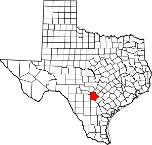 Bexar County map | |
| Towns | ||
| CDPs | ||
| Other unincorporated communities | ||
| Footnotes | ‡This populated place also has portions in an adjacent county or counties | |
| ||