Shaganappi Trail
Shaganappi Trail is a major super-4 expressway in the northwest quadrant of Calgary, Alberta. It extends to the south as Montgomery View, a small service road in the neighborhood of Montgomery and that provides access to Edworthy Park, passes north past Market Mall and the western boundary of Nose Hill Park, and terminates in the neighborhood of Nolan Hill in the north, with city planning maps indicating future northern extension beyond 144 Avenue NW.[2] The name "Shaganappi" is of Cree origin, referring to the bison hide lacings that held Red River ox carts together.[3] Despite the name, it is not located near the Shaganappi neighborhood, which is located south of the Bow River.
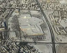 View of Shaganappi Trail's intersections with 32 Avenue NW and 40 Avenue NW, with Market Mall visible. | |
| Maintained by | City of Calgary |
|---|---|
| Length | 15.3 km[1] (9.5 mi) |
| Location | Calgary, Alberta |
| South end | 16 Avenue NW (Hwy 1) / Bowness Road |
| Major junctions | Crowchild Trail (Hwy 1A) John Laurie Boulevard Country Hills Boulevard Stoney Trail (Hwy 201) |
| North end | 144 Avenue NW |
| Neighborhoods |
|---|
Route
Shaganappi Trail begins as a short 2 lane road providing access to Edworthy Park. After crossing Bowness Road at a signal light it immidielty travels through a interchange with 16 Avenue before widening to a 4 lane cross section with a 70km/h speed limit. It then climbs up a hill below the Alberta Children's Hospital out of the river valley. At the top it passes through signal lights at Campus Way, 32nd Avenue, 40th Avenue and Varsity Drive passing next to Market Mall and through the community of Varsity. It then passes over Crowchild Trail in a spit diamond interchange before continuing past Northland Mall. The road widens to 5 lanes a passes through lights at Dalhousie Drive and John Laurie Boulevard and the speed limit rises to 80km/h. The road then cuts up a steep hill through Nose Hill park where deer are frequently seen. After passing a intersection for Edgemont it then descends down another steep hill past some lights at Country Hills Boulevard. After that the expressway ends and the road shrinks to 2 lanes and the speed limit goes down to 60km/h. It crosses Stoney Trail at a partial Cloverleaf interchange before widening to a 4 lane arterial road. From there it continues north until arriving at it's terminus with 144 Avenue.
History
Shaganappi Trail was originally planned in 1970 to be part of a network of freeways. The 1970 functional study planned it to extend south as a controlled access road from the future ring road (now Stoney Trail) past several Interchanges to a three-level interchange at Crowchild Trail. From there on it would continue through Varsity, past Interchanges connecting to Market Mall and then down the hill to connect to a massive six-way, free-flowing cloverstack interchange with a proposed Highway 1 freeway and Memorial Drive. (Now called Bowness Road). From there it would then cross the Bow River and connect with Bow Trail and Sarcee Trail at another major interchange.[4] Edworthy Park on both sides of the rivers was meant to be a temporary park to protect the right-of-way, since there are no Bow River crossings between 16 Avenue NW to the west and Crowchild Trail to the east. The 6-lane freeway was planned to be built in three stages, with the first stage being built soon after the functional plan was released. The first stage involved constructing Shaganappi as a 4 lane limited-access road with signalized intersections. It was constructed from Bowness Road to what is now Country Hills Boulevard. At the same time, the small overpass carrying 16 Ave was grandfathered into an interchange with Shaganappi from an older road arrangement. The plan to extend Shaganappi across the river and upgrade it to a freeway was proposed again in the 1995 Calgary Transportation Plan, also known as the "Go Plan"; however public opposition to both it and a similar plan to extend Sarcee Trail through a natural area, led to it officially being eliminated from the plans in 2009.[5][6] As a result the road remains mostly in its stage one configuration in the present time.
In the 1990s the road was extended into Hidden Valley and a split diamond interchange was constructed at Crowchild trail. The road was extended beyond the Stoney trail right of way when the Sherwood community was developed around 2005. In 2009 when northwest Stoney Trail opened, a Partial cloverleaf interchange with a 3-lane overpass was constructed to service Shagannapi. However, grading was put in place to allow it to be easily upgraded to a cloverstack interchange[7] if the freeway plans were implemented. Shaganppi was extended north as an Arterial road to 144 Ave in 2013 as more neighbourhoods were built. 144 ave is currently the edge of the city, but when future communities get built farther north, Shaganppi will likely be extended further.
Future
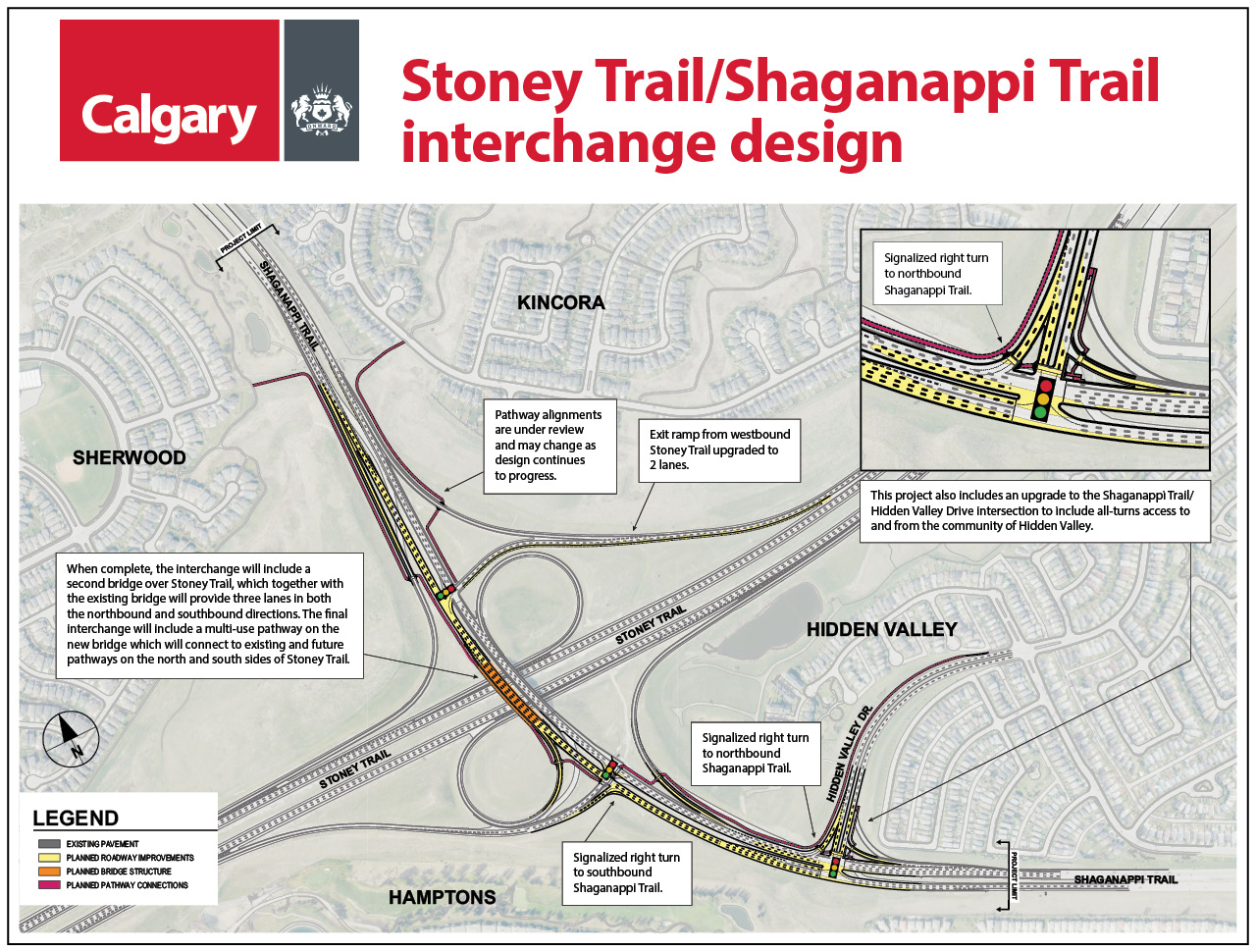
After the cancelation of the extension south of the Bow river and the 16 Avenue connecting freeway Shaganappi Trail was downgraded in classification to an arterial road south of Crowchild Trail. Recently made long term plans have moved away from freeway conversion and instead plan a 6 lane arterial street with curb HOV lanes, additional signalized intersections and bike lanes.[8] The confusing and accident-prone interchange complex at 16 Ave, Bowness road and Shaganappi Trail also is now planned to be replaced by a diamond Interchange favouring 16 Avenue resulting in 2 new signal lights along Shagannapi.[9] Between Crowchild and Stoney Trail, Shagannapi remains classified as a skeletal road by the City of Calgary and freeway upgrades still remains a possibility in the long term. That section of the corridor is also planned to contain a future BRT route as well which may run on the shoulder of the Shaganappi trail or on its own parallel road. constructed as limited-access road to allow for upgrades to freeway up to Stoney Trail with grading in place to allow for it to be upgraded to a cloverstack interchange;[7] [10] Starting in 2021 the overpass at Stoney trail is going to be twined to allow for 6 lanes to cross Stoney rather than the current 3. As part of the project a full access signalized intersection is planned at Hidden Valley Drive.[11]
Major intersections
From south to north.[2] The entire route is in Calgary.
{{ABint
| km[1] | mi | Destinations | Notes | ||
|---|---|---|---|---|---|
| 0.0– 0.3 | 0.0– 0.19 | Montgomery View | Partially grade-separated; access to Foothills Medical Centre and Edworthy Park | ||
| 1.4 | 0.87 | Access to Alberta Children's Hospital | |||
| 3.1 | 1.9 | 32 Avenue NW | Access to Market Mall and University of Calgary | ||
| 2.9 | 1.8 | 40 Avenue NW | Access to Market Mall | ||
| 3.5 | 2.2 | Varsity Drive | |||
| 4.1– 4.2 | 2.5– 2.6 | Split diamond interchange | |||
| 4.5 | 2.8 | 52 Avenue NW | Northbound right-in/right-out; access to Northland Village Mall | ||
| 4.9 | 3.0 | Northland Drive / Dalhousie Drive | Access to Northland Village Mall | ||
| 5.6 | 3.5 | John Laurie Boulevard | |||
| 7.7 | 4.8 | Edgemont Boulevard | Access to Nose Hill Park | ||
| 9.8 | 6.1 | Country Hills Boulevard | |||
| 10.9 | 6.8 | Hidden Valley Drive | Partial seagull intersection; northbound exit, southbound entrance | ||
| 11.0– 12.0 | 6.8– 7.5 | Partial cloverleaf interchange; exit 48 on Hwy 201 | |||
| 13.5 | 8.4 | Symons Valley Parkway | |||
| 13.8 | 8.6 | Sage Hill Boulevard | |||
| 14.1 | 8.8 | Nolan Hill Boulevard | |||
| 14.4 | 8.9 | Sage Valley Boulevard | |||
| 15.3 | 9.5 | 144 Avenue NW | |||
| 1.000 mi = 1.609 km; 1.000 km = 0.621 mi | |||||
Pedestrian crossings
Because of the roadway's width, high traffic volume, and the need for pedestrians to cross it, three dedicated crossings have been built, one at Market Mall, one near Valiant Drive, and one at Northland Village Mall called the Shaganappi Trail Pedestrian Overpass (2015).[12]
See also
References
- Google (December 16, 2016). "Shaganappi Trail in Calgary, AB" (Map). Google Maps. Google. Retrieved December 16, 2016.
- Sherlock's Map of Calgary (16th ed.). Langdon, Alberta: Sherlock Publishing Ltd. 2014. pp. 3, 4, 9, 10, 17 and 25. ISBN 1-895229-80-4.
- "shaganappi". Dictionary.com. Retrieved December 16, 2016.
- Engineering Department (January 1970). Shaganappi Trail Functional Planning Report - Sarcee Trail NW to Bow Trail SW (PDF) (Report). City of Calgary. Archived from the original (PDF) on October 10, 2017. Retrieved April 5, 2018.
- 1995 Calgary Transportation Plan (Go Plan) (Report). City of Calgary. February 19, 1994.
- "Crossing the Elbow River – 1990 to 1995". Calgary Ring Road. January 6, 2015. Retrieved April 5, 2018.
- "Stoney Trail Ultimate Configuration Plan - Country Hills Boulevard to Panorama Hills Boulevard" (PDF). Alberta Transportation. July 4, 2003. Retrieved April 5, 2018.
- "Shaganappi Trail North Corridor and HOV Study". Transportation Planning. City of Calgary. July 24, 2012. Retrieved April 5, 2018.
- "South Shaganppi Study Report" (PDF). Transportation Planning. Retrieved 16 Jan 2021.
- Calgary Transportation Plan (PDF). Transportation Planning (Report). City of Calgary. September 2009. Retrieved April 4, 2018.
- "North Stoney Interchange Project/Shaganappi trail". Construction Projects. Retrieved 17 January 2021.
- "Shaganappi Trail Pedestrian Overpass". Hatch Infrastructure Projects. Hatch Engineering. Retrieved 3 December 2019.