Alberta Highway 1
Alberta Provincial Highway No. 1, commonly referred to as Highway 1, is a major east–west highway in Southern Alberta that forms the southern mainline of the Trans-Canada Highway. It runs from the British Columbia border near Lake Louise through Calgary to the Saskatchewan border east of Medicine Hat. It continues as Highway 1 into both provinces. It spans approximately 534 km (332 mi) from Alberta's border with British Columbia in the west to its border with Saskatchewan in the east.[3] The route is a divided 4 lane expressway throughout the province with the exception of a section in central Calgary where it is an arterial thoroughfare and Urban Boulevard carrying 4 to 6 lanes. The highway is a freeway between the Sunshine exit near the town of Banff and Home Road in Calgary. Other rural sections have at grade intersections with Interchanges only at busier junctions. Twinning of the final 8.5 km (5.3 mi) of Highway 1 between Lake Louise and the British Columbia border was completed by Parks Canada and opened to traffic on June 12, 2014 making the whole length of Alberta Highway 1 a divided minimum 4 lane route.[3]
| ||||
|---|---|---|---|---|
| Trans-Canada Highway | ||||
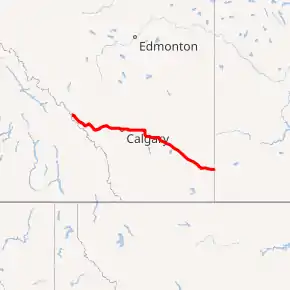
Highway 1 highlighted in red | ||||
| Route information | ||||
| Length | 533.8 km[1] (331.7 mi) | |||
| Existed | 1941[2]–present | |||
| Major junctions | ||||
| West end | ||||
| East end | ||||
| Location | ||||
| Specialized and rural municipalities | I.D. No. 9, Bighorn No. 8 M.D., Kananaskis I.D., Rocky View County, Wheatland County, Newell County, Cypress County | |||
| Major cities | Calgary, Brooks, Chestermere, Medicine Hat | |||
| Towns | Banff, Canmore, Strathmore, Bassano, Redcliff | |||
| Highway system | ||||
Provincial highways in Alberta
| ||||

Route description
Highway 1 is designated as a core route in Canada's National Highway System[4] and is a core part of the developing Alberta Freeway Network.
British Columbia border to Calgary
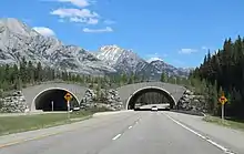
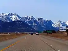
British Columbia Highway 1 becomes Alberta Highway 1 as it crosses Kicking Horse Pass into Alberta.[3] It generally travels in a southeast direction along the wide and scenic Bow River valley through Banff National Park (Improvement District No. 9) crossing the Bow river 3 times. After a scenic descent from the pass with great views of Mount Temple it crosses the Bow River. Its first junction is an interchange with Highway 93 north (the Icefields Parkway), which runs concurrent with Highway 1 for the next 25km. Shortly after that Highway 1/93 crosses the Pipestone River passes through a single Interchange servicing the Hamlet of Lake Louise, the Lake Louise Ski Resort and access to Lake Louise itself as well as Moraine Lake. From there the highway crosses the Bow River and travels along the west bank of the river passing by several trail heads until reaching the Interchange for Highway 93 south (Banff-Radium Highway) which contributes a significant amount of eastbound traffic and is also a mid point access to the Bow valley Parkway. From there the highway continues past several more trailheads turn offs (all at grade) with great views of the Sawback range from the highway. After passing a Interchange for the Banff Sunshine Ski Area the highway bends to the west and approaches the town of Banff. The Highway climbs up from the river and scales the side of a cliff above the town. A pullout at the top of the small climb allows visitors to overlook Town of Banff,[5]Vermilion Lakes and Mount Rundle. The highway then passes 2 Interchanges servicing Banff and surrounding attractions. From there the highway bends to the south and leaves the park. The entire segment of Highway 1 through the national park is maintained by the Government of Canada,[6] all sections of Banff Park Highway have wildlife fences and overpasses to keep animals off the road. The speed limit on most park sections is 90km/h.
Upon exiting Banff National Park, Highway 1 is maintained by Alberta Transportation for 91 km (57 mi) until it reaches Calgary.[5][7] This segment of the highway generally travels in an east direction through the rural municipalities of the Municipal District of Bighorn No. 8 and Rocky View County, It also briefly crosses a portion of Kananaskis Improvement District.[8] Shortly after leaving Banff Park the highway passes through the Hamlet of Harvie Heights and the mountain town of Canmore which is serviced by 4 Interchanges. Since many people from Canmore commute to Calgary weekly, traffic levels pick up after passing the town. From there the highway travels by the hamlets of Dead Man's Flats and Lac des Arcs each serviced by its own interchange. A popular rest area on the shore of Lac des Arcs provides access to the water. From there the highway exits the mountains passing the Interchange for Highway 1X, a 1 km connection to Highway 1A and access to Bow Valley Provincial Park. It then crosses the Kananaskis River and enters the Morley Reserve and passes a relatively busy Interchange for Alberta Highway 40, the main access to the Kananaskis region of the Alberta Rockies. From there the highway passes across the Morley Reserve climbs up a steep hill to a highpoint at Jack Lake Summit before descending to the prairies. From there it continues due east across level terrain and agricultural lands. As it approaches Calgary the highway passes an Interchange at Highway 22 servicing the town of Cochrane and Bragg Creek[5] where Traffic volumes double. Traffic continues to pick up as it passes through the Springbank semi rural area until it arrives at the edge of Calgary itself. The speed limit on most Alberta transportation maintained segments of Highway 1 is 110km/h. Highway 1A, the original Highway 1 from Canmore to Calgary, is an alternate route to this segment of Highway 1, providing access to the Hamlet of Exshaw, the Summer Village of Ghost Lake, and the Town of Cochrane.[5]
Calgary
In Calgary, Highway 1 is 16 Avenue N and maintained by the City of Calgary. Plans for a crosstown Highway 1 freeway were cancelled long ago leaving the city section of Highway 1 mainly a slow moving Urban Boulevard with small fragmented freeway sections near the edges of the city. The section between Crowchild Trail and Deerfoot Trail in particular has numerous at-grade intersections and a gauntlet of 21 signal lights, the speed limit is 50km/h.[3] Stoney Trail (Highway 201) provides an alternate controlled-access freeway route around the north side of the city and is the signed bypass of 16 Avenue. Despite being a longer distance Highway 201 takes less time. Using Sarcee Trail, Glenmore Trail and Deerfoot Trails to access Highway 22X E which connects back to Highway 1 near Gelichen is another bypass of 16 Avenue and is commonly used by truckers to get through the city. It is shorter and faster than Stoney or 16th Avenue most times of the day, however it involves travels on freeways that are sometimes congested during rush hour. The length of Highway 1 (16 Avenue) within Calgary is 27 km (17 mi).
Calgary to Saskatchewan border
Upon exiting Calgary, Highway 1 is maintained by Alberta Transportation for 273 km (170 mi) until it reaches the City of Medicine Hat.[5][7] This segment of the highway generally travels in a southeast direction through the rural municipalities of Rocky View County, Wheatland County, the County of Newell, and Cypress County.[8] For urban communities, this segment passes through the City of Chestermere and the Town of Strathmore, by the Town of Bassano, the City of Brooks, and the Hamlet of Suffield, and through the Town of Redcliff.[5] Chestermere Boulevard (formerly Highway 1A), the original Highway 1 from Calgary to Chestermere, is an alternate route to initial portion of this segment of Highway 1.[5]
Within Medicine Hat, Highway 1 is a controlled access highway with maintained by Alberta Transportation.[7] The majority of the highway is a freeway; however, a section between the South Saskatchewan River and Seven Persons Creek still has a few at-grade intersections. The length of Highway 1 within Medicine Hat is 13 km (8 mi).[5] East of Medicine Hat, Highway 1 is maintained by Alberta Transportation for 48 km (30 mi) until it enters the Province of Saskatchewan,[5][7] continuing as Saskatchewan Highway 1.[3] This segment of the highway generally travels in an east direction through Cypress County.[8] For urban communities, this segment passes through the Hamlet of Dunmore and by the hamlets of Irvine and Walsh.[5] The speedlimit on the highway East of Calgary is 110km/h for the most part however the highway speedlimit does drop when passing through some towns.
History
A review of historical Alberta Official Road Maps shows that Highway 1 was numbered Highway 2 prior to 1941 (while Highway 2 as it is known today was numbered Highway 1 prior to 1941).[2]
Exit numbering along Highway 1 began in 2005.[9][10] As of March 2010, only the stretch of Highway 1 between Banff National Park and Calgary had been assigned exit numbers.[5]
Between 1964 and 1972, a completely new route from Calgary to Canmore was built. The route included new overpasses, bridges, the Canmore Bypass, and 4 lane divided highway. In 1976, Parks Canada began twinning Highway 1 through Banff National Park, with the highway twinned to Banff by 1985 and to Castle Junction by 1997.[11] Twinning of the 33.5 km (20.8 mi) section between Castle Junction and the British Columbia border was completed in 2014,[11] with the final 8.5 km (5.3 mi) of Highway 1 between Lake Louise and the British Columbia border opening to traffic on June 12 of that year.[12] Between 1973 and 1990 the highway was twinned from Calgary to the Saskatchewan Border.
Future
Alberta Transportation has long term, conceptual plans for Highway 1 to have a phased upgrade to a freeway standard within its area of jurisdiction (outside Banff National Park and Calgary city limits). Currently, areas that have been studied are a proposed interchange located between Garden Road and Conrich Road,[13] Rainbow Road near Chestermere,[14] and Highway 36 near Brooks.[15] There is not timeline for construction of these interchanges.
Strathmore
Alberta Transportation has plans for a bypass around the Town of Strathmore.[16] Initial proposals included a realignment northwest of Gleichen, continuing west to run south of Eagle Lake and then continuing northwest where it will rejoined the existing alignment near Cheadle, between Highway 24 and Strathmore, as well as a link to the Highway 22X corridor.[17] The final proposal is a more scaled back realignment around Strathmore to the south, bypassing approximately 8 kilometres (5 mi) of existing Highway 1,[1][16] and the right-of-way is currently designated as Highway 1X.[5] There is no timeline for construction.
Medicine Hat
The Trans-Canada Highway has a few remaining signalized intersections within Medicine Hat, and Alberta Transportation is studying both a long-term realignment of Highway 1, as well as possible upgrades to the existing alignment. The realignment would bypass Redcliff, Medicine Hat and Dunmore to the south, bypassing approximately 33 kilometres (21 mi) of existing Highway 1,[1][18] and the right-of-way is also currently designated as Highway 1X.[5] Possible upgrades to the existing alignment include a new interchange at 1 Street SW and intersection closures at 6 Street SW and 16 Street SW.[19][20] There is no timeline for the bypass construction or any upgrades to the existing alignment.
Major intersections
| Rural/specialized municipality | Location | km[1] | mi | Exit[5] | Destinations | Notes | |
|---|---|---|---|---|---|---|---|
| I.D. No. 9 (Banff National Park) | | 0.0 | 0.0 | Continental Divide; continuation into British Columbia | |||
| Kicking Horse Pass – 1,627 m (5,338 ft) | |||||||
| 5.9 | 3.7 | Crosses the Bow River | |||||
| 6.7 | 4.2 | (7) | Interchange; west end of Hwy 93 concurrency | ||||
| Lake Louise | 9.3 | 5.8 | (10) | Interchange | |||
| | 12.3 | 7.6 | Crosses the Bow River | ||||
| 34.7 | 21.6 | (35) | Interchange; east end of Hwy 93 concurrency | ||||
| 56.7 | 35.2 | (56) | Sunshine Road – Sunshine Village | Interchange | |||
| 58.7 | 36.5 | Crosses the Bow River | |||||
| 58.8 | 36.5 | (59) | Interchange; seasonal travel restrictions[21] | ||||
| Banff | 64.5 | 40.1 | (65) | Mount Norquay Road | Interchange | ||
| 66.5 | 41.3 | (67) | Industrial area (Compound Road) | Eastbound right-in/right-out | |||
| 68.6 | 42.6 | (69) | Banff Avenue | Interchange | |||
| | 81.4 | 50.6 | East gate of Banff National Park | ||||
| M.D. of Bighorn No. 8 | Harvie Heights | 82.6 | 51.3 | 83 | Harvie Heights Road | Interchange; no eastbound entrance | |
| Canmore | 85.3 | 53.0 | 86 | Bow Valley Trail – Harvie Heights | Interchange; former Hwy 1A | ||
| 85.8 | 53.3 | (87) | Mountain Avenue | Eastbound exit and entrance | |||
| 88.2 | 54.8 | 89 | Town Centre (Palliser Trail, Benchlands Trail) | Interchange | |||
| 90.1 | 56.0 | 91 | Interchange | ||||
| 91.5 | 56.9 | Crosses the Bow River | |||||
| 92.6 | 57.5 | 93 | Interchange | ||||
| | 97.2 | 60.4 | 98 | Dead Man's Flats | Interchange | ||
| 104.5 | 64.9 | 105 | Lac Des Arcs | Interchange | |||
| Kananaskis I.D. | Bow Valley Provincial Park | 113.2 | 70.3 | 114 | Interchange | ||
| Stoney Nos. 142, 143, and 144 (Stoney-Nakoda First Nation) | | 117.3 | 72.9 | 118 | Interchange | ||
| 123.8 | 76.9 | 124 | unnamed road | Interchange | |||
| Morley | 130.7 | 81.2 | 131 | Morley Road | Interchange | ||
| | 136.2 | 84.6 | 137 | Bear Hill Road | Interchange | ||
| M.D. of Bighorn No. 8 | | 140.1 | 87.1 | Scott Lake Hill – 1,410 m (4,630 ft) | |||
| Rocky View County | | 142.6 | 88.6 | 143 | Interchange | ||
| 155.0 | 96.3 | 156 | Jumping Pound Road | Interchange | |||
| 159.8 | 99.3 | 161 | Interchange | ||||
| Springbank | 168.0 | 104.4 | 169 | Range Road 33 – Calaway Park | Interchange | ||
| | 171.2 | 106.4 | 172 | Interchange | |||
| City of Calgary | 175.0 | 108.7 | (176) | Valley Ridge Boulevard / Crestmont Boulevard | Interchange | ||
| 176.2 | 109.5 | 177 | Interchange; Hwy 201 exit 36; Hwy 201 south under construction | ||||
| 177.8 | 110.5 | (179) | Canada Olympic Drive / Bowfort Road – Canada Olympic Park | Interchange | |||
| 179.3 | 111.4 | (180) | Sarcee Trail / 34 Avenue NW | Interchange | |||
| Freeway ends | |||||||
| 180.2 | 112.0 | Crosses the Bow River | |||||
| 182.6 | 113.5 | Shaganappi Trail / Memorial Drive / Bowness Road | Interchange | ||||
| 183.1 | 113.8 | Interchange | |||||
| 184.1 | 114.4 | ||||||
| 184.6– 184.9 | 114.7– 114.9 | Interchange; direct westbound Hwy 1 to northbound Crowchild Trail ramp under construction[22] | |||||
| 185.3 | 115.1 | ||||||
| 186.5 | 115.9 | 14 Street NW – City Centre | Former Hwy 1A east | ||||
| 187.2 | 116.3 | 10 Street NW | |||||
| 188.8 | 117.3 | Centre Street N – City Centre | |||||
| 189.2 | 117.6 | Edmonton Trail | |||||
| 191.2 | 118.8 | Hwy 2 exit 258 | |||||
| 192.2 | 119.4 | 19 Street NE | Interchange proposed (no construction timeline)[23] | ||||
| 193.0 | 119.9 | — | Barlow Trail | Interchange; former Hwy 2A | |||
| 194.4 | 120.8 | — | 36 Street NE | Interchange | |||
| 196.0 | 121.8 | — | 52 Street NE | Interchange | |||
| 197.7 | 122.8 | 68 Street NE | |||||
| 198.7 | 123.5 | — | Interchange; Hwy 201 exit 78 | ||||
| Rocky View County | | 202.0 | 125.5 | Garden Road (100 Street NE) | Traffic signals | ||
| City of Chestermere | 208.4 | 129.5 | — | Chestermere Boulevard | Interchange; former Hwy 1A | ||
| Rocky View County | | 212.3 | 131.9 | ||||
| 218.8 | 136.0 | — | Interchange | ||||
| Wheatland County | | 228.6 | 142.0 | ||||
| Strathmore | 238.3 | 148.1 | |||||
| 239.9 | 149.1 | George Freeman Trail | |||||
| | 248.1 | 154.2 | |||||
| 260.5 | 161.9 | ||||||
| Gleichen | 277.9 | 172.7 | |||||
| 282.3 | 175.4 | ||||||
| | 292.1 | 181.5 | |||||
| 308.1 | 191.4 | ||||||
| Newell County | Bassano | 325.1 | 202.0 | 11th Street | Eastbound exit only | ||
| 326.4 | 202.8 | 6th Avenue | Former Hwy 847 | ||||
| | 330.1 | 205.1 | |||||
| 364.2 | 226.3 | ||||||
| Brooks | 372.6 | 231.5 | — | Interchange | |||
| 375.8 | 233.5 | — | Interchange | ||||
| | 385.0 | 239.2 | |||||
| 393.4 | 244.4 | ||||||
| Cypress County | Suffield | 438.6 | 272.5 | ||||
| | 465.2 | 289.1 | |||||
| Redcliff | 471.0 | 292.7 | Mitchell Street | ||||
| 471.9 | 293.2 | Broadway Avenue | |||||
| City of Medicine Hat | 472.9 | 293.8 | Boundary Road | ||||
| 475.2 | 295.3 | — | Box Springs Road | Interchange | |||
| 476.5 | 296.1 | 3 Street NW | Interchange | ||||
| 477.1 | 296.5 | Crosses the South Saskatchewan River | |||||
| 477.7 | 296.8 | 1 Street SW | At-grade; uncontrolled Proposed interchange[19][20] | ||||
| 478.6 | 297.4 | 6 Street SW / 7 Street SW | Traffic signals Proposed intersection closure[19][20] | ||||
| 479.1 | 297.7 | — | Interchange | ||||
| 479.7 | 298.1 | 16 Street SW | Traffic signals Proposed intersection closure[19][20] | ||||
| 481.5 | 299.2 | — | College Avenue / South Ridge Drive | Interchange | |||
| 483.0 | 300.1 | — | 13 Avenue SE | Interchange | |||
| 484.5 | 301.1 | — | Dunmore Road / South Boundary Road | Interchange | |||
| Cypress County | Dunmore | 491.4 | 305.3 | Eagle Butte Road | |||
| | 493.0 | 306.3 | West end of Hwy 41 concurrency. | ||||
| 509.0 | 316.3 | East end of Hwy 41 concurrency. | |||||
| Irvine | 513.5 | 319.1 | |||||
| Walsh | 530.6 | 329.7 | |||||
| | 533.8 | 331.7 | Continuation into Saskatchewan | ||||
1.000 mi = 1.609 km; 1.000 km = 0.621 mi
| |||||||
See also
References
- Google (October 18, 2017). "Highway 1 in Alberta" (Map). Google Maps. Google. Retrieved October 18, 2017.
- Department of Public Works (1939). "Highway Map of Province of Alberta Canada" (PDF). Retrieved April 14, 2010.
- Alberta Official Road Map (Map) (2011 ed.). Alberta Tourism, Parks and Recreation. § L–3, L-4, L–5, L–6, M–6, M–7, M–8, and N–8.
- "National Highway System". Transport Canada. December 13, 2009. Archived from the original on July 6, 2011. Retrieved February 12, 2011.
- "Provincial Highway 1-216 Progress Chart" (PDF). Alberta Transportation. March 2015. Archived (PDF) from the original on April 10, 2016. Retrieved October 12, 2016.
- "The Trans-Canada Highway". Transport Canada. December 13, 2009. Archived from the original on July 6, 2011. Retrieved February 20, 2011.
- "August 2009 Contract Maintenance of Provincial Highways" (PDF). Alberta Transportation. May 28, 2009. Retrieved February 20, 2011.
- "Alberta Provincial Highway Projects". Alberta Transportation. Retrieved February 20, 2011.
- "Exit Numbering – Recommended Practices" (PDF). Alberta Transportation. November 2004. Retrieved February 12, 2011.
- "TSB Newsletter – Volume 4, Issue 1" (PDF). Alberta Transportation. March 2005. Retrieved February 12, 2011.
- "Trans-Canada Highway Twinning Project: Phase IVB | Fact Sheet" (PDF). Parks Canada. Government of Canada. Retrieved December 24, 2019.
- Schmidt, Colleen (June 13, 2014). "Crews complete twinning of Trans-Canada through Banff National Park". CTV News. Archived from the original on March 3, 2016. Retrieved October 25, 2016.
- McElhanney Consulting Services Ltd. (November 22, 2010). "Highway 1 Interchange at Garden/Conrich Road | Recommended Plan" (PDF). Alberta Transportation. Government of Alberta. Retrieved December 27, 2019.
- AECOM (April 2008). "Highway 1 at Rainbow Road Functional Planning Study | Recommended Interchange Configuration and Rainbow Road Alignment" (PDF). Alberta Transportation. Government of Alberta. Retrieved December 27, 2019.
- UMA Engineering Ltd. (September 2007). "Highway 1 and Highway 36 Interchange Functional Planning Study" (PDF). Alberta Transportation. Government of Alberta. Retrieved December 27, 2019.
- McElhanney Consulting Services Ltd. (November 2013). "Highway 1 Functional Planning Study (Highway 842 to Highway 797) | Executive Summary" (PDF). Alberta Transportation. Government of Alberta. Retrieved December 27, 2019.
- "Open House #2 – Highway 1 Alignment and Area Network, Highway 842 to Highway 797 Planning Study" (PDF). Alberta Transportation. June 21, 2010. Retrieved December 27, 2019.
- "Highway 1 & 3 Functional Planning Study – Medicine Hat | Overview of Bypass Plan" (PDF). Alberta Transportation. Stantec. June 8, 2009. Retrieved December 23, 2019.
- "Highways 1 & 3 Existing Route Improvements: Highway 1 – 1 Street to 16 Street (Option 1 Revised)" (PDF). Alberta Transportation. Stantec. April 2009. Retrieved August 10, 2016.
- "Highways 1 & 3 Existing Route Improvements: Highway 1 – 1 Street to 16 Street (Option 2)" (PDF). Alberta Transportation. Stantec. April 2009. Retrieved August 10, 2016.
- "Bow Valley Parkway Seasonal Travel Restriction - Banff National Park". Parks Canada. Government of Canada. April 1, 2017. Retrieved October 18, 2017.
- "Banff Trail Area Improvements: WB 16th Avenue NW Off-ramp to NB Crowchild Trail NW" (PDF) (Map). City of Calgary. Retrieved September 28, 2020.
- "16 Avenue N.E. Functional Planning Study – Deerfoot Trail to Barlow Trail". Transportation Planning. City of Calgary. April 2, 2013. Retrieved October 18, 2017.
External links
 Media related to Alberta Highway 1 at Wikimedia Commons
| Preceded by BC Highway 1 |
Trans-Canada Highway Highway 1 |
Succeeded by SK Highway 1 |
| British Columbia | ||
|---|---|---|
| Alberta | ||
| Saskatchewan | ||
| Manitoba | ||
| Ontario | ||
| Quebec | ||
| New Brunswick | ||
| Prince Edward Island | ||
| Nova Scotia | ||
| Newfoundland | ||
| ||