Alberta Highway 22X
Alberta Provincial Highway No. 22X, commonly referred to as Highway 22X, is a highway in and around Calgary in the Canadian province of Alberta, extending 54 kilometres (34 mi) to the east from Highway 22.[2] It is concurrent with Stoney Trail (Highway 201) between Macleod Trail and 88 Street in Calgary, becoming a freeway and forming the southernmost portion of a ring road around Calgary.
| ||||
|---|---|---|---|---|
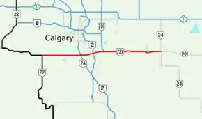 Calgary area with Highway 22X highlighted in red | ||||
| Route information | ||||
| Length | 54 km[1] (34 mi) | |||
| Major junctions | ||||
| East end | ||||
| West end | ||||
| Location | ||||
| Specialized and rural municipalities | Wheatland County, Rocky View County, Foothills No. 31 M.D. | |||
| Major cities | Calgary | |||
| Highway system | ||||
Provincial highways in Alberta
| ||||

Route description
Highway 22X begins at Highway 22 near Priddis, running east toward Calgary and becoming Spruce Meadows Trail, named after the show jumping facility of the same name that it passes. The highway crosses Macleod Trail (Highway 2A) and becomes concurrent with Stoney Trail (Highway 201).[1] It crosses the Bow River, then Deerfoot Trail, and the concurrency ends when Stoney Trail branches north and Highway 22X continues east to its end at Highway 24 east of Calgary, continuing to Gleichen as Highway 901.[1]
History
Until it was upgraded in the 2010s as part of the Stoney Trail ring road project, the Marquis of Lorne Trail portion of Highway 22X had earned a reputation of being an accident-prone road. Southward growth of Calgary had turned the small rural highway (it remained a 2-lane rural arterial road for many years) into an urban street that was not suited for high traffic volumes.
Until the late 1990s, all of Highway 22X within the City of Calgary went by the name "Marquis of Lorne Trail" (with the French variant "Marquis de Lorne" used frequently by the city, although signage retained the English version), until the owners of Spruce Meadows successfully lobbied the city to rename the portion west of Macleod Trail after the internationally known show-jumping facility. That portion of 22X is now known as "Spruce Meadows Trail". In 2009, the province announced plans to complete the southeastern portion of Stoney Trail south from Highway 1A. This project included major upgrades to the Marquis of Lorne segment of 22X west from approximately 88th Street to Macleod Trail. Completed in late 2013, the upgrade resulted in the City renaming Marquis of Lorne Trail west of 88 Street as Stoney Trail and the province also re-designated the highway as Highway 201 (the designation of the rest of Stoney Trail).[1] As of 2015, the Highway 22X designation remains in place west of Macleod Trail and east of where Stoney Trail turns northward; east of the latter the highway also retains the Marquis of Lorne Trail name.[1]
Future
Alberta Transportation has plans for the Highway 22X corridor to eventually be developed into a freeway. [3] A portion of Highway 22X west of Macleod Trail will become part of Stoney Trail (Highway 201) when construction of the southwest leg is completed in 2021.[4]
Major intersections
| Rural/specialized municipality | Location | km[1] | mi | Destinations | Notes | ||
|---|---|---|---|---|---|---|---|
| Foothills County | Priddis | 0.0 | 0.0 | Continues as Hwy 22 north | |||
| City of Calgary | 6.5 | 4.0 | 85 Street SW / 144 Street W | Calgary city limits Becomes Spruce Meadows Trail | |||
| 11.3 | 7.0 | 37 Street SW / 96 Street W | Intersection closed; former Hwy 773 south | ||||
| 12.3– 13.7 | 7.6– 8.5 | Interchange under construction; exit 10 on Hwy 201 | |||||
| Gap in Highway 22X | |||||||
| 27.8 | 17.3 | Interchange; exit 96 on Hwy 201; no access to 88 Street SE to/from Hwy 22X | |||||
| Rocky View County | Indus | 37.4 | 23.2 | ||||
| | 44.2 | 27.5 | Range Road 273 – Langdon | Former Hwy 797 | |||
| Wheatland County | | 54.1 | 33.6 | Continues as Hwy 901 east | |||
1.000 mi = 1.609 km; 1.000 km = 0.621 mi
| |||||||
See also
References
- Google (January 4, 2017). "Highway 22X in southern Alberta" (Map). Google Maps. Google. Retrieved January 4, 2017.
- "2015 Provincial Highway 1-216 Progress Chart" (PDF). Alberta Transportation. March 2015. Archived (PDF) from the original on April 10, 2016. Retrieved October 12, 2016.
- "Executive Summary" (PDF). CastleGlenn Consultants Inc. Alberta Transportation. September 2011. Archived (PDF) from the original on January 29, 2017. Retrieved January 29, 2017.
- "Agreement to Design, Build, Finance and Operate - Southwest Calgary Ring Road" (PDF). Alberta Transportation. September 13, 2016. Archived (PDF) from the original on January 29, 2017. Retrieved January 29, 2017.
