Shkhara
Shkhara (Georgian: შხარა, Russian: Шхара) is the highest point in the nation of Georgia.[4] Located in the Svaneti region along the Georgia–Russia border, Shkhara lies 88 kilometres (55 mi) north of the city of Kutaisi, Georgia's second-largest city. The summit lies in the central part of the Greater Caucasus Mountain Range, to the south-east of Mount Elbrus, Europe's highest mountain. Shkhara is the third-highest peak in the Caucasus, just behind Dykh-Tau.[5]
| Shkhara | |
|---|---|
.jpg.webp) | |
| Highest point | |
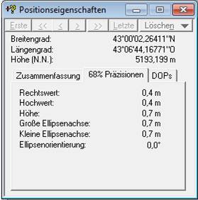
| Elevation | 5,193 m (17,000 ft) [1] |
| Prominence | 1,357 m (4,452 ft) |
| Isolation | 6 km (3.7 mi) |
| Listing |
|
| Coordinates | 43°00′02″N 43°06′44″E |
| Geography | |
Shkhara Location of Shkhara within the Caucasus mountains 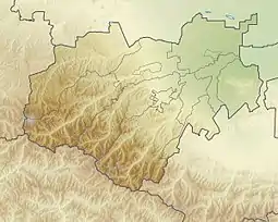 Shkhara Shkhara (Kabardino-Balkaria) 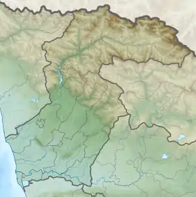 Shkhara Shkhara (Samegrelo-Zemo Svaneti) | |
| Location | Svaneti region, Georgia - Kabardino-Balkaria, Russia[2] |
| Countries | Georgia and Kabardino-Balkaria |
| Parent range | Greater Caucasus Mountains |
| Climbing | |
| First ascent | 1888 by U. Almer, J. Cockin and C. Roth[3] |
| Easiest route | Northeast Ridge: snow/ice climb (Russian grade 4b)[2][3] |
Morphology
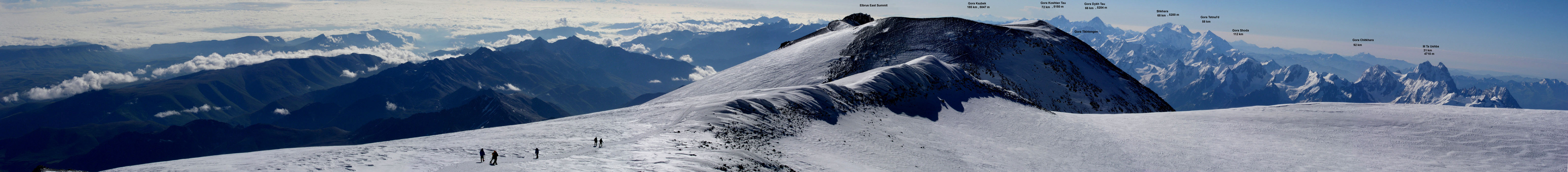
Shkhara is the high point and the eastern anchor of a massif known as the Bezingi (or Bezengi) Wall, a 12-kilometre-long (7.5 mi) ridge. It is a large, steep peak in a heavily glaciated region, and presents serious challenges to mountaineers. Its north face (on the Russian side) is 1,500 metres (4,900 ft) high and contains several classic difficult routes. The significant sub-summit Shkhara West, at 5,068 m (16,627 ft), is a climbing objective in its own right, and a traverse of the entire Bezingi Wall is considered "Europe's longest, most arduous, and most committing expedition".[3]
History
The peak was first climbed in 1888 via the North East Ridge route, by the British/Swiss team of English climber John Garford Cockin and Swiss guides Ulrich Almer and Christian Roth.[6] This route is still one of the easier and more popular routes on the mountain. The first complete traverse of the Bezingi Wall was in 1931, by the Austrians K. Poppinger, K. Moldan, and S. Schintlmeister.
References
| Wikimedia Commons has media related to Shkhara. |
- The elevation and coordinates given here are taken from a DGPS survey by Peter Schoen and Boris Avdeev in association with GeoAT. It was carried out in July 2010 and made available in November 2010. Some sources, including the Great Soviet Encyclopedia, give the estimation of only 5,068 metres (16,627 feet), but this is the correct height of the lower western summit. Soviet era 1:50,000 mapping shows a 5,158-metre spot height to the east, and this can be verified using a panoramic photograph taken from Elbrus. The true elevation is on higher ground still further east along the Shkhara ridge.
- Shkhara on Summitpost
- Audrey Salkeld, ed. (1998). World Mountaineering. Bulfinch Press. p. 70. ISBN 0-8212-2502-2.
- "Shkhara - Peakbagger.com". www.peakbagger.com. Retrieved 2019-04-13.
- Shkhara. Weather Forecast, Georgia mountain-forecast.com
- J. G. Cockin, « Shkara, Janga, and Ushba », The Alpine Journal, vol. XVI, n° 122, novembre 1893, pp. 477-494 - reproduced in Douglas W. Freshfield, The exploration of Caucasus, E. Arnold, 1896, Volume II, pp. 38-58