Supai, Arizona
Supai (Havasupai: Havasuuw) is a census-designated place (CDP) in Coconino County, Arizona, United States, within the Grand Canyon.
Supai, Arizona | |
|---|---|
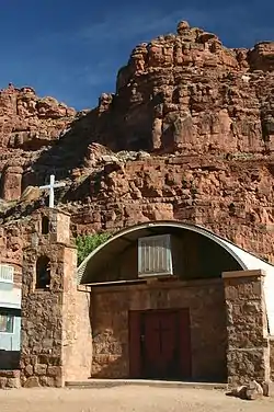 Church building in Supai | |
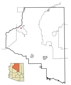 Location in Coconino County and the state of Arizona | |
| Coordinates: 36°13′27″N 112°41′38″W | |
| Country | United States |
| State | Arizona |
| County | Coconino |
| Area | |
| • Total | 1.73 sq mi (4.48 km2) |
| • Land | 1.73 sq mi (4.48 km2) |
| • Water | 0.00 sq mi (0.00 km2) |
| Elevation | 3,195 ft (974 m) |
| Population (2010) | |
| • Total | 208 |
| • Estimate (2016)[2] | N/A |
| Time zone | UTC-7 (MST) |
| ZIP code | 86435 |
| Area code | 928 |
| FIPS code | 04-71230 |
| GNIS feature ID | 0012003 |
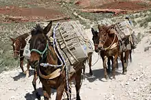
As of the 2010 census, the CDP had a population of 208.[3] The capital of the Havasupai Indian Reservation, Supai is the only place in the United States where mail is still carried out by mules.[4]
Supai has been referred to as "the most remote community" in the contiguous United States by the U.S. Department of Agriculture.[5] It is accessible only by helicopter, on foot or by mule. Supai is 8 miles (13 km) from the nearest road and has no automobiles in the community.[4]
Recent history
Tourists and some residents were evacuated from Supai and surrounding area on August 17 and 18, 2008,[6] due to flooding of Havasu Creek complicated by the failure of the earthen Redlands Dam (subsequent to the main flooding event[7][8]) after a night of heavy rainfall. Evacuees were taken to Peach Springs, Arizona.[9] More heavy rains were expected and a flash flood warning was put into effect, necessitating the evacuation, according to the National Park Service.[10] The floods were significant enough to attract coverage from international media.[9][11]
Damage to the trails, bridges, and campground was severe enough for Havasupai to close visitor access to the village, campground, and falls until the spring of 2009.[12] Further flooding in 2010 resulted in damage to repairs made previously and closures effective until May 2011.
Geography and climate

Located within the Grand Canyon, Supai is only accessible by foot, pack animal or helicopter. It is the only place in the United States where mules still carry the mail, most of which is food.[13][14]
According to the United States Census Bureau, the CDP has a total area of 1.7 square miles (4.4 km2), all land. It lies 3,195 feet (974 m) above sea level.
Climate
| Climate data for Supai, 1956–1987 | |||||||||||||
|---|---|---|---|---|---|---|---|---|---|---|---|---|---|
| Month | Jan | Feb | Mar | Apr | May | Jun | Jul | Aug | Sep | Oct | Nov | Dec | Year |
| Record high °F (°C) | 79 (26) |
87 (31) |
95 (35) |
98 (37) |
104 (40) |
112 (44) |
116 (47) |
111 (44) |
111 (44) |
102 (39) |
86 (30) |
85 (29) |
116 (47) |
| Average high °F (°C) | 52.8 (11.6) |
59.8 (15.4) |
67.7 (19.8) |
76.1 (24.5) |
85.1 (29.5) |
95.7 (35.4) |
99.0 (37.2) |
95.6 (35.3) |
90.1 (32.3) |
77.0 (25.0) |
62.8 (17.1) |
52.8 (11.6) |
76.1 (24.5) |
| Average low °F (°C) | 29.4 (−1.4) |
34.5 (1.4) |
39.2 (4.0) |
45.5 (7.5) |
53.2 (11.8) |
61.7 (16.5) |
67.1 (19.5) |
65.4 (18.6) |
58.4 (14.7) |
47.8 (8.8) |
37.4 (3.0) |
30.0 (−1.1) |
47.5 (8.6) |
| Record low °F (°C) | −1 (−18) |
5 (−15) |
13 (−11) |
23 (−5) |
29 (−2) |
36 (2) |
46 (8) |
42 (6) |
34 (1) |
19 (−7) |
0 (−18) |
−4 (−20) |
−4 (−20) |
| Average precipitation inches (mm) | 0.61 (15) |
0.63 (16) |
0.88 (22) |
0.38 (9.7) |
0.41 (10) |
0.26 (6.6) |
1.24 (31) |
1.42 (36) |
0.65 (17) |
0.61 (15) |
0.72 (18) |
0.75 (19) |
8.54 (217) |
| Average snowfall inches (cm) | 0.4 (1.0) |
0.2 (0.51) |
0 (0) |
0 (0) |
0 (0) |
0 (0) |
0 (0) |
0 (0) |
0 (0) |
0 (0) |
0.1 (0.25) |
0.6 (1.5) |
1.2 (3.0) |
| Average precipitation days (≥ 0.01 in) | 4 | 4 | 5 | 3 | 2 | 1 | 5 | 6 | 3 | 3 | 3 | 4 | 44 |
| Source: WRCC[15] | |||||||||||||
Demographics
As of the census of 2010,[3] there were 208 people and 43 households. The racial makeup of the CDP was 96.6% Native American, 0.5% White, 0.5% Other, and 2.4% of mixed race. Hispanic or Latino of any race were 4.3% of the population.
There were 43 households, out of which 34.9% were married families living together, 32.6% had a female householder with no husband present, 14.0% had a male householder with no wife present, and 18.6% were non-families. 16.3% of all households were made up of individuals, and 2.3% had someone living alone who was 65 years of age or older. The average household size was 4.84.
In the CDP the population was spread out, with 30.8% under the age of 16, 10.4% from 16 to 21, 54.8% from 21 to 65, and 4.8% who were 65 years of age or older. The median age was 25.2 years. 48.6% of the population was male; 51.4% was female.
| Historical population | |||
|---|---|---|---|
| Census | Pop. | %± | |
| 1990 | 423 | — | |
| 2010 | 208 | — | |
| U.S. Decennial Census[16] | |||
Education
There is one K-8 school in Supai, Havasupai Elementary, run by the Bureau of Indian Education. It only offers math and English classes.[17]
As of 2017, around 20% of the school's students graduate from high school.[18]
Access
Supai can be reached by hiking 8 miles (13 km), descending 2,004 feet (611 m) in elevation from Hualapai Hilltop through the Hualapai Canyon.[19] Alternatively, the AirWest Helicopters service schedules flights from Hualapai Hilltop to Supai. Hualapai Hilltop is located about 70 miles (110 km) from the community of Peach Springs, along paved BIA Road 18.
Services
Supai has one small, air-conditioned lodge (Havasupai Lodge), a convenience store and a cafe.[20]
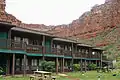 Guest rooms at Havasupai Lodge
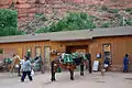 Mule train in front of the convenience store
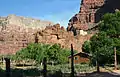 Water tanks above the village, supplying water pressure for plumbing
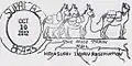 Supai AZ postmark, unique for its "mule train" design
References
- "2016 U.S. Gazetteer Files". United States Census Bureau. Retrieved July 18, 2017.
- "Population and Housing Unit Estimates". Retrieved June 9, 2017.
- "Profile of General Population and Housing Characteristics: 2010 Demographic Profile Data (DP-1): Supai CDP, Arizona". United States Census Bureau. Retrieved December 8, 2011.
- Bill Geist (January 23, 2000). "Special Delivery: Mail By Mule". CBS News Sunday Morning. CBS News. Retrieved September 30, 2009.
- "USDA Rural Utilities Administrator Visits Supai Tribe in Arizona to Announce a Recovery Act Broadband Project". U.S. Department of Agriculture. Retrieved July 16, 2016.
- Chris Dolmetsch (August 18, 2008). "Grand Canyon Flooding Forces Evacuations, Searches (Update2)". Bloomberg News. Retrieved September 30, 2009.
- "Redlands dam and Grand Canyon flooding". Arizona Geology, blog of the State Geologist of Arizona. Retrieved April 19, 2018.
- Dougherty, John. "New Interest in Warning System After Grand Canyon Flood". The New York Times. The New York Times Company. Retrieved April 19, 2018.
- Rajesh Mirchandani (August 17, 2008). "Dam evacuations in Grand Canyon". BBC. Retrieved August 17, 2008.
- Associated Press (August 17, 2008). "Hikers located after Grand Canyon flood". NBC News. Retrieved September 30, 2009.
- "Honderden geëvacueerd uit Grand Canyon". Dutch online news site nu.nl. August 18, 2008. Retrieved September 30, 2009.
- "Camping". HavasupaiTribe.com. February 19, 2009. Archived from the original on February 19, 2009. Retrieved September 30, 2009.
- Smithsonian Insider (August 25, 2016). "In the Grand Canyon, the U.S. Postal Service still delivers mail by mule".
- USPS (April 29, 2016). "Mule Mail".
- "Station Name: SUPAI, ARIZONA (028343)". Western Regional Climate Center. Retrieved April 26, 2013.
- "Census of Population and Housing". Census.gov. Retrieved June 4, 2016.
- Gannon, Emma (January 17, 2017). "Havasupai Parents Demand Fixes to Wretched School". Retrieved August 11, 2020.
- Woods, Alden. "A hidden tribe, a disastrous school and finally, a cry for help". The Arizona Republic. Retrieved August 11, 2020.
- Witt, Greg (2010). Exploring Havasupai: A Guide to the Heart of the Grand Canyon. Birmingham, Alabama: Menasha Ridge Press. p. 76. ISBN 978-0-89732-654-4.
- Witt, Greg (2010). Exploring Havasupai: A Guide to the Heart of the Grand Canyon. Birmingham, Alabama: Menasha Ridge Press. pp. 88–89. ISBN 978-0-89732-654-4.
External links
![]() Media related to Supai, Arizona at Wikimedia Commons
Media related to Supai, Arizona at Wikimedia Commons
Municipalities and communities of Coconino County, Arizona, United States | ||
|---|---|---|
| Cities | 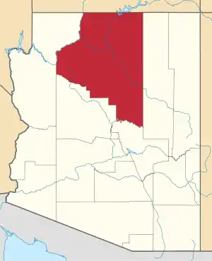 | |
| Towns | ||
| CDPs | ||
| Populated places |
| |
| Indian reservations | ||
| Ghost towns | ||
| Footnotes | ‡This populated place also has portions in an adjacent county or counties | |
| ||
| Authority control |
|
|---|