Tarner Island
Tarner Island is a triangular shaped island in Loch Bracadale just off the coast off the Harlosh peninsula of Skye in Scotland.[1][2] It is about 28 hectares (69 acres) in extent.
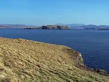
Looking south east from Harlosh Point, to Tarner Island, over Loch Bracadale.
| Location | |
|---|---|
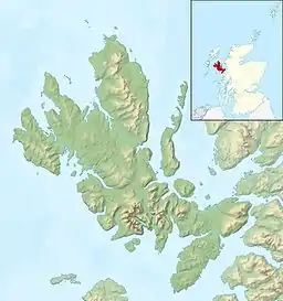 Tarner Island Tarner Island shown relative to Skye | |
| OS grid reference | NG299391 |
| Coordinates | 57.362°N 6.493°W |
| Physical geography | |
| Island group | Skye |
| Area | 28 ha (69 acres) |
| Highest elevation | 56 m (184 ft)[1] |
| Administration | |
| Sovereign state | United Kingdom |
| Country | Scotland |
| Council area | Highland |
| Demographics | |
| Population | 0 |
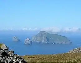
The coastline is largely cliff-lined and rocky and there is a natural arch to the north. Tarner Island is only about 1 kilometre (5⁄8 mile) from mainland Skye and there are several skerries including Sgeir Mhòr and Sgeir Bheag that lies just offshore to the north east between the island and Colbost Head.[1] Wiay and the tidal islet of Oronsay lie about 2 km (1 1⁄4 mi) to the south.
Notes
- "Get-a-Map". Ordnance Survey. Retrieved 9 December 2009.
- "Tarner Island". Gazetteer for Scotland. Retrieved 9 December 2009.
| Wikimedia Commons has media related to Tarner Island. |
|  | ||||||||||||||||
|
| |||||||||||||||||
| |||||||||||||||||
| |||||||||||||||||
| |||||||||||||||||
| |||||||||||||||||
| |||||||||||||||||
| |||||||||||||||||
This article is issued from Wikipedia. The text is licensed under Creative Commons - Attribution - Sharealike. Additional terms may apply for the media files.
