Tirari–Sturt stony desert
The Tirari–Sturt stony desert is a deserts and xeric shrublands ecoregion in central Australia.[1]
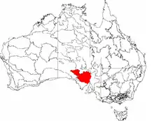
| Tirari-Sturt stony desert | |
|---|---|
 | |
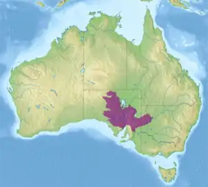 Ecoregion territory (in purple) | |
| Ecology | |
| Realm | Australasian |
| Biome | deserts and xeric shrublands |
| Borders | |
| Geography | |
| Area | 376,850 km2 (145,500 sq mi) |
| Country | Australia |
| States | New South Wales, Northern Territory, and South Australia |
| Conservation | |
| Conservation status | Vulnerable |
Location and description
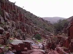
The Tirari–Sturt stony desert ecoregion contains the gibber plains (desert pavement) and red sands of the large Sturt Stony Desert, the Tirari Desert to its southwest and the Flinders and Gawler Ranges to the south. The Tirari has more sand dunes than the Sturt Stony Desert and has also been the site of some important fossil findings. Towns of the ecoregion include the opal mining centre of Coober Pedy, famous for its underground dwellings. the climate is very hot with summer temperatures reaching 50 °C.
The region consists of the Stony Plains, Gawler, Flinders Lofty Block and the Broken Hill Complex bioregions of the Interim Biogeographic Regionalisation for Australia (IBRA).[2][3]
Flora and fauna
As well as stony plain and sands there are areas of chenopod, mallee and mulga wooded scrubland. The region is home to a variety of wildlife that has adapted to the hot dry conditions including the wedge-tailed eagles, yellow-footed rock wallaby and western grey kangaroos of the Flinders Ranges.
The desert proper is uninhabitable and the environment there remains undamaged, while the greener fringe are used for sheep grazing.
References
- "Tirari-Sturt stony desert". Terrestrial Ecoregions. World Wildlife Fund.
- Environment Australia. "Revision of the Interim Biogeographic Regionalisation for Australia (IBRA) and Development of Version 5.1 – Summary Report". Department of the Environment and Water Resources, Australian Government. Archived from the original on 5 September 2006. Retrieved 31 January 2007. Cite journal requires
|journal=(help) - IBRA Version 6.1 data