U.S. Route 70 in Tennessee
U.S. Route 70 (US 70) enters the state of Tennessee from Arkansas via the Memphis & Arkansas Bridge in Memphis, and runs west to east across 21 counties in all three grand divisions of Tennessee, with a total length of 478.48 miles (770.04 km), to end at the North Carolina state line in eastern Cocke County. Along the route, US 70 is accompanied with various U.S. and state highways, including those in three of the state's four major cities (e.g. Memphis, Nashville, and Knoxville).
| ||||
|---|---|---|---|---|
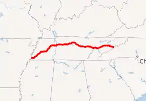
Route of US 70 in Tennessee highlighted in red | ||||
| Route information | ||||
| Maintained by TDOT | ||||
| Length | 478.48 mi (770.04 km) | |||
| Existed | 1926–present | |||
| Major junctions | ||||
| West end | ||||
| ||||
| East end | ||||
| Location | ||||
| Counties | Shelby, Fayette, Tipton, Haywood, Madison, Carroll, Benton, Humphreys, Dickson, Cheatham, Davidson, Wilson, DeKalb, White, Cumberland, Roane, Loudon, Knox, Sevier, Jefferson, Cocke | |||
| Highway system | ||||
| ||||
Route description
Memphis to Nashville
US 70 enters the state via the Memphis & Arkansas Bridge on I-55, along with U.S. Routes 61, 64, and 79, along with SR 1. US 70 follows E.H. Crump Avenue, Danny Thomas Boulevard, Union Avenue, East Parkway, and Summer Avenue through Memphis, mostly accompanied with US 64 and US 79, along with some of SR 3.
While US 64 departs from US 70/79 in Bartlett, US 79 remains with US 70 from there to Brownsville, in Haywood County.[1] US 70 turns eastward to go through the cities of Jackson, Huntingdon, and Camden before crossing the Tennessee River. After that, it then continues eastward through Waverly, Dickson, and Kingston Springs before making entry into Nashville.[2]
Much of US 70 from Memphis to the west side of Nashville is accompanied by the secret designation of Tennessee State Route 1, with the exception of a few streets in downtown Memphis. US 70 has two concurrencies with SR 1 in the western half of the state, one in the downtown area, and the other from the east side of Memphis to western Davidson County. The brief one in downtown Nashville is the third SR 1 concurrency along with US 70S/US 431 along Broadway.[3][4][5]
Nashville area
In Nashville, US 70 begins to be paired with SR 24 after lending SR 1 to the Memphis-Bristol Highway (U.S. Route 70S). US 70 continues into downtown Nashville, following Charlotte Avenue, 14th Avenue (13th Avenue for US 70's westbound lanes along I-40/I-65), Broadway, First Avenue, and Hermitage Avenue. At the 14th Avenue intersection on Charlotte Avenue, US 70 acts as collector/distributor roads for I-40/I-65 for two blocks before joining U.S. 431 and U.S. 70S on a brief overlap.
After US 431 and US 70S splits from the main route on Broadway, US 70 progresses eastward, roughly paralleling the Cumberland River, ducking under the western split of I-40 and I-24, and continuing to an interchange with SR 155 (Briley Parkway) east of downtown, and then Old Hickory Boulevard in Hermitage.[6]
Mount Juliet to Lenoir City
East of Nashville, US 70 enters Wilson County near Mount Juliet. US 70 then bypasses the downtown area of Lebanon with intersections with US 231 (SR 10) and US 70N (SR 24), and including a concurrency with SR 141 before turning southeast to DeKalb and White Counties. US 70 is paired with Tennessee State Route 26 from Lebanon all the way to the state route's terminus in Sparta. Near the US 70S junction in Sparta, SR 1 returns to US 70 for its route from there, to Crossville, to the Harriman/Kingston area, all the way into the north side of Lenoir City, and after US 11 (SR 2) joins US 70, it eventually enters the Knoxville area.[7]
Knoxville to the North Carolina border
In downtown Knoxville, US 70, along with US 11, follows Neyland Drive, south of the campus of University of Tennessee, then exits onto Hall of Fame Drive north to Magnolia Drive. US 11/70 follows Magnolia Drive out of downtown. At the US 11W/11E split, US 70 begins to follow US 11E, while SR 1 follows US 11W. Before crossing the Tennessee River for a second time, US 25W begins to follow US 70 (SR 9) from the east side of Knoxville until it merges with US 25E at Newport. US 70 carries US 25 into North Carolina east of Newport.[8]
Major intersections
The mileposts listed in the following table is only an estimated calculation. Actual mile markers may vary.
| County | Location | mi | km | Destinations | Notes | |
|---|---|---|---|---|---|---|
| Mississippi River | 0.00 | 0.00 | Continuation into Arkansas | |||
| Memphis & Arkansas Bridge; Arkansas–Tennessee state line; Begin first concurrency with unsigned | ||||||
| Shelby | Memphis | 0.6 | 0.97 | I-55 Exit 12A-B, end concurrency with I-55 | ||
| 1.3 | 2.1 | Western terminus of SR 4; eastern end of US 61 concurrency; western end of unsigned SR 14 concurrency | ||||
| 2.2 | 3.5 | Western terminus of US 78 and unsigned SR 278 | ||||
| 2.6 | 4.2 | Western end of unsigned SR 3 concurrency; eastern end of unsigned SR 14 concurrency; follows one-way pair | ||||
| 3.0 | 4.8 | Western end of US 51 concurrency; End first concurrency with unsigned SR 1 | ||||
| 4.2 | 6.8 | No direct access to north(west)bound I-240 nor from south(east)bound I-240 (both signed at Madison Avenue); I-240 exit 30 | ||||
| 4.4 | 7.1 | Eastern end of US 51 and unsigned SR 3 concurrency; western terminus of unsigned | ||||
| 6.6 | 10.6 | Western end of unsigned SR 277 concurrency; eastern end of unsigned SR 23 concurrency | ||||
| 7.1 | 11.4 | Western end of wrong-way SR 57 concurrency; western terminus of US 72 | ||||
| 7.7 | 12.4 | Sam Cooper Boulevard east to | Western terminus of Sam Cooper Boulevard | |||
| 7.8 | 12.6 | Northern terminus of unsigned SR 277; eastern end of wrong-way SR 57 concurrency; Western end of SR 1 concurrency #2 | ||||
| 13.3 | 21.4 | No access to I-40 Eastbound; I-40 exit 12A | ||||
| 13.6– 13.8 | 21.9– 22.2 | Bridge over the Wolf River | ||||
| Bartlett | 17.9 | 28.8 | Eastern end of US 64 concurrency | |||
| Memphis | 21.2 | 34.1 | Northern terminus of SR 177 | |||
| 30.2– 30.5 | 48.6– 49.1 | Interchange; Future I-269 | ||||
| Arlington | 31.1 | 50.1 | Western end of SR 205 concurrency | |||
| 31.9 | 51.3 | Eastern end of SR 205 concurrency | ||||
| 33.5– 33.6 | 53.9– 54.1 | Bridge over the Loosahatchie River | ||||
| Fayette | Gallaway | 35.6 | 57.3 | Northern terminus of SR 196 | ||
| Braden | 39.7 | 63.9 | Western end of SR 59 concurrency | |||
| Tipton | Mason | 42.7 | 68.7 | Eastern end of SR 59 concurrency | ||
| Haywood | Stanton | 50.8 | 81.8 | Northern terminus of SR 222 | ||
| 50.9 | 81.9 | |||||
| | 55.9– 56.0 | 90.0– 90.1 | Judge John B. Bond Memorial Bridge over the Hatchie River | |||
| Brownsville | 61.6 | 99.1 | Western end of SR 19 concurrency; Old US 79/70 straight ahead | |||
| 64.1 | 103.2 | Western end of SR 76 concurrency | ||||
| 64.9 | 104.4 | Eastern end of SR 19 concurrency | ||||
| 65.4 | 105.3 | Northern end of US 79 concurrency; Western terminus of US 70A | ||||
| 73.6– 73.8 | 118.4– 118.8 | I-40 Exit 66 | ||||
| Madison | | 75.9 | 122.1 | |||
| Jackson | 84.1 | 135.3 | Provides access to McKellar-Sipes Regional Airport | |||
| 88.1– 88.2 | 141.8– 141.9 | Bridge over the South Fork of the Forked Deer River | ||||
| 88.8 | 142.9 | Western end of US 45 Bypass (SR 186) concurrency | ||||
| 90.3 | 145.3 | Southern terminus of US 45 Bypass (SR 186); eastern end of US 45 Bypass (SR 186) concurrency | ||||
| 91.2 | 146.8 | Western terminus of SR 198 | ||||
| 93.2 | 150.0 | Whitehall Street / Dr. Fe Wright Drive | US 70/SR 1 -- right turn | |||
| 94.1 | 151.4 | Southern end of US 412 Business/SR 20 concurency | ||||
| 96.9 | 155.9 | Northern end of US 412 Bus./SR 20 concurrency; Eastern terminus of US 412 Business; Southern end of US 412 concurrency | ||||
| 97.2– 97.3 | 156.4– 156.6 | Northern end of US 412 concurrency | ||||
| Spring Creek | 104.2 | 167.7 | Western end of 75 ft. concurrency with SR 152 | |||
| 104.25 | 167.77 | Eastern end of 75 ft. concurrency with SR 152 | ||||
| Carroll | Cedar Grove | 110.3 | 177.5 | Southern end of SR 104 concurrency | ||
| 110.8 | 178.3 | Southern terminus of SR 220 | ||||
| | 113.5 | 182.7 | Northern end of SR 104 concurrency | |||
| | 114.2 | 183.8 | Western terminus of SR 424 | |||
| Huntingdon | 125.8 | 202.5 | Western end of SR 22 concurrency | |||
| 127.2 | 204.7 | Southern terminus of SR 22 Business | ||||
| 127.4 | 205.0 | Eastern end of SR 22 concurrency; interchange | ||||
| 129.4 | 208.2 | Eastern terminus of US 70A; interchange | ||||
| Rosser | 132.0 | 212.4 | Southern terminus of SR 219 | |||
| Hollow Rock | 136.4 | 219.5 | Western end of SR 114 concurrency | |||
| 136.7 | 220.0 | Eastern end of SR 114 concurrency | ||||
| Bruceton | 139.3 | 224.2 | Bridge over the Big Sandy River | |||
| Benton | Camden | 144.4 | 232.4 | Western terminus of US 70 Business | ||
| 146.0 | 235.0 | |||||
| 147.8 | 237.9 | |||||
| 148.7 | 239.3 | Eastern terminus of US 70 Business | ||||
| Kentucky Lake | 152.8 153.3 | 245.9 246.7 | Hickman Lockhart Bridge over the Tennessee River | |||
| Humphreys | New Johnsonville | 155.3 | 249.9 | County Road 929 -- TVA Johnsonville | Interchange | |
| | 158.1 | 254.4 | Old Johnsonville Road -- Johnsonville State Historic Park | |||
| Waverly | 163.5 | 263.1 | West Main Street to | Old US 70/SR 1 | ||
| 166.3 | 267.6 | Northern terminus of SR 13 Spur | ||||
| 167.2 | 269.1 | East Main Street | Old US 70/SR 1 | |||
| McEwen | 175.5 | 282.4 | Southern terminus of SR 231 | |||
| Dickson | Dickson | 188.7 | 303.7 | Western end of SR 46/235 concurrency | ||
| 188.8 | 303.8 | Western terminus of US 70 Business; Eastern end of SR 235 concurrency[9] | ||||
| 189.9– 190.1 | 305.6– 305.9 | Interchange | ||||
| 190.4 | 306.4 | Eastern end of SR 46 concurrency | ||||
| 190.9 | 307.2 | Eastern terminus of US 70 Business; southern terminus of SR 235 | ||||
| 192.5 | 309.8 | Western terminus of SR 96 | ||||
| White Bluff | 198.8 | 319.9 | Western end of SR 47 concurrency | |||
| 199.3 | 320.7 | Eastern end of SR 47 concurrency | ||||
| Cheatham | Kingston Springs | 207.3 | 333.6 | Joe A. Taylor Memorial Bridge over the Harpeth River | ||
| 207.4 | 333.8 | Cedar Hill Road - Mound Bottom, Narrows of the Harpeth River State Park | ||||
| Pegram | 209.7 | 337.5 | Western end of SR 249 concurrency | |||
| 209.9 | 337.8 | Eastern end of SR 249 concurrency | ||||
| Davidson | Nashville | 215.4 | 346.7 | Western termini of US 70S and SR 24; eastern end of SR 1 concurrency; western end of SR 24 concurrency | ||
| 219.1 | 352.6 | |||||
| 220.8– 221.1 | 355.3– 355.8 | I-40 Exit 201 | ||||
| 223.6 | 359.8 | Beltway around Nashville | ||||
| 223.8 | 360.2 | Bridge over Richland Creek | ||||
| 227.3 | 365.8 | US 70/SR 24 gets divided between 14th and 13th Avenues serving as local-express lanes; I-40 Exits 209 and 209A; I-40 west accessible via 13th Avenue only | ||||
| 227.7 | 366.4 | US 70/SR 24 division ends; Western end of US 70S/431/SR 1 concurrency; On-ramp to I-40 EB/I-65 SB accessed via 14th Avenue South | ||||
| 227.72 | 366.48 | I-40 WB/I-65 NB accessed via 13th Avenue North | ||||
| 228.1 | 367.1 | Eastern end of US 70S/431/SR 1 concurrency | ||||
| 230.6 | 371.1 | Bridge over Mill Creek | ||||
| 233.9– 234.1 | 376.4– 376.7 | SR 155/Briley Parkway Exit 8 | ||||
| Donelson | 235.5 | 379.0 | Northern terminus of SR 255; provides access to Nashville International Airport | |||
| Hermitage | 237.7– 237.8 | 382.5– 382.7 | Elmer Disspayne Sr. Memorial Bridge over the Stones River | |||
| 238.0 | 383.0 | Western terminus of SR 265 | ||||
| 239.0 | 384.6 | |||||
| Wilson | Mount Juliet | 245.7 | 395.4 | Northern terminus of SR 171 | ||
| | 250.5 | 403.1 | Interchange | |||
| Lebanon | 256.1 | 412.2 | Eastern end of unsigned SR 24 concurrency; Western terminus of US 70 Bus and unsigned | |||
| 258.8 | 416.5 | |||||
| 259.6 | 417.8 | Northern terminus of SR 266 | ||||
| 260.0 | 418.4 | Western end of SR 141 concurrency | ||||
| 260.5 | 419.2 | Eastern terminus of US 70 Bus; Western terminus of US 70N | ||||
| 260.54 | 419.30 | Eastern end of SR 141 concurrency | ||||
| 262.04– 262.2 | 421.71– 422.0 | I-40 Exit 239A-B eastbound and 239 westbound | ||||
| | 268.7 | 432.4 | Eastern terminus of SR 265; provides access to Cedars of Lebanon State Park | |||
| Watertown | 272.8 | 439.0 | Northern terminus of SR 267 | |||
| DeKalb | Alexandria | 279.6 | 450.0 | Western end of SR 53 concurrency | ||
| | 283.5 | 456.2 | Western end of SR 96 concurrency | |||
| Liberty | 284.9 | 458.5 | Eastern end of SR 53 concurrency | |||
| 285.8 | 460.0 | Bridge over Smith Fork Creek | ||||
| | 290.3 | 467.2 | Eastern end of SR 96 concurrency | |||
| Smithville | 293.1 | 471.7 | Partial loop around Smithville | |||
| 295.7 | 475.9 | Northern terminus of SR 146 | ||||
| 296.0 | 476.4 | |||||
| | 302.9– 302.3 | 487.5– 486.5 | Bridge over Center Hill Lake/Caney Fork River | |||
| White | | 310.8 | 500.2 | Provides access to Rock Island State Park | ||
| Sparta | 315.9– 316.1 | 508.4– 508.7 | Eastern terminus of US 70S; interchange | |||
| 316.6 | 509.5 | Western end of SR 1 concurrency #4; Eastern terminus of SR 26 | ||||
| 316.7 | 509.7 | Old SR 111; southern terminus of SR 289 | ||||
| 317.1 | 510.3 | Bridge over the Calfkiller River | ||||
| 317.4 | 510.8 | Southern terminus of SR 84 | ||||
| Cumberland | Pleasant Hill | 336.4 | 541.4 | Bridge over the Caney Fork River | ||
| Crossville | 339.9 | 547.0 | ||||
| 341.4 | 549.4 | Western terminus of SR 462 | ||||
| 342.8 | 551.7 | Bridge over the Obed River | ||||
| 343.3 | 552.5 | |||||
| 343.7 | 553.1 | Partial beltway around downtown Crossville | ||||
| 344.7 | 554.7 | Western end of SR 101 concurrency | ||||
| 344.75 | 554.82 | |||||
| 347.2 | 558.8 | Northern end of SR 101 concurrency; southern terminus of SR 392 | ||||
| Crab Orchard | 354.8 | 571.0 | Market Street to | I-40 Exit 329 | ||
| | 357.4 | 575.2 | Renegade Mountain Parkway - Renegade Mountain | |||
| Ozone | 359.3 | 578.2 | Ozone Falls State Natural Area Trailhead | |||
| Westel | 364.1 | 586.0 | Southern terminus of SR 299 | |||
| Roane | Rockwood | 367.4 | 591.3 | Southern end of US 27/SR 29 concurrency | ||
| 370.2 | 595.8 | Northern end of US 27 concurrency; western terminus of SR 61 | ||||
| | 373.6 | 601.3 | Southern terminus of SR 382; provides access to Roane State Community College | |||
| Midtown | 377.2 | 607.0 | Northern end of SR 29 concurrency | |||
| Kingston | 378.4– 378.6 | 609.0– 609.3 | Thomas W. Pickel Jr. Memorial Bridge over Watts Bar Lake/Clinch River | |||
| 381.3 | 613.6 | |||||
| 385.2 | 619.9 | Southern terminus of SR 326 | ||||
| Loudon | Lenoir City | 395.8 | 637.0 | |||
| Dixie Lee Junction | 399.9 | 643.6 | Western end of US 11 concurrency; eastern terminus of SR 2 | |||
| Knox | Farragut | 404.5 | 651.0 | Western terminus of SR 332 | ||
| 405.6 | 652.7 | Southern terminus of SR 131 | ||||
| Knoxville | 406.7– 406.9 | 654.5– 654.8 | I-140 exit 1 A/B eastbound; exit 1 westbound | |||
| 413.8 | 665.9 | |||||
| 417.2 | 671.4 | Kingston Pike to Cumberland Avenue - Downtown Knoxville | Former route of US 11/US 70/SR 1 through downtown Knoxville; western end of now unsigned | |||
| 417.3– 417.4 | 671.6– 671.7 | Interchange | ||||
| 417.9 | 672.5 | Western terminus of SR 450 | ||||
| 419.1 | 674.5 | Lake Loudon Boulevard - University of Tennessee, Thompson-Boling Arena, Neyland Stadium | ||||
| 419.5 | 675.1 | Walnut Street - Knoxville Civic Coliseum, William Blount Mansion, James White Fort | Intersection with exit to Tennessee Riverboat Landing | |||
| 419.6 | 675.3 | Volunteer Landing | Eastbound exit only | |||
| 419.7– 420.1 | 675.4– 676.1 | Eastbound exit and westbound entrance; eastern end of now unsigned SR 158 concurrency | ||||
| 420.1 | 676.1 | Western end of unsigned SR 71 concurrency; interchange; follows Hall Of Fame Drive | ||||
| 420.4 | 676.6 | W Church Avenue - Knoxville Civic Coliseum, Downtown | ||||
| 420.8 | 677.2 | Summit Hill Drive - Downtown | To | |||
| 421.2 | 677.9 | East 5th Avenue - Downtown Hall of Fame Drive (SR 71 north) | East 5th Avenue is the former route of US 11/US 70/SR 1; eastern end of unsigned SR 71 concurrency; follows Magnolia Avenue | |||
| 423.5 | 681.6 | Eastern end of SR 1 concurrency; US 11 splits into US 11E and US 11W; western end of US 11E and unsigned SR 168 concurrency; eastern terminus of unsigned | ||||
| 425.5– 425.6 | 684.8– 684.9 | Western end of US 25W/SR 9 concurrency | ||||
| 426.2– 426.4 | 685.9– 686.2 | Bridge over the Holston River | ||||
| 426.5 | 686.4 | Eastern end of SR 168 concurrency | ||||
| Carter | 431.6 | 694.6 | Eastern end of US 11E concurrency; western terminus of SR 34 | |||
| Sevier | | 438.2 | 705.2 | Western end of SR 139 concurrency | ||
| Jefferson | Four Points | 439.7 | 707.6 | Eastern end of SR 139 concurrency; Snyder Road is old SR 66 | ||
| Dandridge | 447.4– 447.6 | 720.0– 720.3 | Western end of SR 66 concurrency; I-40 exit 415 | |||
| 450.7 | 725.3 | Western end of SR 92 concurrency | ||||
| 451.3 | 726.3 | Eastern end of SR 92 concurrency | ||||
| 452.1 | 727.6 | Eastern end of SR 66 concurrency | ||||
| 455.7 | 733.4 | Southern terminus of SR 113 | ||||
| | 455.9– 456.3 | 733.7– 734.3 | Bridge over Douglas Lake/French Broad River | |||
| Reidtown | 461.5 | 742.7 | Eastern terminus of SR 363 | |||
| Cocke | | 462.5 | 744.3 | Western end of unsigned SR 35 concurrency; northern terminus of US 411 | ||
| | 463.2– 463.5 | 745.4– 745.9 | I-40 exit 432A-B | |||
| Newport | 465.9 | 749.8 | Southern termini of US 25W and US 25E; western end of unsigned SR 32 concurrency; US 70 continues with | |||
| 467.0 | 751.6 | Eastern end of SR 32 concurrency; Western end of US 321 concurrency | ||||
| 467.3 | 752.0 | Eastern end of US 321 and SR 35 concurrency | ||||
| 468.2 | 753.5 | John W. Fisher Bridge over the Pigeon River | ||||
| 468.3 | 753.7 | Northern terminus of SR 73 | ||||
| | 471.7– 472.0 | 759.1– 759.6 | Major J.T. Huff Bridge over the French Broad River | |||
| | 475.9 | 765.9 | Southern terminus of SR 340 | |||
| Del Rio | 478.5 | 770.1 | Western end of SR 107 concurrency | |||
| | 481.7 | 775.2 | Eastern end of SR 107 concurrency | |||
| Cherokee National Forest | 482.8– 482.9 | 777.0– 777.2 | Wolf Creek Bridge over the French Broad River | |||
| Madison | 486.1 | 782.3 | Continuation into North Carolina; end concurrency with unsigned | |||
1.000 mi = 1.609 km; 1.000 km = 0.621 mi
| ||||||
Related routes
Supplemental routes
- U.S. Route 70 Business (Huntingdon, Tennessee)
- U.S. Route 70 Business (Camden, Tennessee)
- Tennessee State Route 391
- U.S. Route 70 Business (Dickson, Tennessee)
- U.S. Route 70 Business (Lebanon, Tennessee)
Tennessee State Route 1
Tennessee State Route 9
Tennessee State Route 26
| |
|---|---|
| Location | Lebanon--Sparta |
| Length | 59.25 mi (95.35 km) |
State Route 26 (SR 26) runs concurrently with US 70 for its entire existence through Wilson, De Kalb and White Counties in Middle Tennessee. The 59.25 miles (95.35 km) long state highway runs from Lebanon downtown Sparta.
History
It was signed solely as SR 26 until sometime in the 1960s or 1970s when US 70 was designated on that alignment, but retains the state route designation as a secret, or hidden designation.[10]
See also
References
- Tennessee Department of Transportation (2017). Tennessee's Official Transportation Map [front] (PDF) (Map) (2017 ed.). Nashville: Tennessee Department of Transportation. § D2 and D3. Retrieved February 28, 2017.
- Tennessee Department of Transportation (2017). Tennessee's Official Transportation Map [front] (PDF) (Map) (2017 ed.). Nashville: Tennessee Department of Transportation. § C4-C5 and B5-B8. Retrieved February 28, 2017.
- Rand McNally (2016). "Tennessee" (Map). The Road Atlas (2016 Walmart ed.). 1 in≈19 mi. Chicago: Rand McNally. p. 94. Memphis inset. §§ K2-K5. ISBN 0-528-01329-7.
- Rand McNally (2016). "Tennessee" (Map). The Road Atlas (2016 Walmart ed.). 1 in≈19 mi. Chicago: Rand McNally. p. 94. Nashville inset. §§ K7-K8. ISBN 0-528-01329-7.
- Tennessee Department of Transportation (2017). Tennessee's Official Transportation Map [front] (PDF) (Map) (2017 ed.). Nashville: Tennessee Department of Transportation. § E2, D2-D4, C4-C6, and B6-B9. Retrieved February 28, 2017.
- Rand McNally (2016). "Tennessee" (Map). The Road Atlas (2016 Walmart ed.). 1 in≈19 mi. Chicago: Rand McNally. p. 94. Nashville inset. §§ L5-L6 and K6-K10. ISBN 0-528-01329-7.
- Tennessee Department of Transportation (2017). Tennessee's Official Transportation Map [back] (PDF) (Map) (2017 ed.). Nashville: Tennessee Department of Transportation. § B9 and C9-C13. Retrieved February 28, 2017.
- Tennessee Department of Transportation (2017). Tennessee's Official Transportation Map [back] (PDF) (Map) (2017 ed.). Nashville: Tennessee Department of Transportation. § C13-C15. Retrieved February 28, 2017.
- Google (July 24, 2016). "U.S. Route 70 in Tennessee" (Map). Google Maps. Google. Retrieved July 24, 2016.
- Rand McNally Road Atlas 1959, page 38.
External links
![]() Media related to U.S. Route 70 in Tennessee at Wikimedia Commons
Media related to U.S. Route 70 in Tennessee at Wikimedia Commons
| Previous state: Arkansas |
Tennessee | Next state: North Carolina |