Strawberry Plains, Tennessee
Strawberry Plains is an unincorporated community and census-designated place in Jefferson, Knox, and Sevier counties in the State of Tennessee, United States.[3] Before 2010, it was treated by the United States Census Bureau as a census county division. It is included in both the Knoxville Metropolitan Statistical Area and the Morristown Metropolitan Statistical Area.[4]
Strawberry Plains, Tennessee | |
|---|---|
| Strawberry Plains | |
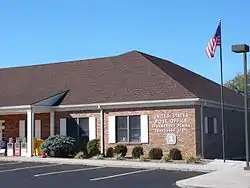 Post office in Strawberry Plains | |
| Nickname(s): Straw Plains[1] | |
 Strawberry Plains  Strawberry Plains | |
| Coordinates: 36°3′47″N 83°41′10″W | |
| Country | United States |
| State | Tennessee |
| Counties | Jefferson, Knox, Sevier |
| Settled | 1785[2] |
| Elevation | 928 ft (283 m) |
| Population | |
| • Total | 4,667 |
| Time zone | UTC-5 (Eastern (EST)) |
| • Summer (DST) | UTC-4 (EDT) |
| ZIP codes | 37871, 37914, 37924 |
| Area code(s) | 865 |
| FIPS code | 47093 |
| GNIS feature ID | 1303876,[1] 2804643[3] |
History
Strawberry Plains is said to be named for the wild strawberries that grew there in abundance when white settlers from North Carolina first arrived in the area.[2] According to a history of the community written by local high school students circa 1935, the name Straw Plains was a shorthand name used by railroad porters and flagmen on trains that passed through Strawberry Plains, and that came to be used as the name of the local railroad depot and on some local post office postmarks.[2]
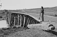
Early in the Civil War, in 1861, the railroad bridge at Strawberry Plains was one target of Union sympathizers who aimed to burn several East Tennessee bridges to hinder Confederate military progress. The conspirators failed in their efforts to burn the Strawberry Plains bridge, but succeeded in their attacks of some of their other targets. In 1864, the bridge was destroyed in a artillery duel between Confederate and Union forces.[5]
Through much of the 20th century, Strawberry Plains was the site of a Tennessee limestone quarry and an underground zinc mine.[2] The zinc mine shut down in 2001, but reopened in 2006.[6] In December 2008 it was announced that the mine would close again in February 2009.[7]
Geography
Strawberry Plains is located on the bank of the Holston River. According to the United States Geological Survey, a variant is Straw Plains.[1] Strawberry Plains has been the site of a post office since 1806.[2] The zip code is 37871, though parts of Strawberry Plains are located in the zip codes 37914 and 37924.
Economy
In September 2007, the Tennessee Bureau of Investigation announced plans to build an office facility and crime lab in Strawberry Plains at Interstate 40 exit 398, having an estimated cost of more than $10 million.[8] The 33,000-square-foot facility was completed in July 2009.[9]
Exit 398 on I-40 at Strawberry Plains Pike has seen a increased amount of development since the 1990s. There are several hotels, restaurants and gas stations, with more under construction. With the increased growth around the interchange, the location has since been annexed into the City of Knoxville.[10]
The Tennessee Department of Transportation administrative office for Region 1 is also located on Strawberry Plains Pike.[11]
Strawberry Plains has a Food City supermarket, a Price Less Foods supermarket, a Family Dollar store, three Dollar General stores and several pharmacies.[12]
Plans for a mixed-use town centre in the Carter area of Strawberry Plains have been proposed by the Knoxville-Knox County Metropolitan Planning Commission to provide a community hub space for eastern Knox County as the area's population grows.[12]
Education
Public schools
- Jefferson County Schools:
- Rush Strong School
- Knox County Schools:
- Carter Elementary School
- Carter Middle School
- Carter High School
- Career Magnet Academy
Community college
Strawberry Plains is home to a satellite campus of Pellissippi State Community College.
Infrastructure
Transportation
All U.S. routes, state routes in Strawberry Plains, along with I-40, are maintained by the Tennessee Department of Transportation (TDOT) in TDOT Region 1, which consists of 24 counties in East Tennessee.[13] Streets, sidewalks, and greenways in the Strawberry Plains area are maintained by the Knox County Engineering & Public Works Department, the Jefferson County Highway Department, or the City of Knoxville Engineering Department for portions inside the Knoxville city limits.[14][15][16][17]
Principal highways
Major surface routes
 SR 139 (Old Dandridge Pike)
- Big Bend Road
- Brakebill Road
- Mascot Road
- North Ruggles Ferry Pike
- Strawberry Plains Pike
References
| Wikimedia Commons has media related to Strawberry Plains, Tennessee. |
- "Strawberry Plains, Tennessee". Geographic Names Information System. United States Geological Survey.
- "History of Strawberry Plains & Its Surrounding Communities". Jefferson County Genealogy and History. Retrieved August 4, 2020.
- "Strawberry Plains Census Designated Place". Geographic Names Information System. United States Geological Survey.
- "Revised Delineations of Metropolitan Statistical Areas, Micropolitan Statistical Areas, and Combined Statistical Areas, and Guidance on Uses of the Delineations of These Areas" (PDF). Office of Management and Budget. Retrieved April 27, 2014.
- Ferrero, Edward. "Skirmish at Strawberry Plains". eHistory. Ohio State University. Retrieved January 20, 2020.
- With the Reopening of Three Zinc Sites in East Tennessee, Positions Being Added by Michael Silence, Knoxville News Sentinel, November 9, 2006
- Jake Jost, East Tennessee Zinc Company to mothball 3 mines, lay off 300, WBIR-TV, December 3, 2008
- Flory, Josh (September 20, 2007). "TBI to build office facility in Strawberry Plains area". Knoxville News Sentinel. Archived from the original on October 7, 2008. Retrieved September 21, 2007.
- Lakin, Matt (July 30, 2009). "$17 million regional TBI office opens". Knoxville News Sentinel. Archived from the original on August 2, 2009. Retrieved August 1, 2009.
- "NPDES Permit Annual Report 2004-2005" (PDF). City of Knoxville Engineering Division. Retrieved August 4, 2020.
- "TDOT Region 1 Director Fred Corum Retires After 53 Years of Service". Tennessee Department of Transportation. Knoxville, Tennessee. June 30, 2009. Retrieved August 4, 2020.
During a special ceremony today, state and local officials along with TDOT employees surprised Corum, removing a large Tennessee state flag to unveil the newly renamed Fred B. Corum Administration Building at the TDOT Regional Headquarters on Strawberry Plains Pike in East Knoxville.
- "East County Sector Plan 2011" (PDF). Knoxville-Knox County Metropolitan Planning Commission. Retrieved December 7, 2020.
- "Find Information". Tennessee Department of Transportation. Retrieved July 22, 2020.
- "Engineering". City of Knoxville. Retrieved December 7, 2020.
- "Engineering & Public Work". Knox County, Tennessee. Retrieved December 7, 2020.
- "Highway Department". Sevier County, Tennessee. Retrieved December 7, 2020.
- "Highway Department". Jefferson County, Tennessee. Retrieved December 7, 2020.
- "Baseball great Ed Bailey honored with adult baseball league". wvlt.tv. Retrieved February 22, 2019.
Municipalities and communities of Jefferson County, Tennessee, United States | ||
|---|---|---|
| Cities | ||
| Towns | ||
| CDP | ||
| Unincorporated communities | ||
| Footnotes | ‡This populated place also has portions in an adjacent county or counties | |
| ||
Municipalities and communities of Knox County, Tennessee, United States | ||
|---|---|---|
| City | ||
| Town | ||
| CDP | ||
| Other unincorporated communities | ||
| Footnotes | ‡This populated place also has portions in an adjacent county or counties | |
| ||
Municipalities and communities of Sevier County, Tennessee, United States | ||
|---|---|---|
| Cities | Sevier County map | |
| Town | ||
| CDPs | ||
| CCDs | ||
| Unincorporated communities | ||
| Footnotes | ‡This populated place also has portions in an adjacent county or counties | |
| ||
| Principal City |   | |
|---|---|---|
| Other Cities | ||
| Counties | ||
| Authority control |
|---|