Cheatham County, Tennessee
Cheatham County is a county located in the U.S. state of Tennessee. As of the 2010 census, the population was 39,105.[4] Its county seat is Ashland City.[5]
Cheatham County | |
|---|---|
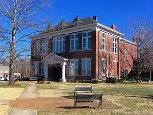 Cheatham County Courthouse in Ashland City | |
 Seal | |
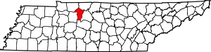 Location within the U.S. state of Tennessee | |
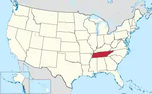 Tennessee's location within the U.S. | |
| Coordinates: 36°16′N 87°05′W | |
| Country | |
| State | |
| Founded | February 28, 1856 |
| Named for | Edward Saunders Cheatham[1] or Benjamin F. Cheatham[2] |
| Seat | Ashland City |
| Largest town | Ashland City |
| Area | |
| • Total | 307 sq mi (800 km2) |
| • Land | 302 sq mi (780 km2) |
| • Water | 4.6 sq mi (12 km2) 1.5%% |
| Population | |
| • Estimate (2019) | 40,667[3] |
| • Density | 133/sq mi (51/km2) |
| Time zone | UTC−6 (Central) |
| • Summer (DST) | UTC−5 (CDT) |
| Congressional districts | 5th, 6th |
| Website | www |
Cheatham County is part of the Nashville-Davidson–Murfreesboro–Franklin, TN Metropolitan Statistical Area. It is located in Middle Tennessee.
History
Cheatham County was created by an Act of the Tennessee General Assembly in 1856, from lands formerly of Davidson, Dickson, Montgomery, and Robertson counties. Cheatham County was named for Edward Saunders Cheatham, a state legislator.[1]
Geography
According to the U.S. Census Bureau, the county has a total area of 307 square miles (800 km2), of which 302 square miles (780 km2) is land and 4.6 square miles (12 km2) (1.5%) is water.[6]
The county is bisected from northwest to southeast by the Cumberland River, with Ashland City located on its northern bank. The southern portion of the county is bisected from southeast to northwest by the Harpeth River, which meanders through generally hilly country, and along whose course are located the communities of Kingston Springs, largely to the north of Interstate 40 (I-40), and Pegram, along U.S. Route 70 (US 70). The western border of the central portion of the county is defined by the course of the Harpeth. The hills east of the Harpeth and south of the Cumberland are partly set aside by the state as the Cheatham State Wildlife Management Area. North of Ashland City the hills subside into more level highlands, where the community of Pleasant View is located just south of I-24, which generally delineates the northern border of the county.
Adjacent counties
- Robertson County (northeast)
- Davidson County (east)
- Williamson County (south)
- Dickson County (west)
- Montgomery County (northwest)
State protected areas
- Cheatham Wildlife Management Area
- Cheatham Lake Wildlife Management Area (part)
- Harpeth River State Park
Demographics
| Historical population | |||
|---|---|---|---|
| Census | Pop. | %± | |
| 1860 | 7,258 | — | |
| 1870 | 6,678 | −8.0% | |
| 1880 | 7,956 | 19.1% | |
| 1890 | 8,845 | 11.2% | |
| 1900 | 10,112 | 14.3% | |
| 1910 | 10,540 | 4.2% | |
| 1920 | 10,039 | −4.8% | |
| 1930 | 9,025 | −10.1% | |
| 1940 | 9,928 | 10.0% | |
| 1950 | 9,167 | −7.7% | |
| 1960 | 9,428 | 2.8% | |
| 1970 | 13,199 | 40.0% | |
| 1980 | 21,616 | 63.8% | |
| 1990 | 27,140 | 25.6% | |
| 2000 | 35,912 | 32.3% | |
| 2010 | 39,105 | 8.9% | |
| 2019 (est.) | 40,667 | [7] | 4.0% |
| U.S. Decennial Census[8] 1790-1960[9] 1900-1990[10] 1990-2000[11] 2010-2014[4] | |||
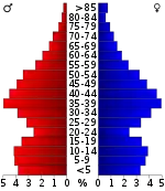
At the 2000 census there were 35,912 people, 12,878 households, and 10,160 families in the county. The population density was 119 people per square mile (46/km2). There were 13,508 housing units at an average density of 45 per square mile (17/km2). The racial makeup of the county was 96.86% White, 1.48% Black or African American, 0.38% Native American, 0.18% Asian, 0.05% Pacific Islander, 0.36% from other races, and 0.70% from two or more races. 1.22%.[13] were Hispanic or Latino of any race.
In 2005 The racial makeup of the county was 94.8% non-Hispanic whites, 2.1% African-Americans and 1.7% Latinos. In 2000 Of the 12,878 households 39.60% had children under the age of 18 living with them, 64.90% were married couples living together, 9.60% had a female householder with no husband present, and 21.10% were non-families. 16.90% of households were one person and 5.30% were one person aged 65 or older. The average household size was 2.76 and the average family size was 3.08.
The age distribution was 27.70% under the age of 18, 7.30% from 18 to 24, 33.50% from 25 to 44, 23.00% from 45 to 64, and 8.60% 65 or older. The median age was 35 years. For every 100 females, there were 100.30 males. For every 100 females age 18 and over, there were 97.40 males.
The median household income was $45,836 and the median family income was $49,143. Males had a median income of $34,476 versus $25,191 for females. The per capita income for the county was $18,882. About 5.30% of families and 7.40% of the population were below the poverty line, including 7.60% of those under age 18 and 9.40% of those age 65 or over.
Communities
City
Towns
- Ashland City (county seat)
- Kingston Springs
- Pegram
Unincorporated communities
- Bell Town
- Chapmansboro
- Craggie Hope
- Joelton (partial)
- Shacklett
Politics
Cheatham County is a Republican stronghold: the last Democrat to carry this county was Bill Clinton in 1996. The county is politically a typical “Solid South” rural county whose support for secession made it rock-ribbed Democratic until the middle 1960s when hostility towards civil rights for blacks drove it to George Wallace in 1968 and Richard Nixon in 1972, before turning to more centrist Democrats until the 1990s and rapidly and permanently away from the socially liberal 21st century Democratic Party.
| Year | Republican | Democratic | Third Parties |
|---|---|---|---|
| 2020 | 71.3% 14,328 | 27.2% 5,457 | 1.5% 306 |
| 2016 | 70.9% 11,297 | 24.4% 3,878 | 4.7% 749 |
| 2012 | 67.6% 10,268 | 30.7% 4,659 | 1.7% 255 |
| 2008 | 65.1% 10,702 | 33.5% 5,498 | 1.4% 228 |
| 2004 | 61.6% 9,676 | 37.7% 5,918 | 0.7% 103 |
| 2000 | 50.4% 6,356 | 48.1% 6,062 | 1.6% 198 |
| 1996 | 43.0% 4,283 | 49.0% 4,883 | 8.0% 798 |
| 1992 | 35.7% 3,496 | 49.2% 4,817 | 15.1% 1,475 |
| 1988 | 57.0% 4,132 | 42.3% 3,067 | 0.7% 51 |
| 1984 | 57.3% 4,109 | 41.9% 3,007 | 0.7% 53 |
| 1980 | 37.0% 2,296 | 60.8% 3,771 | 2.2% 134 |
| 1976 | 24.3% 1,376 | 74.6% 4,225 | 1.1% 63 |
| 1972 | 60.1% 2,235 | 35.5% 1,321 | 4.4% 163 |
| 1968 | 17.0% 669 | 19.7% 778 | 63.3% 2,497 |
| 1964 | 22.6% 803 | 77.4% 2,750 | |
| 1960 | 26.2% 683 | 72.2% 1,883 | 1.6% 41 |
| 1956 | 17.7% 498 | 81.7% 2,297 | 0.6% 16 |
| 1952 | 19.3% 536 | 80.0% 2,222 | 0.7% 18 |
| 1948 | 6.3% 193 | 88.6% 2,731 | 5.2% 159 |
| 1944 | 13.4% 216 | 86.5% 1,398 | 0.1% 2 |
| 1940 | 14.6% 331 | 85.3% 1,932 | 0.1% 3 |
| 1936 | 11.9% 183 | 87.6% 1,352 | 0.5% 8 |
| 1932 | 11.5% 180 | 87.7% 1,370 | 0.8% 12 |
| 1928 | 34.8% 488 | 65.1% 913 | 0.1% 2 |
| 1924 | 17.0% 181 | 81.4% 868 | 1.6% 17 |
| 1920 | 31.8% 569 | 68.1% 1,219 | 0.2% 3 |
| 1916 | 28.1% 439 | 71.5% 1,117 | 0.4% 6 |
| 1912 | 20.3% 317 | 70.3% 1,096 | 9.4% 146 |
Notable People
References
- James B. Hallums, "Cheatham County," Tennessee Encyclopedia of History and Culture. Retrieved: 23 June 2013.
- Gannett, Henry (1905). The Origin of Certain Place Names in the United States. Govt. Print. Off. p. 77.
- "U.S. Census website". United States Census Bureau. Retrieved 2018-05-02.
- "State & County QuickFacts". United States Census Bureau. Archived from the original on July 8, 2011. Retrieved November 29, 2013.
- "Find a County". National Association of Counties. Archived from the original on 2011-05-31. Retrieved 2011-06-07.
- "2010 Census Gazetteer Files". United States Census Bureau. August 22, 2012. Retrieved April 2, 2015.
- "Population and Housing Unit Estimates". Retrieved July 20, 2019.
- "U.S. Decennial Census". United States Census Bureau. Retrieved April 2, 2015.
- "Historical Census Browser". University of Virginia Library. Retrieved April 2, 2015.
- Forstall, Richard L., ed. (March 27, 1995). "Population of Counties by Decennial Census: 1900 to 1990". United States Census Bureau. Retrieved April 2, 2015.
- "Census 2000 PHC-T-4. Ranking Tables for Counties: 1990 and 2000" (PDF). United States Census Bureau. April 2, 2001. Retrieved April 2, 2015.
- Based on 2000 census data
- "U.S. Census website". United States Census Bureau. Retrieved 2011-05-14.
- Leip, David. "Dave Leip's Atlas of U.S. Presidential Elections". uselectionatlas.org. Retrieved 2018-03-10.
External links
| Wikimedia Commons has media related to Cheatham County, Tennessee. |
- Official site
- Cheatham County Chamber of Commerce
- Cheatham County, TNGenWeb - free genealogy resources for the county
- Cheatham County at Curlie
Places adjacent to Cheatham County, Tennessee | ||||||||||
|---|---|---|---|---|---|---|---|---|---|---|
| ||||||||||
Municipalities and communities of Cheatham County, Tennessee, United States | ||
|---|---|---|
| City | ||
| Towns | ||
| Unincorporated communities | ||
| ||
| Principal City | ||
|---|---|---|
| Other Major Cities | ||
| Counties | ||

| Authority control |
|---|