Upper Athabasca Region
The Upper Athabasca Region is a land-use framework region in northern Alberta, Canada. One of seven in the province, each is intended to develop and implement a regional plan, complementing the planning efforts of member municipalities in order to coordinate future growth. Corresponding roughly to major watersheds while following municipal boundaries, these regions are managed by Alberta Environment and Parks.[1]
Upper Athabasca Region | |
|---|---|
 Jasper National Park | |
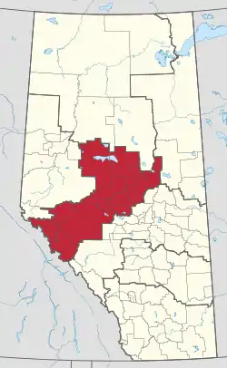 Location in Alberta | |
| Largest population centres | Whitecourt Hinton Edson Slave Lake |
| Government | |
| • Parent authority | Alberta Environment and Parks |
| Area | |
| • Total | 83,004 km2 (32,048 sq mi) |
| Population (2016)[3] | |
| • Total | 122,806 |
| • Density | 1.5/km2 (3.8/sq mi) |
Communities
The following municipalities are contained in the Upper Athabasca Region.
References
- "Land-use Framework". Alberta Environment and Parks. Retrieved 2019-07-07.
- "Land-use Planning Regions". Alberta Biosphere Monitoring Initiative. Retrieved 2019-07-07.
- "Population and dwelling counts, for Canada, provinces and territories, and census subdivisions (municipalities), 2016 and 2011 censuses – 100% data (Alberta)". Statistics Canada. February 8, 2017. Retrieved 2019-07-07.
This article is issued from Wikipedia. The text is licensed under Creative Commons - Attribution - Sharealike. Additional terms may apply for the media files.