Walpole (CDP), New Hampshire
Walpole is a census-designated place (CDP) and the main village in the town of Walpole in Cheshire County, New Hampshire, United States. The population of the CDP was 605 at the 2010 census,[1] out of 3,734 people in the entire town of Walpole.
Walpole, New Hampshire | |
|---|---|
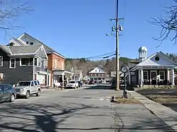 Westminster Street in the center of Walpole | |
 Walpole  Walpole | |
| Coordinates: 43°4′46″N 72°25′32″W | |
| Country | United States |
| State | New Hampshire |
| County | Cheshire |
| Town | Walpole |
| Area | |
| • Total | 1.23 sq mi (3.18 km2) |
| • Land | 1.22 sq mi (3.15 km2) |
| • Water | 0.01 sq mi (0.03 km2) |
| Elevation | 397 ft (121 m) |
| Population (2010) | |
| • Total | 605 |
| • Density | 497/sq mi (191.9/km2) |
| Time zone | UTC-5 (Eastern (EST)) |
| • Summer (DST) | UTC-4 (EDT) |
| ZIP code | 03608 |
| Area code(s) | 603 |
| FIPS code | 33-78340 |
| GNIS feature ID | 2629744 |
Geography
The CDP is in the west-center part of the town of Walpole, on the east side of the valley of the Connecticut River. The western edge of the CDP follows New Hampshire Route 12, from the outlet of Mill Pond in the north to an unnamed brook south of South Street in the south. The CDP extends southeast to Prospect Hill Road as far as Watkins Hill Road and Maple Grove Road, while the eastern border of the CDP follows North Road and an unnamed brook back to Mill Pond.[2]
Route 12 leads north 4.5 miles (7.2 km) to North Walpole, across the Connecticut River from Bellows Falls, Vermont, and 11 miles (18 km) to Charlestown, while to the south it leads 17 miles (27 km) to Keene. New Hampshire Route 123 leaves Route 12 just west of the town center and leads west across the Connecticut to Westminster, Vermont.
According to the U.S. Census Bureau, the Walpole CDP has a total area of 1.2 square miles (3.2 km2), of which 0.01 square miles (0.03 km2), or 0.86%, are water.[1]
Demographics
As of the census of 2010, there were 605 people, 315 households, and 163 families residing in the CDP. There were 346 housing units, of which 31, or 9.0%, were vacant. The racial makeup of the town was 97.2% White, 0.3% African American, 0.0% Native American, 0.8% Asian, 0.0% Pacific Islander, 0.0% some other race, and 1.7% from two or more races. 1.3% of the population were Hispanic or Latino of any race.[3]
Of the 315 households in the CDP, 15.6% had children under the age of 18 living with them, 42.9% were headed by married couples living together, 7.0% had a female householder with no husband present, and 48.3% were non-families. 39.4% of all households were made up of individuals, and 18.4% were someone living alone who was 65 years of age or older. The average household size was 1.92, and the average family size was 2.54.[3]
13.1% of people in the CDP were under the age of 18, 6.3% were from 18 to 24, 18.1% were from 25 to 44, 35.6% were from 45 to 64, and 26.9% were 65 years of age or older. The median age was 53.0 years. For every 100 females, there were 79.5 males. For every 100 females age 18 and over, there were 80.1 males.[3]
For the period 2011-15, the estimated median annual income for a household was $46,061, and the median income for a family was $85,278. The per capita income for the CDP was $35,659. [4]
References
- "Geographic Identifiers: 2010 Demographic Profile Data (G001): Walpole CDP, New Hampshire". U.S. Census Bureau, American Factfinder. Archived from the original on February 13, 2020. Retrieved August 29, 2017.
- "TIGERweb: Walpole CDP, New Hampshire". Geography Division, U.S. Census Bureau. Retrieved January 25, 2021.
- "Profile of General Population and Housing Characteristics: 2010 Census Summary File 1 (DP-1): Walpole CDP, New Hampshire". U.S. Census Bureau, American Factfinder. Archived from the original on February 13, 2020. Retrieved August 29, 2017.
- "Selected Economic Characteristics: 2011-2015 American Community Survey 5-Year Estimates (DP03): Walpole CDP, New Hampshire". U.S. Census Bureau, American Factfinder. Archived from the original on February 13, 2020. Retrieved August 29, 2017.
Municipalities and communities of Cheshire County, New Hampshire, United States | ||
|---|---|---|
| City |  Map of New Hampshire highlighting Cheshire County | |
| Towns | ||
| CDPs | ||
| Other villages | ||
| ||