Wimbolds Trafford
Wimbolds Trafford is a hamlet and former civil parish, now in the parish of Mickle Trafford and District, in the unitary authority of Cheshire West and Chester and the ceremonial county of Cheshire, England. The hamlet lies on the B5132 road, approximately 5 miles (8 km) to the north east of Chester and north of the village of Mickle Trafford. (grid reference SJ44)
| Wimbolds Trafford | |
|---|---|
 Ince Lane | |
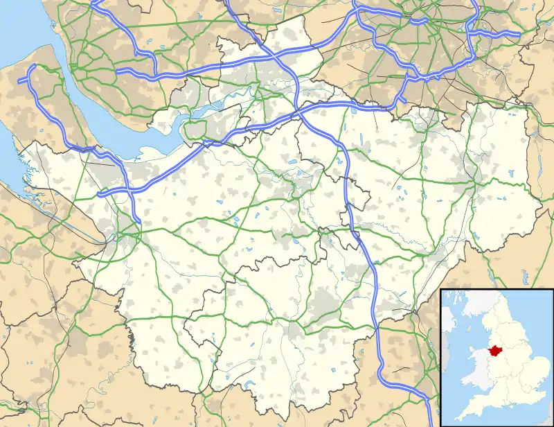 Wimbolds Trafford Location within Cheshire | |
| Population | 212 (2011 census) |
| OS grid reference | SJ446724 |
| Civil parish |
|
| Unitary authority | |
| Ceremonial county | |
| Region | |
| Country | England |
| Sovereign state | United Kingdom |
| Post town | CHESTER |
| Postcode district | CH2 |
| Police | Cheshire |
| Fire | Cheshire |
| Ambulance | North West |
| UK Parliament | |
At the 2011 census the civil parish had a population of 212.[1]
History
The present name Wimbolds Trafford comes from Winebald's Trafford, with the latter meaning "valley ford". Winebald (a personal noun) is combined with the Old English words trog (a trough or hollow) and ford (a ford or crossing).[2]
Wimbolds Trafford was recorded in the Domesday Book with a population of three households of "two smallholders and one riders". Consisting of one ploughland under the ownership of Earl Hugh of Chester, it had a taxable value of "1 geld units".[3]
Wimbold Trafford in the early 1870s was described as:
- ...a township in Thornton-le-Moors parish, Cheshire; 4¼ miles NE of Chester. Acres, 574. Real property, £1,081. Pop., 113. Houses, 18.[4]
Formerly a township in Thornton ancient parish of Eddisbury Hundred, it became a civil parish in 1866. In 1888 part of Bridge Trafford was added to the parish. Further boundary changes occurred on 1 April 1963 with the neighbouring civil parishes of Picton and Wervin.[5]
Governance
Wimbolds Trafford is within the Ellesmere Port and Neston parliamentary constituency.
At local government level it is part of the Gowy Rural Ward of the Cheshire West and Chester unitary authority as of 2021. The civil parish was abolished in 2015 to form Mickle Trafford and District, part of it also went to Dunham-on-the-Hill and Hapsford.[5] The local parish council meets monthly in nearby Mickle Trafford.[6]
Demography
Population
The current population as recorded by 2011 census is 212 (109 males and 103 females).[1]
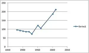
| Historical census figures | ||||
|---|---|---|---|---|
| Year | Population | |||
| 1801 | 111 | |||
| 1851 | 106 | |||
| 1881 | 97 | |||
| 1901 | 90 | |||
| 1911 | 86 | |||
| 1921 | 86 | |||
| 1931 | 73 | |||
| 1951 | 122 | |||
| 2001 | 188 (civil parish)[7]
97 (hamlet)[5] | |||
Employment

This graph shows clearly occupation data for both males and females in 1881. Work in agriculture is the most common occupation for men, while for women the highest occupation is in the domestic service.

According to the most modern census data (2011) 117 of the residents between 16 and 74 are in employment. The most popular avenue of work being Wholesale and Retail Trade; Repair of Motor Vehicles and Motor Cycles. 15.4% of the working residents work in this sector, the next highest was education at 11.1%.[1]
Landmarks
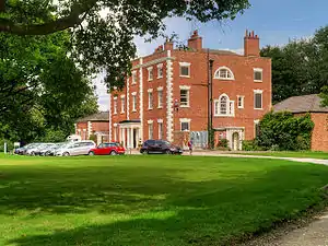
Trafford Hall was built in 1756 and is designated a Grade II* listed building.[8] As of 2021 the venue is used as a National Communities Resource Centre, which is a registered charity offering training and support to those living and working in low-income areas throughout the United Kingdom. Trafford Hall can also be hired out for events, conferences and as a wedding venue.

References
- UK Census (2011). "Local Area Report – Wimbolds Trafford CP (E05000963)". Nomis. Office for National Statistics. Retrieved 25 September 2020.
- Watts, Ekwall, Mills and Dodgston. "Key to English Place-Names". University of Nottingham. Retrieved 10 April 2013.CS1 maint: multiple names: authors list (link)
- Powel-Smith, Anna. "[WIMBOLDS] TRAFFORD". University of Hull. Retrieved 10 April 2013.
- Wilson, John (1870–72). Imperial Gazetteer of England and Wales. Edinburgh: A. Fullarton and Co. Retrieved 4 February 2013.
- "Wimbolds Trafford". GENUKI UK & Ireland Genealogy. Retrieved 24 March 2018.
- "Mickle Trafford & District". MickleTrafford.org.uk. Retrieved 25 September 2020.
- UK Census (2001). "Local Area Report – Wimbolds Trafford/Bridge Trafford/Picton CP (13UB116)". Nomis. Office for National Statistics. Retrieved 26 September 2020.
- Historic England. "Trafford Hall with attached service wing and carriage house (1145900)". National Heritage List for England. Retrieved 25 September 2020.
External links
![]() Media related to Wimbolds Trafford at Wikimedia Commons
Media related to Wimbolds Trafford at Wikimedia Commons
Cheshire Portal | |
| Unitary authorities | |
| Major settlements |
|
| Rivers | |
| Topics | |