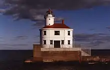
Wisconsin Point Light
The Wisconsin Point Light is a lighthouse located near Superior, on Wisconsin Point, in Douglas County, Wisconsin, United States.
 Wisconsin Point Lighthouse | |
 | |
| |
| Location | Superior Wisconsin |
|---|---|
| Coordinates | 46°42′36.5″N 92°00′23″W[1] |
| Year first constructed | 1913 |
| Year first lit | 1913 |
| Automated | 1970 |
| Foundation | Concrete pier |
| Construction | Concrete |
| Tower shape | Cylindrical, atop square (rounded corners) keeper's house |
| Markings / pattern | White with red lantern, red roof on house |
| Tower height | 56 feet (17 m) |
| Focal height | 70 feet (21 m)[2] |
| Original lens | Fourth order Fresnel lens |
| Current lens | DCB 24 Carlisle & Finch Aerobeacon[3] |
| Range | 21 nautical miles (39 km; 24 mi)[1] |
| Characteristic | Green flashing, 5 s[1] |
| Fog signal | HORN: 1 blast ev 30s (3s bl); operates from May 1 to October 20 |
| ARLHS number | USA-829 |
| USCG number | 7-15595 |
| Heritage | place listed on the National Register of Historic Places |
Superior Entry South Breakwater Light | |
| Area | less than one acre |
| Built by | U.S. Bureau of Lighthouses |
| MPS | Light Stations of the United States MPS |
| NRHP reference No. | 07000102[4] |
| Added to NRHP | March 1, 2007 |
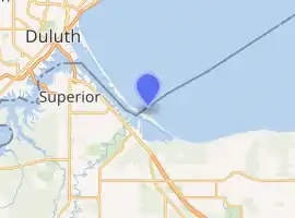
The light and attached fog horn building sits within a 10-mile (16 km) long sand bar – stretching between the ports of Duluth and Superior. This sand bar makes the Duluth–Superior Harbor one of the safest harbors in the world. It is "reputedly the longest freshwater sand bar in the world" and is split by this opening near its center, where the lighthouse is located. The Minnesota side of the opening is known as "Minnesota Point" (Park Point) and the Wisconsin side is known as "Wisconsin Point."[5] It was added to the National Register of Historic Places in 2007.[4] It stands erect at 70 ft. tall.
History
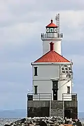
The original Fresnel lens was manufactured by Sautter, Lemonnier, and Company of Paris in 1890.[6] It was replaced with a DCB-224 aero beacon[7] manufactured by the Carlisle & Finch Company.[8]
It is an active navigational aid and is known as the South Breakwater Light by the United States Coast Guard in the Volume VII light list and the United States Geological Survey Geographic Names Information System.
It is located on the southern Superior Harbor entry breakwall. The Saint Louis River, which rises in Minnesota, becomes the Saint Louis Bay, then flows into Superior Bay and exits into Lake Superior via the ship canals, at each end of (Park Point) Minnesota Point.
In July 2019, the lighthouse superstructure was put up for sale in an online auction by the U.S. GSA. The breakwater upon which it sits and the navigational aid housed within would remain U.S. Government property after the sale.[9]
References
- Light List, Volume VII, Great Lakes (PDF). Light List. United States Coast Guard. 2014.
- Pepper, Terry. "Seeing the Light: Lighthouses on the western Great Lakes".
- National Park Service, Maritime History Project, Inventory of Historic Light Stations - Wisconsin - Wisconsin Point Light.
- "National Register Information System". National Register of Historic Places. National Park Service. November 2, 2013.
- Terry Pepper, Seeing the Light, Superior Entry Lighthouse.
- Wobser, David, Wisconsin Point (Superior South Breakwater) Light, boatnerd.com Archived 2008-07-25 at the Wayback Machine
- Aero beacon, Terry Pepper, Seeing the Light.
- Carlisle & Finch Company.
- "Superior Entry Light". GSA Auctions. U.S. General Services Administration. Archived from the original on 14 August 2019. Retrieved 14 August 2019.
Further reading
- Havighurst, Walter (1943) The Long Ships Passing: The Story of the Great Lakes, Macmillan Publishers.
- Oleszewski, Wes, Great Lakes Lighthouses, American and Canadian: A Comprehensive Directory/Guide to Great Lakes Lighthouses, (Gwinn, Michigan: Avery Color Studios, Inc., 1998) ISBN 0-932212-98-0.
- Pepper, Terry. "Seeing the Light: Lighthouses on the western Great Lakes".
- Wright, Larry and Wright, Patricia, Great Lakes Lighthouses Encyclopedia Hardback (Erin: Boston Mills Press, 2006) ISBN 1-55046-399-3.
External links
![]() Media related to Wisconsin Point Light at Wikimedia Commons
Media related to Wisconsin Point Light at Wikimedia Commons
- Aerial photos of Wisconsin Point, South Breakwater Light, Marina.com.
- Rowlett, Russ. "Lighthouses of the United States: Northern Wisconsin". The Lighthouse Directory. University of North Carolina at Chapel Hill.
- Lighthouse friends, Wisconsin Point Light article
- Satellite view, Superior Entry South Breakwater (Wisconsin Point) Light, by Google.com.
- "Historic Light Station Information and Photography: Wisconsin". United States Coast Guard Historian's Office. Archived from the original on 2017-05-01.
- Light List, Volume VII, Great Lakes (PDF). Light List. United States Coast Guard.
| Lake Superior | 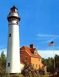 | |
|---|---|---|
| Lake Michigan |
| |
| Lake Winnebago | ||
| Historical (lost) lights |
| |
| Topics | |
|---|---|
| Lists by state |
|
| Lists by insular areas | |
| Lists by associated state | |
| Other areas | |
| Related | |
| |