1509 Constantinople earthquake
The 1509 Constantinople earthquake historically Kıyamet-i Sugra or (Little Judgment Day) occurred in the Sea of Marmara on 10 September 1509 at about 10 p.m. The earthquake had an estimated magnitude of 7.2 ± 0.3 on the surface wave magnitude scale.[2] A tsunami and forty-five days of aftershocks followed the earthquake. The death toll of this earthquake is poorly known, with estimates in the range of 1,000 to 13,000.
 | |
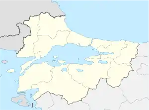 Location of epicenter in the Marmara region | |
| Local date | 10 September 1509 |
|---|---|
| Local time | 22:00 |
| Magnitude | 7.2 Ms ± 0.3 |
| Epicenter | 40.9°N 28.7°E[1] |
| Fault | North Anatolian Fault |
| Areas affected | Ottoman Empire |
| Tsunami | yes |
| Casualties | 1,000 to 13,000 |
Background
The Sea of Marmara is a pull-apart basin formed at a releasing bend in the North Anatolian Fault, a right-lateral strike-slip fault. This local zone of extension occurs where this transform boundary between the Anatolian Plate and the Eurasian Plate steps northwards to the west of Izmit from the Izmit Fault to the Ganos Fault. The pattern of faults within the Sea of Marmara basin is complex but near Istanbul there is a single main fault segment with a sharp bend. To the west, the fault trends west–east and is pure strike-slip in type. To the east, the fault is NW-SE trending and shows evidence of both normal and strike-slip motion.[3] Movement on this fault, which bounds the Çınarcık Basin, was the most likely cause of the 1509 event.[2]
Damage
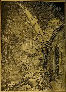
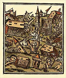
The area of significant damage (greater than VII (Very strong)) extended from Çorlu in the west to Izmit in the east. Galata and Büyükçekmece also suffered severe damage. In Constantinople 109 mosques were utterly destroyed, while most of those left standing suffered damage to their minarets. While 1070 homes collapsed, 49 towers along the Walls of Constantinople also collapsed or were damaged. The newly built Bayezid II Mosque was badly damaged; the main dome was destroyed and a minaret collapsed. The Fatih Mosque suffered damage to its four great columns and the dome was split. The quake also damaged the Rumeli Fortress, Anadolu Fortress, the Yoros Castle in Anadolu Kavağı, and the Maiden's Tower.[4] The Grand Mosque of Hagia Sophia survived almost unscathed, although a minaret collapsed. Inside the mosque, the plaster that had been used to cover up the Byzantine mosaics inside the dome fell off, revealing the Christian images.[2]
The number of dead and injured is hard to estimate, with different sources giving accounts varying from 1,000 to 13,000.[2] It is believed that some members of the Ottoman dynasty died in this earthquake. Aftershocks continued for 45 days after the earthquake, and people were unable to return to their homes for two months.[4] Ottoman Turks felt that doomsday had arrived. Indeed, the quake was so destructive for Constantinople that historians referred to it as “Kıyamet-i Sugra” or “Little Doomsday.” [4]
Aftermath
The earthquake was allegedly predicted by an unnamed Greek monk from Saint Catherine's Monastery in Sinai while present in the Sultan's court.[2] European interpretations at the time viewed the earthquake as a sort of punishment, a punishment from God set upon the Turks for taking up arms against European Christians.[2] Similarly, Bayezid II saw it as a punishment from God, however he attributed the punishment to the wrongdoings of his ministers.[2] The sultan’s residence Topkapı Palace was not damaged but Bayezid II’s bedroom collapsed at the tremor, with the sultan only saved by the fact he had left his chambers only hours earlier. After staying for ten days in a tent set up in the palace garden, Bayezid II went to stay in former capital of Edirne. [4]
The Ottoman Imperial Council (Divan-ı Hümayun) convened after the quake and made decisions to deal with the effects of the disaster. Constantinople had to be reconstructed and an additional tax of 22 akçe would be taken from each household for the task, it was decided. Afterward, an empire-wide initiative was launched to reconstruct the city. Tens of thousands of workers, stonemasons and carpenters were brought to Istanbul from both Anatolia and Rumelia. Beginning on March 29, 1510, construction works in the city were undergone hastily and completed on June 1, 1510. [4]
Characteristics
Earthquake
From the area and intensity of shaking, a 70 km (43 mi) fault rupture has been estimated.[2] Major shocks occurred at half hour intervals and was violent and protracted in nature, forcing residents to seek refuge in open parks and squares.[2] Aftershocks were said to have continued for 18 days without causing any further damage, however it did delay reconstruction in some areas.[2]
References
- Ambraseys, N.N.; Jackson J.A. (2000). "Seismicity of the Sea of Marmara (Turkey) since 1500". Geophysical Journal International. 141 (3): F1–F6. Bibcode:2000GeoJI.141F...1A. doi:10.1046/j.1365-246x.2000.00137.x.
- Ambraseys, N. N. (December 2001). "The Earthquake of 1509 in the Sea of Marmara, Turkey, Revisited". Bulletin of the Seismological Society of America. 91 (6): 1397–1416. Bibcode:2001BuSSA..91.1397A. CiteSeerX 10.1.1.861.7616. doi:10.1785/0120000305.
- Armijo, R.; Meyer B.; Navarro S.; King G. & Narka A. (2002). "Asymmetric slip partitioning in the Sea of Marmara pull-apart: a clue to propagation processes of the North Anatolian Fault?" (PDF). Terra Nova. 14 (2): 80–86. Bibcode:2002TeNov..14...80A. CiteSeerX 10.1.1.546.4111. doi:10.1046/j.1365-3121.2002.00397.x. Retrieved 2010-02-06.
- Afyoncu, Erhan (28 July 2020). "A glimpse of doom: Istanbul's earthquakes in history". Historian, Chancellor of National Defence University, Ankara. Daily Sabah. Retrieved 10 September 2020.
- Lozefski, G.; McHugh C.; Cormier M-H.; Seeber L.; Çagatay N.; Okay N. (2004). "Provenance of turbidite sands in the Marmara Sea, Turkey: a tool for submarine paleoseismology". Archived from the original on 8 June 2011. Retrieved 6 February 2010.