Acıgöl
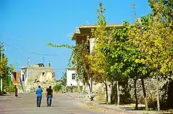
Acıgöl, (pronounced [ˈadʒɯɡœɫ]) formerly Dobada, is a town and district of Nevşehir Province in the Central Anatolia region of Turkey. According to 2010 census, population of the district is 15,040 of which 5,825 live in the town of Acıgöl, and the remainder in surrounding villages.[3] The district covers an area of 497 km2 (192 sq mi),[4] and the town lies at an average elevation of 1,256 m (4,121 ft). Acıgöl has 5 towns and 8 villages.[5]
Acıgöl | |
|---|---|
District | |
 | |
 Location of Acıgöl within Turkey. | |
 Acıgöl Location of Acıgöl within Turkey. | |
| Coordinates: 38°33′N 34°31′E | |
| Country | |
| Region | Central Anatolia |
| Province | Nevşehir |
| Government | |
| • Governor | Ferit Görükmez |
| • Mayor | İsmail Çavuşoğlu (AKP) |
| Area | |
| • District | 497.29 km2 (192.00 sq mi) |
| Elevation | 1,256 m (4,121 ft) |
| Population (2012)[2] | |
| • Urban | 5,817 |
| • District | 19,943 |
| • District density | 40/km2 (100/sq mi) |
| Time zone | UTC+2 (EET) |
| • Summer (DST) | UTC+3 (EEST) |
| Postal code | 50xxx |
| Area code(s) | 0384 |
| Vehicle registration | 50 |
| Climate | Csb |
| Website | www |
Notes
- "Area of regions (including lakes), km²". Regional Statistics Database. Turkish Statistical Institute. 2002. Retrieved 2013-03-05.
- "Population of province/district centers and towns/villages by districts - 2012". Address Based Population Registration System (ABPRS) Database. Turkish Statistical Institute. Retrieved 2013-02-27.
- Statistical Institute
- Statoids. "Statistical information on districts of Turkey". Archived from the original on 2010-05-26. Retrieved 2008-04-12.
- http://www.acigol.bel.tr/acigol/acigoltarihcesi
References
- Falling Rain Genomics, Inc. "Geographical information on Acıgöl, Turkey". Retrieved 2008-04-07.
- Municipality of Acıgöl, Turkey. "General information on Acıgöl, Nevşehir" (in Turkish). Archived from the original on March 15, 2008. Retrieved 2008-04-07.
External links
| Wikimedia Commons has media related to Acıgöl. |
- District governor's official website (in Turkish)
- District municipality's official website (in Turkish)
- Administrative map of Acıgöl district
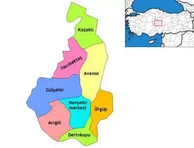
Acıgöl in Nevşehir Province of Turkey | |||||||||||||||||||||||||||
|---|---|---|---|---|---|---|---|---|---|---|---|---|---|---|---|---|---|---|---|---|---|---|---|---|---|---|---|
| Districts | Districts of Nevşehir | ||||||||||||||||||||||||||
| |||||||||||||||||||||||||||
Metropolitan municipalities are bolded. | |||||||||||||||||||||||||||
This article is issued from Wikipedia. The text is licensed under Creative Commons - Attribution - Sharealike. Additional terms may apply for the media files.
