Gülşehir
Gülşehir, formerly Aravissos and Arapsun, ancient Zoropassos (Ancient Greek: Ζωρόπασος), is a town and district of Nevşehir Province in the Central Anatolia region of Turkey, in the vicinity of the Fairy Chimney valley of Göreme. According to 2010 census, population of the district is 24,503 of which 8,866 live in the town of Gülşehir, and the remainder in surrounding villages.[3][4] The district covers an area of 956 km2 (369 sq mi),[5] and the average elevation is 885 m (2,904 ft).
Gülşehir | |
|---|---|
District | |
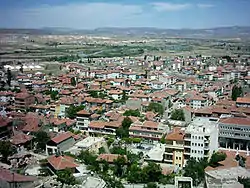 A panorama of Gülşehir | |
 Location of Gülşehir within Turkey. | |
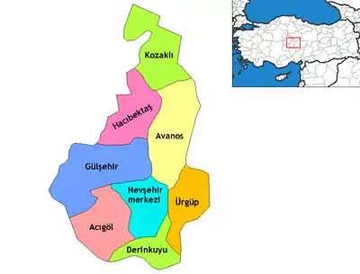
 Gülşehir Location of Gülşehir within Turkey. | |
| Coordinates: 38°45′N 34°37′E | |
| Country | |
| Region | Central Anatolia |
| Province | Nevşehir |
| Government | |
| • Governor | Mesut Yakuta |
| • Mayor | Vahdi ARISOY (MHP) |
| Area | |
| • District | 955.80 km2 (369.04 sq mi) |
| Elevation | 885 m (2,904 ft) |
| Population (2012)[2] | |
| • Urban | 8,932 |
| • District | 23,437 |
| • District density | 25/km2 (64/sq mi) |
| Time zone | UTC+2 (EET) |
| • Summer (DST) | UTC+3 (EEST) |
| Postal code | 50xxx |
| Area code(s) | 0384 |
| Licence plate | 50 |
| Climate | Csb |
| Website | www.gulsehir.gov.tr |
History
The old name of Gülşehir, situated on the southern bank of the Kızıl River, 20 km from Nevşehir, is Arapsun and in ancient times it was called “Zoropassos” by the Hittites. In the vicinity of Gülşehir there are still rocks and steles with inscriptions from the Hittites.
The Ottoman Grand Vizier Karavezir Mehmet Seyyid Pasha did the same thing in Gülşehir as Damat İbrahim Pasha did in the nearby Nevşehir and a külliye was built in the town which had only 30 houses. The complex consisted of a mosque, a madrasah and a fountain.
According to the Ottoman General Census of 1881/82-1893, the kaza of Gülşehir had a total population of 14.984, consisting of 11.029 Muslims, 3.935 Greeks and 20 Armenians.[6]
The pottery, located completely inside an artificial cave deep in the rock, is a local tourist attraction.
Villages and towns
Villages and towns in the district:
Notes
- "Area of regions (including lakes), km²". Regional Statistics Database. Turkish Statistical Institute. 2002. Retrieved 2013-03-05.
- "Population of province/district centers and towns/villages by districts - 2012". Address Based Population Registration System (ABPRS) Database. Turkish Statistical Institute. Retrieved 2013-02-27.
- Statistical Institute
- GeoHive. "Statistical information on Turkey's administrative units". Retrieved 2008-04-09.
- Statoids. "Statistical information on districts of Turkey". Retrieved 2008-04-12.
- Kemal Karpat (1985), Ottoman Population, 1830-1914, Demographic and Social Characteristics, The University of Wisconsin Press, p. 142-143
References
- Falling Rain Genomics, Inc. "Geographical information on Gülşehir, Turkey". Retrieved 2008-04-09.
- Governorship of Gülşehir, Turkey. "General information on Gülşehir, Nevşehir" (in Turkish). Archived from the original on May 15, 2008. Retrieved 2008-04-09.
External links
| Wikimedia Commons has media related to Gülşehir. |
- A detailed website about Gülşehir
- District governor's official website (in Turkish)
- Map of Gülşehir district
- Administrative map of Gülşehir district
Gülşehir in Nevşehir Province of Turkey | |||||||||||||||||||||||||||
|---|---|---|---|---|---|---|---|---|---|---|---|---|---|---|---|---|---|---|---|---|---|---|---|---|---|---|---|
| Districts | Districts of Nevşehir | ||||||||||||||||||||||||||
| |||||||||||||||||||||||||||
Metropolitan municipalities are bolded. | |||||||||||||||||||||||||||
| Authority control |
|
|---|