Agua Fria River
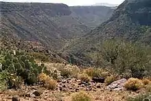
The Agua Fria River (Spanish for "cold water") is a 120-mile (190 km) long intermittent stream which flows generally south from 20 miles (32 km) east-northeast of Prescott in the U.S. state of Arizona. Prescott draws much of its municipal water supply from the upper Agua Fria watershed.[1] The Agua Fria runs through the Agua Fria National Monument. The river then flows through a small canyon called "Black Canyon" into Lake Pleasant, a popular recreation area near Peoria, Arizona. (There is a large "Black Canyon" on the Colorado River along the Arizona–Nevada border.)
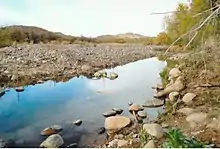
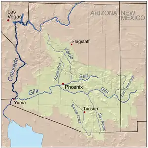
During rainy weather and at times when water is flowing in the intermittent Agua Fria River, it discharges into the Gila River, which also only flows during wet periods of the year.
The Central Arizona Water Conservation District of the Central Arizona Project operates the Agua Fria Recharge Project, which is about 4 miles (6.4 km) south of the New Waddell Dam. It serves to recharge underground aquifers in this area, and ends at Lake Pleasant, Phoenix.[2]
See also
References
- Upper Agua Fria Basin Archived September 27, 2006, at the Wayback Machine
- Agua Fria Recharge Project Archived January 17, 2008, at the Wayback Machine
External links
- Maricopa Audubon Society Page on the Agua Fria Wildlife Preserve
- Agua Fria River Master Plan, by Maricopa County
- Agua Fria - New River Natural Resource Conservation District
- Photos taken along the Agua Fria River
- Bureau of Land Management Page on the Agua Fria National Monument
| Authority control |
|
|---|
