Santa Maria River (Arizona)
The Santa Maria River is an intermittent stream located in western Arizona. It is a primary tributary of the Bill Williams River and one of the main sources of inflow for Alamo Lake. The river forms a portion of the boundary between Mohave and La Paz counties.
| Santa Maria River | |
|---|---|
 Seasonal flows in the Arrastra wilderness | |
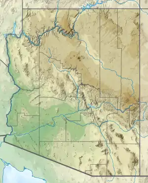 Location of the mouth of Santa Maria River in Arizona | |
| Location | |
| Country | United States |
| State | Arizona |
| Physical characteristics | |
| Source | |
| • elevation | 2,640 feet (800 m) |
| Mouth | |
• location | Alamo Lake |
• elevation | 1,240 feet (380 m) |
| Length | 50 miles (80 km) |
| Discharge | |
| • average | 11.59 cu ft/s (0.328 m3/s)[1] |
Course
The Santa Maria River is formed by the confluence of the Sycamore and Kirkland Creeks, about 10 miles (16 km) east of the community of Bagdad. From the confluence, the river flows in a generally southwesterly direction through the rugged Arrastra Mountain Wilderness area, (Poachie Range–Black Mountains). The river accepts a number of smaller, intermittent streams throughout its length.
The river joins the Big Sandy River to form the Bill Williams River just upstream of Alamo Lake. During periods of heavy rainfall, the lake may extend beyond the confluence point, during which period the Santa Maria empties directly into the lake rather than joining the Big Sandy River.
The total length of the river is approximately 50 miles (80 km), 17 miles (27 km) of which are considered perennial stream.[1] The remainder is ephemeral and runs only during periods of heavy rain.
See also
References
- "ANNUAL FLOWS FOR USGS STREAMGAGING STATIONS IN THE BILL WILLIAMS WATERSHED" (PDF). Arizona Department of Water Resources. Retrieved 2008-05-27.