Ajodhya, Bankura
Ajodhya is a village in the Bishnupur CD block in the Bishnupur subdivision of the Bankura district in the state of West Bengal, India.
Ajodhya | |
|---|---|
Village | |
 Ajodhya Location in West Bengal, India  Ajodhya Ajodhya (India) | |
| Coordinates: 23.154388°N 87.279252°E | |
| Country | |
| State | West Bengal |
| District | Bankura |
| Population (2011) | |
| • Total | 2,862 |
| Languages | |
| • Official | Bengali, English |
| Time zone | UTC+5:30 (IST) |
| PIN | 722163 |
| Telephone/STD code | 03244 |
| Lok Sabha constituency | Bishnupur |
| Vidhan Sabha constituency | Bishnupur |
| Website | bankura |
Geography
| Places in Bishnupur subdivision in Bankura district M: Municipal town, CT: census town, R: rural/ urban centre, T: ancient/ temple centre Owing to space constraints in the small map, the actual locations in a larger map may vary slightly |
Location
Ajodhya is located at 23.154388°N 87.279252°E.
Area overview
The map alongside shows the Bishnupur subdivision of Bankura district. Physiographically, this area has fertile low lying alluvial plains.[1] It is a predominantly rural area with 90.06% of the population living in rural areas and only 8.94% living in the urban areas.[2] It was a part of the core area of Mallabhum.[3]
Note: The map alongside presents some of the notable locations in the subdivision. All places marked in the map are linked in the larger full screen map.
Demographics
According to the 2011 Census of India, Ajodhya had a total population of 2,862, of which 1,445 (50%) were males and 1,417 (50%) were females. There were 280 persons in the age range of 0–6 years. The total number of literate persons in Ajodhya was 1,880 (72.81% of the population over 6 years).[4]
Education
Ajodhya High School is a Bengali-medium coeducational institution established in 1954. It has facilities for teaching from class V to class XII. The school has 10 computers and a library with 1,900 books.[5]
Swami Dhananjoy Das Kathiababa Mahavidyalaya was established at Bhara in 2009.[6]
Culture
David J. McCutchion mentions the Rasmancha at Ajodhya as a saptadasa-ratna with rekha turrets.[7]
The twelve Shiva temples at Ajodhya belong to the Ajodhya Debutter Estate of the Bandopadhay family. The Girigovardhan Mountain also belongs to the same family.
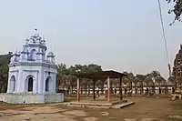 12 Shiva temples with Rasmancha
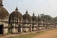 12 Shiva temples
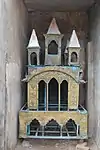 Brass ratha
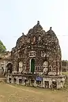 Girigovardhan Mountain
The pictures are a part of Wiki Explores Bankura programme, an initiative by West Bengal Wikimedians User Group
Healthcare
There is a primary health centre at Ajodhya, with 6 beds.[8]
References
- "District Census Handbook Bankura" (PDF). pages 13-17. Directorate of Census Operations West Bengal. Retrieved 23 April 2020.
- "District Statistical Handbook 2014 Bankura". Table 2.4b. Department of Statistics and Programme Implementation, Government of West Bengal. Retrieved 23 April 2020.
- O'Malley, L.S.S., ICS, Bankura, Bengal District Gazetteers, pp. 21–46, 1995 reprint, first published 1908, Government of West Bengal
- "CD block Wise Primary Census Abstract Data(PCA)". West Bengal – District-wise CD blocks. Registrar General and Census Commissioner, India. Retrieved 18 April 2020.
- "Ajodhya High School". Schools.org.in. Retrieved 4 May 2020.
- "Swami Dhananjoy Das Kathiababa Mahavidyalaya". SDDKM. Retrieved 8 May 2020.
- McCutchion, David J., Late Mediaeval Temples of Bengal, first published 1972, reprinted 2017, page 76. The Asiatic Society, Kolkata, ISBN 978-93-81574-65-2
- "Health & Family Welfare Department" (PDF). Health Statistics – Primary Health Centres. Government of West Bengal. Retrieved 10 April 2020.
External links
| Wikimedia Commons has media related to Ayodhya, Bankura. |
Cities, towns and locations in Bankura District | |||||||
|---|---|---|---|---|---|---|---|
| Cities, municipal and census towns |
| ||||||
| Locations other than cities and towns |
| ||||||
| Related topics |
| ||||||